Download
1 / 17
170 likes | 317 Vues
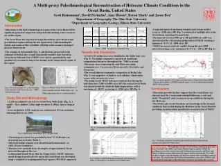
LAND USE/LAND COVER CHANGE EARLY WARNING SYSTEM AND CLIMATE CHANGE IN THE QUA IBOE RIVER BASIN, NIGERIA. EKPENYONG, Robert Etim Department Of Geography and Regional Planning University Of Uyo Uyo, AKS Nigeria. Introduction.

E N D
LAND USE/LAND COVER CHANGE EARLY WARNING SYSTEM AND CLIMATE CHANGE IN THE QUA IBOE RIVER BASIN, NIGERIA EKPENYONG, Robert Etim Department Of Geography and Regional Planning University Of Uyo Uyo, AKS Nigeria
Introduction • Studies have shown that information on land use/ land cover is required for rational and sustainable allocation of land resources for development [YANG and LO, 2003; EL-RAEY et.al., 2000; BRONSVELD et. al., 1994]. • In the Qua Iboe River Basin, Nigeria, growing population densities, urbanization and poverty is leading to widespread changes in land use and land cover. The situation is so serious that food security, socio-economic development and the climate/microclimate of many areas are being threatened. • To effectively address these problems and ensure that future generations can enjoy the benefits of the earth’s resources, there is need for an early warning system for land cover change analysis and mapping.
LOCATION OF STUDY AREA • The Qua Iboe River basin is located within Akwa Ibom State which is situated in South Eastern Nigeria. • It lies between latitude 4°30” and 5°30”N and long 7°30” and 8°15”E (Fig.1) • The catchment area of the basin lies between the Imo and Cross Rivers and covers about 3266sq.km.
Theoretical Considerations • Generally, urban areas are made up of buildings and pavements which changes the natural landscape into townscape. The surface materials are mostly hard. This implies that, the thermal conductivity and heat capacity are greater than when the surface was mostly composed of vegetation. • Studies have shown that, the modification of the environment through the creation of cities represents a more extreme form of microclimate alteration [ Ojo 1977]. • Transpiration from vegetation causes higher humidity. However, changes in vegetation cover from trees to grass usually decreases evaporation and transpiration losses and reduces the amount of rain and snow intercepted by foliage. Furthermore, temperature and wind speeds are lower within forested areas than in the open. Cities tend to have higher temperatures than the surrounding suburbs and they produce more haze and smoke [MILLER et. al, 1970; OJO, 1977]. • The foregoing underscores the importance of land use/land cover in climate change.
Materials and Methods Data Acquisition, Database creation and Data Analysis • Maps of the area, mainly those showing relief and drainage, soils, vegetation, rainfall and temperature distribution, land capability/suitability, land resource development areas etc., published in 1982 by Cross River basin Development Authority at a scale of 1:250,000 were scanned, geo-referenced and digitized to create the early warning system baseline dataset. • Supervised classification was carried out to produce Land use/Land cover maps for the different time periods [year 1984 and 2003]. These are periods before the area was constituted into a State and the period 16years after State creation. Random test fields were located in the original image and in the field to perform accuracy assessment. An overall accuracy of 82.11% was estimated. For change detection, the areas of the cover types were derived from the histogram of the respective classified imagery. [YANG et al, 2002; SINGH, 1999; JENSEN, 1995; LILLESAND et al, 1994]. The image processing software used was ILWIS 3.3.
The Early Warning System According to EWC 111 [2006], a complete and effective Early Warning System comprises a chain of four elements: • Risk knowledge-prior knowledge of the likely risk scenarios communities are faced with; • Monitoring and warning services-monitoring capabilities for these risks and rapid and reliable decision mechanisms for early warning; • Communication-dissemination of understandable warnings to those at risk; • Response capability-knowledge and preparedness capacity to act by all partners of the information chain.
The Land Cover Change Early Warning System • The land use/land cover change early warning system comprised a personal computer system [with intel Pentium 4 processor 3GHz, 200GB HDD, 1024GB RAM and 21’ color monitor], a variety of GIS and image processing software [ILWIS 3.3, ArcGIS 9, GPS Utility 4.2, Global mapper, LCCS 2.4.5, SURFER 32, JT Maps etc] and database. It is located in the Department of Geography and Regional Planning, University of Uyo, AKS-Nigeria where it is used for capacity building. To enhance its capabilities, the system is frequently updated as new theory, models and/or data become available. Also advantage is often taken of the free GIS/Image processing software and landsat data available in the internet. • The early warning system is capable of providing information on the likely risk scenario that communities may face but the challenge now is to build partnerships that can support its monitoring, communication and response capabilities.
Manipulation and Analysis of Data for Early Warning Purpose • Fig. 2 and Fig 3 are land use/land cover maps of lower Qua Iboe River Basin for 1984 and 2003. They were produced using landsat TM. A summary of the changes in land use/land cover is given in table 1.
Table 1 Qua Iboe Basin: Land Cover Type Coverage Area Source: Histograms of classified imageries for 1984 and 2003 A critical examination of the images reveals the facts that, much of the farmland and fallow land were encroached upon by urban centers. This has serious implications on sustainable agriculture/food security, climate etc.
Impact of Urbanization • Urbanization refers to the process in which an increasing proportion of an entire population lives in urban and suburban areas. Historically, this has been closely connected with industrialization and the discovery of petroleum in Nigeria. New job opportunities in urban areas spurred the mass movement of surplus population away from the rural communities [Yang and Lo, 2003; El-Raey et.al., 2000]. • In Akwa Ibom state where the Qua Iboe river basin is located; there were only 10 urban centres as at 1987 when the state was created. Of this number, five were within the river basin. With the creation of new Local Government Areas, the number of urban centres in the State increased to 31. Of this number, 16 are within the catchment of the Qua Iboe River basin. • The population of people attracted to these urban centres continues to increase because of the important industries and socio economic activity centres located within and or close to them. For instance, Uyo is a capital city and the sit of Government of Akwa Ibom State. It grew in size as a result of urbanization from 125.595ha in 1984 to 242.262ha in 2003[table 2]. • Two other areas within the basin Eket and Mkpanak also expanded in size. Eket expanded from 23ha to 27ha while Mkpanak expanded from 7ha to 33ha [table 2].
Table 2. Urban/Industrial/Built-Up Area Land Cover type coverage Areas A critical visual interpretation of the 1984 images of Uyo, Eket and Mkpanak reveals the fact that, the settlements were surrounded by agricultural land [i.e. mosaic farmland/oil palm forest and bush fallowing/grassland land cover types]. This implies that, the growth of the urban areas in 2003 have encroached on valuable agricultural land. This is a serious threat to agriculture/food security in the area under study.
Climate Change • There is no doubt that a city modifies its own climate. It is however difficult to separate the influence of the city from that of other factors such as relief, drainage, or water bodies within or near the city, which independently affect climate [ OJO 1977; MILLER et.al 1970]. • However, of all the climatic elements, the only one that changes quite often within the area is rainfall.
Table 3 Rainfall Pattern in Uyo Capital City SOURCE: Department of Meteorological services, station Number 050705B, University of Uyo. Uyo,AKS, Nigeria SOURCE: Department of Meteorological services, station Number 050705B, University of Uyo. Uyo,AKS, Nigeria
Climate Change • Table 3 shows the yearly variations of rainfall between 1984 and 2006 for Uyo Capital city. • Relatively high rainfall of more than 2500mm occurred in 1989, 1994, 1999, 1005 and 2006 whereas, unusually low rainfall of less than 1900mm was recorded in 1984, 2000 and 2003. • Compared with the mean annual rainfall of 189.4mm for Uyo, the years 1989, 1994, 1994, 1999, 2001, 2002, 2005 and 2006 were years with rainfall above the average.
Climate Change • As can be observed from table 3, more than 80% of the annual rainfall occurs between March and October of each year, while less than 20% of the rain falls between November and February. • However, a lot of variations occur from year to year in the monthly distribution of rainfall. For example, the highest rainfall in 1984 and 2006 occurred in June whereas in 1985, 1987, and 2002, it occurred in August, May and October respectively.
Conclusion • This study confirms reports of destruction of vegetation cover in the Qua Iboe River Basin. Since studies have shown that losing vegetation cover in any area can affect climate, there is need for the land use/land cover Change early warning system. • The results of this study shows that, with the land use/land cover change early warning system, it is possible to among other things, monitor and manage urban growth to ensure food security and a stable climate regime in any area.