Download
1 / 36
360 likes | 383 Vues
Explore the rich history of the Suisun Valley with a guided tour of The Perry House, Nelson Hill Quarry, Mysterious Olla, and Old Town Cordelia. Experience the stories and relics of the past.

E N D
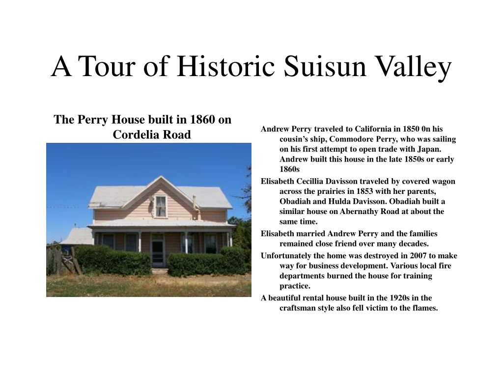
The Perry House built in 1860 on Cordelia Road Andrew Perry traveled to California in 1850 0n his cousin’s ship, Commodore Perry, who was sailing on his first attempt to open trade with Japan. Andrew built this house in the late 1850s or early 1860s Elisabeth Cecillia Davisson traveled by covered wagon across the prairies in 1853 with her parents, Obadiah and Hulda Davisson. Obadiah built a similar house on Abernathy Road at about the same time. Elisabeth married Andrew Perry and the families remained close friend over many decades. Unfortunately the home was destroyed in 2007 to make way for business development. Various local fire departments burned the house for training practice. A beautiful rental house built in the 1920s in the craftsman style also fell victim to the flames. A Tour of Historic Suisun Valley
The Perry House Visit During a recent video documentary of the history of the home by the Vacaville Heritage Council and Town Cryer Pro Video, We were greeted at the door by Joan Perry dressed in period costume and Clyde Perry. A guided tour provided much personal history of the home and family. Below Joan Perry stands in front of portraits of her ancestors, Andrew and Elisabeth Davisson Perry in the living room.
The Nelson Hill Quarry The earliest Spanish settlement in the Cordelia and Nelson Hill area appears to have been about 1824. Friar Altimira established ranchos that included the Santa Eulalia Mission on Suisun Valley Road. Quarrying operations began on Thomasson Hill near Cordelia in the 1850s. Olivine basalt cobbles from the quarry paved many early streets of San Francisco and almost a hundred years later supplied base rock for Travis Air Force Base runways. Today the quarry is known as Nelson Hill. Nelson Hill Drawing-1800s 1930s ad Nelson Hill in the 1940s
The Mysterious Olla in Nelson Hill For decades, speculation was that the Spanish may have had a rancho or at least an asistencia (branch of a Spanish Mission) in the general area of Nelson Hill. Perhaps some indication of a settlement came to light quite by accident at Nelson’s Hill in 1946. During the process of installing a new loading bin, work came to a sudden halt and an investigation began after bulldozers carving away on the eastern side of the hill uncovered a shallow cave. Local Historian, Rulofson, in an attempt to determine the purpose of what appeared to be a man-made hole, recorded the following notes: “At the site of the Nelson quarry on the eastern side of Bridgeport Hill near Cordelia, while excavating for a loading bin for crushed rock, workmen broke through and discovered a pear-shaped olla or cistern, embedded in the side of the hill. The olla was approximately 8 feet across and at least 10 feet in depth. “The olla was formed from a cement, brownish in color and consisting of sand and small pebbles, and a white cotton-like substance, which appears under a microscope to be minute particles of seashell. “Quarrying operations have been conducted at this site since the early 1850s and there is no knowledge or record of any habitation or structure antedating the quarry operations ... “ In addition, the 1837 diseno (a crude map) that was used to identify the boundaries for Francisco Solano’s land grant clearly shows a cultivated field just east of Nelson Hill. Quite likely, the olla was used to store water for the crops grown there. Rulofson’s son, Myron, posed inside the mysterious olla uncovered in 1946 by quarry operations Today the olla, located above Nelson’s home is a weed covered relic slowly fading into oblivion
Old Town Cordelia The Cordelia Hotel, also known as the Bridgeport Hotel and Pittman Hotel was located at the corner of Pittman Road and Cordelia Road. Nothing remains today. Cordelia wasn’t always called by that name and it was not even in the same place it is today. The original location was about a half-mile from its present location, on the other side of I-80. Today, nothing visible remains to indicate a town was ever there. Waterman believed that a site at the head of Cordelia Slough and its creek would be the best place for a town with facilities to ship farm products. Cordelia Creek, unlike the head of the other waterways, was close to the old Sacramento-Benicia road, which led to the upper Suisun and Green Valleys. Waterman felt there was little risk in his enterprise, since he was under the impression that he held title to all other possible sites and could exclude any competitors. Unfortunately for him, he had not adequately explored the area for other navigable sloughs and creeks with access to the Sacramento River. In 1850, two Americans sailed up Suisun Slough and discovered an island with slightly higher ground. A little later, Captain Josiah Wing sailed to the same island and decided it could also become a shipping point. The original terms of the Suisun Grant, part of which Waterman owned, specified only dry land up to the edge of the marshy areas as the boundaries. Since this piece of property was an island separate and within the Grant surrounded by marsh, it did not legally belong to Waterman. Wing was able to establish an “embarcadero” on his “island” in competition with Cordelia. Its location allowed it to draw on a larger region for commercial and shipping activity since it was five miles closer to Lagoon and Vaca Valleys than Cordelia. Cordelia in 1908
Moile’s Hotel & Cooler Building The Moiles Hotel was located at the corner of Bridgeport and Red Rock Road in Cordelia. Nothing remains of the hotel but its “cooler” building and the barn you see in behind and to the left of the hotel still remain standing. The year 1897 is carved over the door of the cooler.
Cordelia Fire Department The history of the fire service in Cordelia dates back to 1918. A group interested in fire control, mounted two 40 gallon Soda Acid tanks on a pair of wheels. This apparatus was stationed in a shed. In case of fire, local trucks hooked on to it and went to the fire. Percy Neitzel’s “Model T Ford” and Claus Mangels’ Kleiber truck made most of the calls. In 1922 the group, headed by C. J. Lockefers and William Smith, purchased a chassis from the Reo Truck Company. The monies were raised by giving dances, barbecues, and donations from people in the area. The truck was equipped with two 40 gallon Soda Acid Fire extinguishers, complete with valves, a hose reel, and an extra 100 gallons of water. In 1925 the fire department was organized. Harvey Elliott was the first official fire chief. Other members included the Benthin Brothers, Seibes, Glashoffs, Gleasons, Neitzels, Erickson, Kolbert, Dunkers, Goosens, Lynch, Ceredas, Mangels, Guyans, Catrio, and many others. . The first fire house was a building behind Peter Siebe’s General Store. On November 15, 1932 Domonic Cereda, Claus Mangels, and Earl Kolbert sent to the Board of Supervisors and formally established the boundaries of the fire district, and set $.08 cents for the district tax rate. The first directors of the district were Domonic Cereda, Claus Mangels, and Leslie Anderson.
Cordelia Fire Department in Later years In 1931 a new Chevrolet fire truck was built by Leslie Anderson and many others. The monies again were raised by dances, donations, etc. The Fire Department went to fires all over the County, even as far as Monticello, in Napa County On June 20, 1939 a large fire burned the greater part of Cordelia’s businesses, including the Southern Pacific Depot. The need for a vehicle with a larger supply of water was realized, so a Mack truck chassis was purchased. Again Leslie Anderson, William Cereda, and many others, designed and constructed the unit. This one was a 500 gallon capacity tank with a 150 GPM pump and high pressure pump for grass fires. Other units since built include a 1947 Power Wagon, a 1955 Power Wagon a 1959 Dodge tanker, and a 1942 Seagrave pumper. Past chiefs have been Tony Catrio, Percy Neitzel, William Cereda, Tony Ambrose, Karl Sternmler, Virgil Linder and Albert Guyan.
Studer’s/Thompson’s Corner Saloon Julius Studer built and operated a banquet room, bar, and dance hall at “Studer’s Corner” as it came to be known. The same location is known as Thompson’s Corner today. Thompson’s Bar was built in 1902 by Henry Studer after fire destroyed the original structures and is one of the oldest operating bars in Solano County today.
Dunker/Adler Slaughterhouse Adjacent to the Cordelia Fire Station is a portion of the Dunker/Adler slaughterhouse in the early 1900s. Later it became a bar and dance hall. Many modifications were made to the building after the fire of 1939. Today the Pienovi family is in the process of restoring the structure in order to save it from destruction..
Green Valley School site in Cordelia Built in the late 1850’s with a steep pitched roof and two sets of stairs leading up to the two front doors. The girls entered on one side and the boys on the other. The bell tower and the overhanging roof were added many years later. This house replaced the old Green Valley School House ins spite of a vigorous protest by the local residents to the county planners
Original 1850s Site of Cordelia Archibald Ritchie bought a large section of the Suysun (Suisun) Land Grant in 1853. Captain Waterman bought a portion of the property from Ritchie about the same time. The first hamlet of Cordelia was named after Waterman’s wife and had a post office by 1854. Wing was able to establish an “embarcadero” on his “island” in competition with Cordelia. Its location allowed it to draw on a larger region for commercial and shipping activity since it was five miles closer to Lagoon and Vaca Valleys than Cordelia. As the settlement extended eastward from Rockville in the late 1850s, much of the Suisun Valley trade came to Wing’s facility, which soon became known as Suisun City. The original town of Cordelia continued to lose trade. The final death blow was yet to happen. In June 1868, the Central Pacific Railroad bypassed Cordelia, entering Suisun City from Vallejo via Jameson Canyon. In anticipation of the arrival of the railroad, Cordelia was already slowly being abandoned as early as 1862. Bridgeport, named after the birthplace of Captain Waterman’s wife, Cordelia, had already been in the process of building a half- mile south in advance of the arrival of the railroad. A wharf was also constructed, providing the new town with both waterway shipping and rail facilities. When Bridgeport submitted an application for a post office, it was turned down because another town held the same name in Mono County. The town was renamed Cordelia, although many of the original settlers there resented the change and continued to call it Bridgeport.
Rubblestone Stage watering stop/Mangel’s winery Current research has placed the age of this structure in the late 1800s and being used as a stagecoach watering stop, but a recent discovery of the Santa Eulalia Mission site may reveal that it is much older. It may have been part of the mission assistencia that was established in 1824 by Father Altimira. Research is in progress by the Vacaville Heritage Council. This structure has been preserved as a historical site in the Pony Express Business Park parking lot by the developers. Lewis Mangels started his winery here in 1896. (Info date-2007-Vacaville Heritage Council
Santa Eulalia Mission This unique structure was built as part of an assistencia and mission as an extension of the Sonoma Mission in Sonoma in 1824 by Father Altimira. It is located about a thousand feet south of the historic Martin Mansion. Members of the Vacaville Heritage Council discovered the existence of the mission building during research of a baptismal font on the property. They requested that a Cultural Resources Survey be conducted by the Anthropological Studies Center at Sonoma State University. Their finding verified the VHC research in project report no. QZ005-01/07. The mission was preserved when the Canavascini brothers built a wooden addition on top of the original rubblestone structure in 1880 and used the building as a winery until selling it to the present owners in 1905.The structure is unique in that it was the only mission structure built during the Mexican era and is the only one that is at least 80% intact.
Inside the Mission The owners have no intention of selling out to developers because of their interest in preserving Solano County history. This is almost certainly where "Chief" Solano was living at the time of his death in 1850. (Info date 2007-VHC)Giovanni Canevascini purchased the property prior to 1878 but did not build until 1880. Later the property was split and Peter Canevascini built his home on the southern section in 1896. Both structures have been remodeled or rebuilt and most of the original stone foundations have been replaced. The Penovi family purchased the northern section and it became known as the Penovi Winery. Room with Sacrarium sink The Sacrarium sink with drain-hole to the ground
Martin House (aka Stonedene)-1861 Restored 1926-29. Stone construction in style of English manor house; Samuel Martin of Pennsylvania, a farmer, came to California in 1849 and arrived in Suisun Valley in 1850. Original estate 11,000 acres. The Samuel Martin house was built in 1861 using stone cut from local quarries. It was remodeled in 1926-1929 under the direction of Julia Morgan and the enclosed porch was added at that time. This is an excellent example of the Gothic Revival style with its steep pitched roof, projecting eaves and deep set window sill. (Info date-1999-Our Lasting Heritage) The Martins at home in 1870s Adjacent to the Martin house is the Martin-Suisun Historic Park that contains vestiges of an ancient spring that attracted the Suisun Indians to this site. A rock with pecked cup shapes and an extensive bedrock motor complex are evidence of their occupancy
Chief Francisco Solano burial Site This 1930s photo of the Buckeye Tree marked the site where Chief Francisco Solano was buried opposite the Martin House. Today the tree is gone and the site is part of the Solano College Campus. It is marked by a plaque commemorating the location.
New Archaeological Dig at Rockville Corners The location of this current dig is be on the site of Andrew Jackson Perry’s brother, John M. Perry’s Blacksmith shop that existed during the village of Rockville’s halcyon days of the early 1850s. There was also a Indian remains and artifacts from the extensive village that existed in the Rockville area found.
Rockville Corners The town of Rockville consisted of a hotel, saloon, post office, blacksmith shop and several residences at one time. Molino had an adobe near here in 1847 and then Perry built his blacksmith shop in 1851. This was a stage shop and also a stop for the Pony Express. The blacksmith shop that was later owned by Eberle stood south of Rockville Road on Suisun Valley Road. The hotel was a two-story structure with a lobby, dining room, kitchen and family living quarters on the first floor. The rooms were on the second floor and patrons entered them from the upper balcony. The McLaughlins owned the corner saloon and store at the turn of the century and then John Nielsen. During recent renovations part of the old saloon framework was exposed and found to be in excellent condition. Several of the residences set on the hillside at the west end of Rockville, date back well before the turn of the century. Rockville Inn.
Pony Express Stop at Rockville Corners Joe Nardone dedicated the site of the Pony Express station at Rockville in front of Rockville Inn. This photo was taken as he was enroute by bicycle touring the entire trail from Missouri to San Francisco. Jerry Bowen, on the right, drove the chase/support vehicle part of the way
Rockville Corners to Manka’s CornerJohn Henry James House-1882 This two story farm house with a gabled roof and full front porch was built for John Henry James in 1882. In 1912 the property was owned by John and Mary Bauman. Mrs. Bauman began her teaching career at Gomer School and came to Rockville School in 1910 where she taught for many years.
Rockville School Rockville School in 1912 Rockville School today-Nisei Club The first Rockville school stood on the northeast corner of Rockville and Suisun Valley Roads. The new school was built in 1881 and was described by Calvin Webster, school superintendent as a fine two story building with a community hall on the second floor and a fine school on the ground floor. The second floor was removed prior to 1910. The second classroom at the rear was added in 1921 with Mrs. Ruth Sheldon as teacher. The building is now the property of the Suisun Nisei Club and is used as a meeting hall.
Rockville Church Parson’s Home-1854 The Parson’s house was built in 1854 and used as a church and weddings until the church itself was finished. Part of the parsonage was of tip-up construction and the side and floorboards were full one-inch rough sawn redwood of widths from 8 to 18 inches. The entrance was on the north side and now moved to the front when the porch was enclosed. The front angled bay and the crossed gabled roof give indications of the original structure. The Tufa Rock foundation has been replaced with cement. At the turn of the century this was the Dahlstrom Nursery and descendants still occupy the property.
Rockville Church-1856 Rockville Church in 1892 Rockville Church today Designated as State Historical Monument No. 779, the stone chapel was constructed by Joel Price and George Whitley, local stone masons in 1856. The stones were quarried from the hills off of Rockville Road. The first religious services in the area were held at "Clayton's Grove" near Manka's Corner. When the decision was made to build a church, Landy Alford offered 5 acres of land for a church and cemetery. In 1863 the members split into two factions over the slavery issue. The Southerns placed a plaque over the entrance which read "Methodist Episcopal Church South." The Northerns left and started their own church in Fairfield. In 1940 W.P.A. workers the restored the chapel.
Rockville Cemetery The cemetery began in 1851 with the death of Sarah Alford, daughter of Landy Alford. The tombstones reflect the ethnic diversity of the area and tell of the constant changing of cultures. In 1927 the main entrance was constructed by E. Brown of Napa. Many of the family plots are bordered by quarried stone borders or ornate iron fences. In later years some cement borders were used. The entire complex is well maintained. Siebe Abernathy Pittman Pangburn Ramsey Hatch The conflict between the land owners and the squatters reached a high point in the 1860’s when the U.S. Land Office declared Vallejo’s claim to the Suscol Grant invalid. Immediately, the squatters poured onto the Suscol and that resulted in lawsuits, injunctions and shootings. It became especially tense in the Green Valley area. The news of Lincoln’s assassination was received in California on the 16th of April 1865. That afternoon a dispatch was sent to the Benicia Barracks, that the Southerners of Green Valley were having a “Jollification” at Perry Durbin’s home over the glorious news. Immediately, Lt. Col. A.E. Hooker, with a detachment of 21 native California Calvary departed for Green Valley. No demand was made of Ramsey to surrender in the name of the United States and two of the troops were wounded when they broke down the front door. Ramsey had thought that it was a mob of squatters attacking his home. Arrested that night were Ramsey, Stilts, Durbin (Derbin), Harbin, James, LaMoree and the teenage sons of Ramsey, James and Durbin. All were taken to the Benicia Barracks and held to await a court martial. No visitors were allowed and even a lawyer who had obtained a pass from Gen. McDowell was turned back. The trial began in mid-June and Hooker testified that the two wounded cavalrymen and their companions had departed the barracks a month before. After 140 pages of evidence and three days of examination by the prosecution and only one by the defense, a telegraphic dispatch from Gen. McDowell was received ordering that all the prisoners be turned over to Judge Hoffman, U.S. District Judge. Ten minutes after the civil authorities had control of them, they were discharged on taking an oath of allegiance
Baldwin Barn-1864 The only large stone barn known to have been constructed in the Suisun Valley. Like the residences, this was built of finely cut stone quarried locally. There are three arches on the front of the building while on the sides there are diamond shaped windows cut into the rough stone. John Baldwin came to Green Valley Township in 1864 and purchased his ranch and the barn was built soon afterward.
The Hatch Bridge The Hatch Bridge A.T. Hatch owned property on both sides of Suisun Valley Road at this location. Mr. Hatch was involved with the first use of refrigerated cars to ship fruit to the eastern market. Constructed in 1909, this was a typical Steiger designed bridge. F.A. Steiger was the county engineer and responsible for many of the reinforced concrete bridges with the high arched span and rounded corner posts.
Suisun Valley China Town(Scene of a Chinese Massacre in 1930s). East of Suisun Valley Road and south of the Hatch Bridge was the community known as Suisun Valley China Town or “Big Camp.” It was a large community that consisted of several small houses, a number of bunk houses for the single men, a store and temple, a laundry building, fruit sheds, a big stable for horses and a wagon yard. Virtually nothing remains of the original buildings at the site.
Manka’s Farm home-1860s Manka Home in early 1900s Manka Home today Turned posts support the shed roof over the full front porch of this 1860’s ranch house. Built on the “T” plan with a cross-gabled roof and a full side porch on the rear section. In 1877 this property was part of Christley Manka’s 100 acre farm. A number of the owners of the Corners have resided here since then.
Manka’s Corners Barton’s Store was, in the early 1850’s, the center of activity in Upper Suisun Valley. The first school in Suisun was started here when Barton’s daughter began to teach students in the store room behind the store. In the 1860’s the school near Manka’s became known as Suisun Dist. #1. Justice of the Peace, Benjamin Brown, held court at Barton’s Store as early as 1854. The Suisun Masonic Lodge held its first meetings at Armijo’s Adobe and then constructed, in 1855, a two story building next to Barton’s Store. The meeting hall for the lodge was on the upper floor and the lower floor was used as a school room.
Manka’s Corners Today By 1855 Barton had sold an interest in the store to Christley Manka. Manka took over the business in 1859 when Barton moved to Fairfield. Milton Cutler’s Stage stopped at Barton’s Store twice a day on its run from Benicia to Suisun and return. There have been many changes and alterations to the building. In 1905 Luke Milligan added a second floor for a dance hall and boxing room. Many businesses have occupied the building including a general store, meat market, saloon, barber shop, delicatessen and a restaurant.
Waterman House • In 1859, Waterman acquired 17 acres of land which contained improvements valued at $2,500 which can be attributed to the Tengate Waterman House as we know it today. The home has been restored and is occupied. Waterman House and Barn today Original Tengate Road to Waterman’s home-Now walking path
Abernathy Road Gomer School The first school in this area was at Mrs. Wing’s home. Later a school house was built on the corner of the Gomer property. The present school opened 14 March 1900 after the old school house had been destroyed by fire. A few years ago, brainless idiots managed to steal the original bell. A smaller substitute hangs in the belfry today.
4440 Abernathy Road Burned out Abernathy Home The stone Abernathy house burned Aug 4, 1921 Nothing remains of the home today at the site Site of a large stone house that was built for Abernathy in 1865. The structure was destroyed by fire on the 4th of August 1921. The present square house with a deep-set porch was built in 1935 for Mrs. J.C. Sutton.
4303 Abernathy-Davisson House-1850s First Obadiah Davisson house Obadiah Davisson house today A two story farm house built on the “T” plan with a full front porch and a railing on the upper deck. Obediah Davisson arrived in Suisun Valley in 1854 and lived in a small cabin at this site until this home was built in 1865. This house also has a circular staircase like the one in the Perry home on Cordelia Road, and both stairways are the same style as the one in Gen. Vallejo’s home in Sonoma. Obadiah and Hulda Davisson lived out their lives in Suisun Valley and are both buried in the Fairfield Cemetery.
This completes the tour of Suisun ValleyOf course it only represents a small portion of the wonderful history of the Valley and its fascinating stories of the pioneers that were here long before us. Many descendents of those hardy pioneers still live in Solano County and yes, some still occupy the ancestral homes. They also represent the few that will openly protect our historical sites with a passion from development for the future education of those yet to come.