
Uploaded by
sen
0 SLIDES
92 VUES
0LIKES
Alberta Mapping Service: Explore Roads, Weather, and More
DESCRIPTION
Access detailed maps of Alberta showcasing major highways, roads, railways, airports, key locations, and climate data. Get answers to questions about roads, weather conditions, and more.
Download

1 / 0
Télécharger la présentation 
Alberta Mapping Service: Explore Roads, Weather, and More
An Image/Link below is provided (as is) to download presentation
Download Policy: Content on the Website is provided to you AS IS for your information and personal use and may not be sold / licensed / shared on other websites without getting consent from its author.
Content is provided to you AS IS for your information and personal use only.
Download presentation by click this link.
While downloading, if for some reason you are not able to download a presentation, the publisher may have deleted the file from their server.
During download, if you can't get a presentation, the file might be deleted by the publisher.
E N D
Presentation Transcript
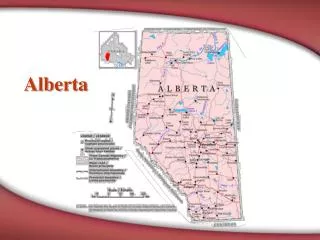
- Alberta Mapping
- Question 1 - 10 Map has major highways, roads, railway tracks, airports and places of interest.
- Answer 1 – 10 Road
- Question 1 - 20 Weather and precipitation conditions prevalant in a region
- Answer 1 – 20 Climate
- Question 1 - 30 Provincial and national boundaries
- Answer 1 – 30 Political
- Question 1 - 40 Features of an area, such as mountains and rivers
- Answer 1 – 40 Physical
- Question 1 - 50 Use of contour lines to highlight the shape and elevation of an area
- Answer 1 – 50 Topographic
- Question 2 - 10
- Answer 2 – 10 Compass rose
- Question 2 - 20 Gives the name or purpose of the map
- Answer 2 – 20 Title
- Question 2 - 30
- Answer 2 – 30 Legend
- Question 2 - 40
- Answer 2 – 40 Symbols
- Question 2 - 50
- Answer 2 – 50 Scale
- Question 3 - 10 Province in yellow
- Answer 3 – 10 Alberta
- Question 3 - 20 Province in yellow
- Answer 3 – 20 British Columbia
- Question 3 - 30 Province in yellow
- Answer 3 – 30 Saskatchewan
- Question 3 - 40 Territory in yellow
- Answer 3 – 40 Yukon
- Question 3 - 50 Province in yellow
- Answer 3 – 50 Ontario
- Question 4 - 10 The distance between Medicine Hat and Lethbridge is about 1.5 centimetres and each centimetre equals 100 kilometres, the number of kilometres between these 2 cities
- Answer 4 – 10 About 150 kilometres
- Question 4 - 20 The distance between Lethbridge and Calgary is about 2 centimetres. Each centimetre equals 100 kilometres. The number of kilometres between these 2 cities
- Answer 4 – 20 About 200 kilometres
- Question 4 - 30 The distance between Calgary and Red Deer is 2 centimetres. Each centimetre equals 75 kilometres. The number of kilometres between these 2 cities is
- Answer 4 – 30 About 150 kilometres
- Question 4 - 40 The distance between Drumheller and Calgary is about 1.5 centimetres. Each centimetre is 75 kilometres. The number of kilometres between these 2 cities is
- Answer 4 – 40 About 110 to 115 kilometres
- Question 4 - 50 The distance from Edmonton to Ft. McMurray is about 8.5 centimetres. Each centimetre is 50 kilometres. The number of kilometres between these 2 cities are
- Answer 4 – 50 About 425 kilometres
- Question 5 - 10 The direction to travel from Taber to Brooks
- Answer 5 – 10 N or North
- Question 5 - 20 The direction you go travelling from Medicine Hat to Pincher Creek
- Answer 5 – 20 SW or South West
- Question 5 - 30 In what direction do you go if you travel from Stettler to Hanna
- Answer 5 – 30 SE or South East
- Question 5 - 40 In what direction do you go if you travel from Alberta to the Yukon
- Answer 5 – 40 NW or North West
- Question 5 - 50 In what direction would you go if you travelled from Edmonton to Ottawa
- Answer 5 – 50 SE or South East


More Related