Download
1 / 1
10 likes | 129 Vues
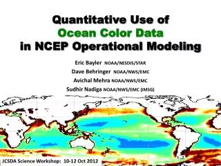
NOAA CoastWatch Okeanos Ocean Color Operational Production System Banghua Yan 1 , Banghua.Yan@noaa.gov I. Simpson 2 , E. Rodriguez 2 , D. Van Pelt 2 , S. Spangler 2 , and A. Irving 1

E N D
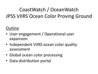
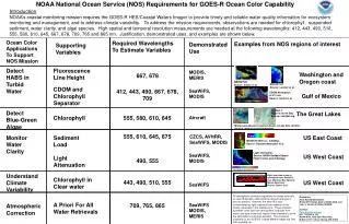
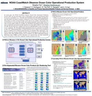
NOAA CoastWatchOkeanos Ocean Color Operational Production System Banghua Yan1, Banghua.Yan@noaa.gov I. Simpson2, E. Rodriguez2, D. Van Pelt2, S. Spangler2, and A. Irving1 1. NOAA/NESDIS/Office of Satellite and Product Operations/Satellite Products and Services Division 2. SSAI T.33 • NOAA Okeanos Ocean Color Operational Products ABSTRACT In recent years, the NOAA CoastWatchOkeanos Ocean Color Operational Production System (OPS) has been providing a series of high quality ocean color operational products for our user communities, e.g., 1 km daily and bi-monthly mean chlorophyll concentrations, and chlorophyll concentration anomaly compared to 61-day averages from MODIS/AQUA. The products of remote sensing reflectance at 667 nm are also available. The products have been beneficial in assessing water quality and tracking potentially harmful algal blooms in order to protect public health. For example, the chlorophyll concentration product has been used to understand and predict harmful algal blooms in the Gulf of Mexico by the NOAA CO-OPS. Recent efforts also continue to provide more MODIS/AQUA ocean color products to user community. The chlorophyll frontal operational products are expected to be available in June 2013. Operational products of Global Emilianiahuxleyi (Ehux) bloom distribution may be available in 2013 if NOAA operational users are identified. More importantly, a new NOAA ocean color products Quality Assurance (QA) monitoring tool is also added to the Okeanos OPS. Many MODIS products will be extended to the NPP Visible/Infrared Imager Radiometer Suite (VIIRS) in 2014. Therefore, it is expected that our future operational ocean color product system offers additional valuable information for users. • Satellites: Moderate Resolution Imaging Spectroradiometer (MODIS) • Instruments: AQUA (Primary) and TERRA (Backup) • Product Specifications • Products: daily merged chlorophyll concentration (Chl-a) and remote sensing reflectance (Rrs667) ; • bi-monthly (monthly) mean Chl-a and Rrs667; daily anomaly of Chl-a and Rrs667; daily Kd490 • Coverage: Northeast (NE), Southeast (SE), Gulf of Mexico (GOM), Caribbean (CB), West Coast (WC), Alaska (AK), East Tropical Pacific (EP), Equatorial Atlantic (EA), Great Lakes (GL), Hawaii (HI), • North Atlantic (NA), and Pacific Basin (PB) • Format: HDF 4.1, GeoTiff, PNG • Horizontal Resolution: 1 km • Timeliness: 12 hours • Algorithms: NASA NIR and NOAA NIR-SWIR • Data Access: ftp://cw-okeanos.noaa.gov/pub/modis/ Examples of products are shown in Figures 2(a) -(f). • NOAA Okeanos (v3.0) Ocean Color Operational Production System 2(c) New algal growth (Positive Chlorophyll Concentration Anomaly) 2(b) Bimonthly-mean Chlorophyll Concentration 2(a) Daily Chlorophyll Concentration Okeanos (v3.0) Ocean Color Operational Production System (Yan and Weng 2007) 2(e) Suspended Sediment Proxy (Remote Sensing Reflectance at 667 nm) 2(f) Water Turbidity(Diffuse Attenuation Coefficient at 490 nm) 2(d) Chesapeake Bay Daily Chlorophyll Concentration • Upcoming NOAA OkeanosOcean Color Operational Products • Satellite/Instrument:MODIS/AQUA • Chlorophyll Frontal Products: • Name: Daily merged chlorophyll front (magnitude and direction) • Coverage: NE, SE, GM, CB, WC, AK, GL, EP, and HI) • Format: GeoTiff, PNG, NetCDF4 • Horizontal Resolution: 1 km • Temporal Resolution: Daily • Timeliness: 12 hours • Data Access: ftp://cw-okeanos.noaa.gov/pub/FRONTAL_data_experimental/ • Ehux Bloom Products: • Name: Global Ehux bloom and calcite concentration • Coverage: Global • Format: GeoTiff, PNG, NetCDF4 • Horizontal Resolution: 4 km • Time Resolution: 8 Days • Data Access: ftp://cw-okeanos.noaa.gov/pub/EHUX_data_experimental/ • Examples of MODIS/Aqua chlorophyll front (magnitude). • Ehux bloom presence/absence and calcite products are • shown in Figures 3(a) – 3(c). Figure 1. The NOAA Okeanos Ocean Color Operational Production System (OPS) Flow Chart. • Developmental Okeanos Ocean Color Products QA Monitoring Tool Examples: Monitoring NIR-SWIR Bi-Monthly Chlorophyll Products 3(a) Chlorophyll Front (Magnitude) 3(b) 8-Day Composite Global Ehux Bloom Map 3(c) 8-Day Composite Global Calcite • Other Contributors: STAR CoastWatch Team led by Kent Hughes (CWAPS developer); NASA's Ocean Biology Processing Group (NASA L2gen Alg.); • . M. Wang (NOAA NIR-SWIR Alg.); C. Brown (Ehux and Calcite Alg.); I. Belkin (Chlorophyll Front Alg.). • Acknowledgements: Thanks to M. Hopkins, C. Brown and N. Parsons for development, and L. Stathoplos and R. Lindsay for operational deployment of the Okeanos v2.0 system.