Download
1 / 42
420 likes | 469 Vues
This paper discusses contributions to decision support for maritime situation awareness and threat detection in the context of piracy. It explores the definition of piracy, where it takes place, and the scale of the piracy problem. It also examines the European Naval Force's operation in the area and the importance of timely and comprehensive maritime situation awareness for effective decision support.

E N D
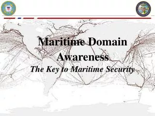
Contributions to decision support for maritime situation awareness and threat detection Joachim Biermann Head Research Group Threat Detection Dept. Sensor Data and Information Fusion Fraunhofer Institute for Communication, Information Processing and Ergonomics NATO ASI 2011, Salamanca, Spain, 19-30 September, 2011
What is piracy? • “Maritime piracy consists of any criminal acts of violence, detention, rape, or depredation committed for private ends by the crew or the passengers of a private ship or aircraft that is directed on the high seas against another ship, aircraft, or against persons or property on board a ship or aircraft.” “ .. in and out the jurisdiction of any state.. “(United Nations Convention on the Law of the Sea (UNCLOS) of 1982, http://en.wikipedia.org/wiki/Piracy#Definition 18.9.2011) • “Piracy includes all acts of violence against ships, her crew and cargo. This includes armed robbery and attempts to board and take control of the ship, wherever this may take place.” • (EUNAVFOR)
Where does piracy take place? • Littoral sea • Narrow passages • Open sea • National territory • International open sea • Underway • Anchoring • waiting for being processed or new contract • at berth e.g. at an oil platform Image: The Royal Society/Gastner
Scale of today’s piracy problem - some facts* • In 2010 • Pirates • captured 1181 people • hijacked 53 ships • In 2011(status 28.3.2011) • Somali pirates have • hijacked 13 ships, • taken 243 hostages • killed 7 people • Currently they hold 33 vessels and 711 hostages. • (according to the latest available IMB figures) More than in any year since the International Maritime Bureau (IMB) has kept records. Somali pirates were responsible for nearly all of these ship seizures. *http://www.lloyds.com/News-and-Insight/News-and-Features/Geopolitical/Geopolitical-2011/Piracy-High-crime-on-the-high-seas
EUNAVFOR UPDATED FACTS & FIGURES • The European Naval Force operates in an Area of Operations covering the southern Red Sea, the Gulf of Aden and a large part of the Indian Ocean, including the Seychelles. • This is an area 1.5 the size of Europe mainland. • EU NAVFOR warships EU NAVFOR aircraft • SPS INFANTA CRISTINA Spain P-3A ORION Spain • SPS GALICIA Spain FAIRCHILD MERLIN Lux • NLMS ZUIDERKRUIS Netherlands • FS SURCOUF France • FGS BAYERN Germany • FGS KÖLN Germany Pictures and info from MEDIA INFORMATION GUIDE www.eunavfor.eu 21.9.2011
European Union Naval Force (EU NAVFOR) • European Union Naval Force (EU NAVFOR) Somalia Operation ATALANTA • Mandate is to: • • Protect vessels of the World Food Programme (WFP), humanitarian aid, and African Union Mission in Somalia (AMISOM) shipping • • Help deter, prevent and repress acts of piracy and armed robbery • • Protect vulnerable shipping • • Contribute to monitoring fishing activities off the coast of Somalia
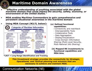
Counter Piracy • Objective • To deter, prevent and repress all acts of piracy • Preconditions • Timely and comprehensive maritime situation awareness (MSA)Questions on board a ship at sea in High Risk Areas (Request for information) • Are there pirates in this area? • Where are they now? • When have they been active lately? • What are their actual activities and intentions? • Ability to react on evolving threats
MSA as precondition to decision support • Collection of all relevant data and information • Physical surveillance of the area by an appropriate sensor suite • Detection, tracking and classification of suspicious objects • Elicitation of additional information concerning the general and actual context of the situation under observation • Processing of all incoming data and information to produce a proper picture of the situation • Assessment of the determined situation on the background of situation context in general and known actual facts • This defines basic steps in the production of Intelligence
Observation OODA Action Orientation Loop CCIR+PIR Direction Decision Intelligence Perceived Situation Dissemination Collection Cycle Targeting Processing Intelligence Cycle Interfacing the OODA Loop
Broadening the scope of view • “Understanding” piracy as an underlying long term political problem and objective for intelligence in counter piracy • Who are the pirates? • Why are they pirates • How is piracy organised? • How is piracy conducted? • How do they know that a worthwhile ship approaches? • What happens after the encounter? • Who e.g. negotiates about the ransom?
Local operating forces at theatre police coast guard national maritime forces international maritime forces captain of target vessels ….. Interest groups operating in background intelligence services chatters insurance companies (e.g. Lloyds) security groups Interpol FRONTEX IMB ….. Who is producing intelligence? • Who’s OODA loop and Intelligence Cycle is relevant? • Who contributes to the development of Situation Awareness?
Direction Intelligence Dissemination Collection Cycle Processing The role of military intelligence • Intelligence provides the commander with • a situational picture • an assessment of his adversaries’ capabilities • a judgement of their most likely tactics • a prediction of their intentions • an assessment of the effects of the environment on both own and hostile operations
Capability Opportunity Necessary preconditions for piracy • Material & personnel requirements • Personnel • Group structure and organisation • Expert knowledge (training, experience) • Equipment • Armament • Transportation and logistics • Communications • Space & terrain attributes • Defilade of path of approach • Suitability of location • Distance of operation location • Accessibility of location • Time constraints • Reachability Reference: BMP4 Best Management Practices for Protection against Somalia Based Piracy , Version 4 August 2011, EUNAVFOR
Pirate capabilities • Equipment • BOATSCommonly, two small high speed (at least 25 knots) open boats or ‘skiffs’ are used in attacks. Skiffs are frequently fitted with 2 outboard engines or a larger single 60hp engine often approaching from either quarter or the stern. • WEAPONS • Automatic guns • Rocket propelled grenades (RPG) Personnel • In action: recruited former fishermen, growing experience in piracy • In background: criminal organisations, terrorist groups?, ..?
Typical course of action of a piracy attack • Is there a known SOP of pirates conducting an encounter? • Tactics • Approach stagePirates generally do not use weapons until they are within two cables of a vessel, therefore any period up until this stage can be considered as “approach” • Attack stage • Closing up to the vessel placing their skiffs alongside (Somalia) • Starting to shoot esp. to the bridge to force the vessel slowing down • Boarding with ladders, ropes, or a long hooked pole with a knotted climbing rope to climb up the side of the vessel. • Getting access to the bridge
How can we intervene to piracy? • Intent Financial advantage Board a vessel for robbery or ransom • Capability Attack boat • Opportunity Depending on pirate’s SA (disc. by Alan) • (e.g. weather, sea state <= 3, distance,..) • Question: What can do best to prevent an encounter? • Answer: Improved ISR for optimal SA
Information collection • Which information sources are available to detect possible threats? • additional information • port entries information • port security systems • Jane’s • Office of Naval Intelligence (ONI) • Lloyd’s • public information • News agancies • Web • …. • Automatic Identification System (AIS) (public,”real time”) • Vessel Traffic Managementsystem (VTM) • Long range identification andtracking (LRIT) • Global Monitoring for Environment and Security (GMES) • Coastal radar • Vessel radar • Airborne radar / EO • UAVs radar / EO
Requirements for ISR systems against piracy • Permanent and all-weather coverage of maritime areas (blue border, shoreline, shipping facilities) with an appropriate scope of sensors • Continuous collection and fusion of heterogeneous data provided by various types of deployed sensors and other intelligent information from external information sources • Supervised automatic detection of abnormal spatial-temporal vessel behaviours, identification of risks and threats and documented alarming • Smart integration into existing security systems • Human-machine system concepts ensuring situation awareness during supervision and handling of complex dynamic information; covering, e.g., user support / assistance, alarm management, multi-modal interaction, user adaptation, vigilance monitoring
External DBs External DBs External DBs Local Control Center n Data- and Information Fusion, asset monitoring, sensor (re-)directing, local / tactical (re-)action Local Control Center 1 Data- and Information Fusion, asset monitoring, sensor (re-)directing, local / tactical (re-)action MSD(loc/reg/nat) MSD(loc/reg/nat) Trans L0-L1 Trans L0-L1 Trans L0-L1 Trans L0-L1 Trans L0-L1 Trans L0-L1 Trans L0-L1 Trans L0-L1 Trans L0-L1 Trans L0-L1 GSM GSM RADAR RADAR AIS AIS SAT SAT LRIT LRIT Information Fusion Architecture Level P0 – P2/3 Regional / national Control Center Data- and Information Fusion L2 Data, operational (re-)action, policy, strategy P2/3: regional / national control MSD(loc/reg/nat) ….. P1: local control P0: Sensors / Platforms Platform DB Platform DB Platform DB Platform DB Data stream Direct communicatiom with neighboring agencies Control stream
External DBs External DBs External DBs Information Processing Architecture Level P2/3 - P4 International Control Center Data- and Information Fusion L2 /L3 & L4 Data, coordination (re-)action, policy, strategy P4: EU integrated multinational control MSD(nat/EU) Regional / national Control Center 1 Data- and Information Fusion L2 Data, operational (re-)action, policy, strategy Regional / national Control Center m Data- and Information Fusion L2 Data, operational (re-)action, policy, strategy …. P2/3: regional / national control MSD(loc/reg/nat) MSD(loc/reg/nat) Local Control Center Local Control Center Local Control Center Local Control enter Data stream Control stream
EUCC NationalControl Centres RegionalControl Centres Local Assets(VTS-Centres, CG, Navy) Requirements for the ISR-System Architecture • Vertical & horizontal information exchange and operational control across national & regional borders • Exploitation of innovative techniques (sensors, analysis, communication) • Best possible support and situation awareness on all hierarchy levels • Local operation control & central coordination (“Power to the edge”)
Examples of advanced sensor technologies to be developed • Surveillance and reconnaissance by exploitation multi- sensor and multisource data and information • Exploiting wide-area surveillance data bases for anomaly detection • Object detection and tracking by passive radar • SIGINT/ELINT localization/detection and tracking of pirate cell phone communication • Multiple sensor copter for anomalous activity detection and alerting
Examples for Anomalies • Peculiarities in velocity or acceleration: Fisher boats are slower and less agile than speed boats. • Heading, aspect angle: Objects heading in a certain direction or coming from a certain direction (from a foreign country, towards a vulnerable target) • Common history: Objects that share a path may belong together • Rare events: Vessel far out of sea lane at unusual time at unusual place
Establishment of Patterns of Normality and Detection of Anomalies Extracted pattern of default behaviour superimposed by “standard ” und “abnormal” trajectory Statistical data for ship traffic lines Battistello, G., Ulmke, M.: Exploitation of a priori Information for Tracking Maritime Intermittent Data Sources, International Conference on Information Fusion 2011, Chicago
Tracking using a relational database Motivation: • Efficient access methods of a DBMS to manage the large amount of data (e.g. 200-300 plots every 2 seconds) • Synchronizing streams of data coming from different sensors • Robustness against system failures (“recovery”) • Allows synchronized multi-user access for pursuing determined tracks • Persistent storage of sensor data is often indispensable, e.g. inmilitary scenarios
Fusion of high and low level information for Situation Awareness IN a data base • Store sensor data and context information in a DB • Fusetracking data and context information via specialSQL views. Sensor 1 Client 1 Plots etc. Sensor 2 O U T P U T I N P U T context DBMS Client 2 Context 1
Example: Data stream analysis Relation between track data and context information within the same continous SQL request Which aircrafts are in landing approach?
Benefits of fusion in a data base • Beyond the pure kinematical state, tracking data provide additional information for classifying objects and situations. • Classification can be made by pattern analysis or by augmenting tracks with context data. • Classification allows for building situation awareness systems. • Employing a relational database provides a flexible tool for handling sensor data streams and context data.
GSM Illuminators for Covert Observation • Advantages • In general many illuminators available, little coverage problems in urban areas • In general separation of illuminators by frequency, i.e. no ghosts • Better suited radar frequency 1.8GHz (L-band, angular resolution improved by factor 6) • Disadvantages • Low transmit power (~10W, short range coverage) • Fairly low bandwidth (bad range resolution) • Disadvantages can be overcome by • Long integration time • Fusion of multiple bistatic systems (illuminators)
GSM coverage maps http://www.gsmworld.com.www.mobileworldlive.com/maps
Experimental System GAMMA-2 for PCL Linear array with 16 elements Separable into two blocks of 8 elements
PCL Radar Range for Detection using GSM / GAMMA-2 Planned field exp. 2011/2012
Improvement of localization by sensor data fusion Antenna array: Measures radio signals Unique Inaccurate Camera: Not measuring radio signals Ambiguous Accurate • Aim: • Localize an unknown number of emitters with bearing measurements • Improvement of the results by fusing data of heterogeneous sensors • Used sensors:
Localisation & Tracking: surveyed UAVs LUNA EuroHawk manned UAV demonstrator Smaragd NEO (19. August 2010) BARRACUDA UUV at NURC, La Spezia
Field trials for emitter localization with UAS Spatzenhausen (July 2008) • Live-demonstration: • Bearing and localization with UAS LUNA emitters LUNA (with flight course)
SIGINT-IMINT-Radar-E/O-Fusion: Potential Class/ID: radiation + image: platform, object, vessel, boat radiation + radar: collective motion, convoys radiation + context: approach to critical points Impact: cross-cueing and sensor management improved target geo-location improved data-to-object association improved detection, identification confidence awareness: improved visualisation Products: event recording & documentation (juridical; forensic) continuous tracks from segments assistance for anomaly detection traffic flow, object interrelation analysis
Dimensions of influencing Pirates • Intent Take activities to make them leave this “business” area Political, social and economic dimension (strategic) • Capability “Technical” aspects of the problem; of minor influence to a stable solution. E.g. Intervene on availability of weapons • Opportunity Improved SA and Decision Support System First step activity to prevent current threat; working on the symptoms of the underlying problem (tactical) • Pirate’s Solution approach
Summary 1 • What can be done to prevent and deter piracy? • Two levels of the problem • Activities and reaction in the high risk areas for piracy • To cope with the underlying social / political problem of piracy • Ad 1. To deal with level 1, the tactical level, means to react to current threats but piracy in general will not stop • Ad 2. To deal with level 2, the strategic level, aims at finding a more general solution at the root of the problem.
Summary 2 • All activities concerning in-theatre solutions need an optimal tactical Situation Awareness (SA) • Therefore it is required to have best ISR conditions • Comprehensive area surveillance providing sensor data on vessel activities (hard data) • Context information on the scenario and its background to better understand the activity picture derived from the sensor data (soft data) • Algorithms to exploit hard and soft information in a holistic manner • Human centric transnational decision support system
? Questions? Cuestiónes? Questions? Domandi? Вопрос?