Download
1 / 23
230 likes | 379 Vues
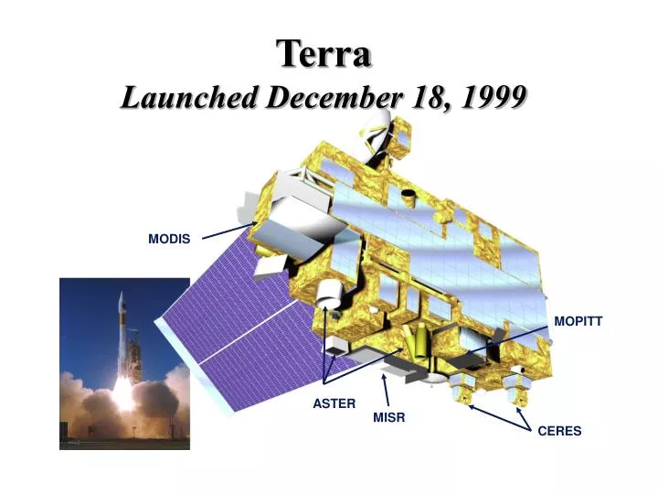
Terra Launched December 18, 1999. MODIS. MOPITT. ASTER. MISR. CERES. Advanced Spaceborne Thermal Emission & Reflection Radiometer (ASTER). NASA & MITI, Terra 705 km polar orbit, descending (10:30 a.m.) Sensor Characteristics 14 spectral bands ranging from 0.56 to 11.3 µm

E N D
TerraLaunched December 18, 1999 MODIS MOPITT ASTER MISR CERES
Advanced Spaceborne Thermal Emission & Reflection Radiometer (ASTER) • NASA & MITI, Terra • 705 km polar orbit, descending (10:30 a.m.) • Sensor Characteristics • 14 spectral bands ranging from 0.56 to 11.3 µm • 3 tiltable subsystems for acquiring stereoscopic imagery over a swath width of 60 km • Spatial resolutions: • 15 m (bands 1, 2, 3N, 3B) • 30 m (bands 4 - 9) • 90 m (bands 10 - 14) • 4% reflectance calibration accuracy (VNIR & SWIR) • 2 K brightness temperature accuracy (240-370 K) VNIR (1,2,3N) VNIR (3B) TIR SWIR
Synergy Between Terra & Landsat-7 (same day 705 km orbits ~ 30 min. apart) Landsat ETM+ input to Terra data • Vegetation classification for MODIS & MISR biophysical products • Focus on global change hotspots detected by MODIS & MISR • Linking Terra observations with 26+ year Landsat archive • Radiometric rectification of MODIS data 2330 km swath width MODIS spatial resolution (250, 500, 1000 m) global coverage ˛ 2 days MISR 360 km spatial resolution (275, 550, 1100 m) global coverage ˛ 9 days 16 day orbital repeat global coverage ˛ seasonally Landsat 7 183 km spatial resolution (15, 30, 60 m) 45-60 day orbital repeat global coverage ˛ months to years ASTER spatial resolution (15, 30, 90 m) 60 km swath Terra input to Landsat ETM+ data • Use of MODIS & MISR for improved atmospheric correction of ETM+ • Use of MODIS & MISR for temporal interpolation of ETM+ data • Cross-calibration of ASTER, MISR, and MODIS
Spectral Exitance (Temp. & e) = 1.0 = 1.0 = 1.0
Exoatmospheric Solar Irradiancel Solar Irradiancel at Earth’s Surface atmospheric limb
TerraLaunched December 18, 1999 MODIS MOPITT ASTER MISR CERES
Advanced Spaceborne Thermal Emission & Reflection Radiometer (ASTER) • NASA & MITI, Terra • 705 km polar orbit, descending (10:30 a.m.) • Sensor Characteristics • 14 spectral bands ranging from 0.56 to 11.3 µm • 3 tiltable subsystems for acquiring stereoscopic imagery over a swath width of 60 km • Spatial resolutions: • 15 m (bands 1, 2, 3N, 3B) • 30 m (bands 4 - 9) • 90 m (bands 10 - 14) • 4% reflectance calibration accuracy (VNIR & SWIR) • 2 K brightness temperature accuracy (240-370 K) VNIR (1,2,3N) VNIR (3B) TIR SWIR
Synergy Between Terra & Landsat-7 (same day 705 km orbits ~ 30 min. apart) Landsat ETM+ input to Terra data • Vegetation classification for MODIS & MISR biophysical products • Focus on global change hotspots detected by MODIS & MISR • Linking Terra observations with 26+ year Landsat archive • Radiometric rectification of MODIS data 2330 km swath width MODIS spatial resolution (250, 500, 1000 m) global coverage ˛ 2 days MISR 360 km spatial resolution (275, 550, 1100 m) global coverage ˛ 9 days 16 day orbital repeat global coverage ˛ seasonally Landsat 7 183 km spatial resolution (15, 30, 60 m) 45-60 day orbital repeat global coverage ˛ months to years ASTER spatial resolution (15, 30, 90 m) 60 km swath Terra input to Landsat ETM+ data • Use of MODIS & MISR for improved atmospheric correction of ETM+ • Use of MODIS & MISR for temporal interpolation of ETM+ data • Cross-calibration of ASTER, MISR, and MODIS
ASTER Stereo View of Mt. Fuji Flyby around Mt. Fuji, was created entirely from ASTER data It shows how ASTER’s stereo imaging capability allows us to produce detailed elevation data Over the lifetime of the mission, ASTER will acquire stereo data over the entire land surface of the Earth
ASTER Image of San Francisco Bay • Visible & Near-Infrared Radiometer • R = 0.81 µm • G = 0.66 µm • B = 0.56 µm • Suspended sediment in the bays, vegetation health, and details of urban development
ASTER Image of Washington R = 0.81 µm G = 0.66 µm B = 0.56 µm
Summary and Conclusions • High spatial resolution sensors have been in orbit around the Earth since 1972 and is a useful resource for • Land cover and land use change • Emergencies such as flooding and volcanic eruptions • Monitoring the evolution and change in glaciers and ice sheets over time Combination of sensors/spectral regions is powerful and redundancy is v. important