Download
1 / 10
100 likes | 349 Vues
Magnitude 7.1 NEAR THE EAST COAST OF HONSHU, JAPAN Thursday, April 7, 2011 at 14:32:41 UTC. Japan was rattled by a strong aftershock and tsunami warning Thursday night nearly a month after a devastating earthquake and tsunami flattened the northeastern coast.

E N D
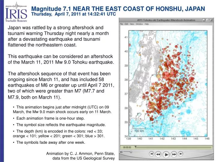
Magnitude 7.1 NEAR THE EAST COAST OF HONSHU, JAPANThursday, April 7, 2011 at 14:32:41 UTC Japan was rattled by a strong aftershock and tsunami warning Thursday night nearly a month after a devastating earthquake and tsunami flattened the northeastern coast. This earthquake can be considered an aftershock of the March 11, 2011 Mw 9.0 Tohoku earthquake. The aftershock sequence of that event has been ongoing since March 11, and has included 58 earthquakes of M6 or greater up until April 7 2011, two of which were greater than M7 (M7.7 and M7.9, both on March 11). • This animation begins just after midnight (UTC) on 09 March, the Mw 9.0 main shock occurs early on 11 March. • Each animation frame is one-hour step. • The symbol size reflects the earthquake magnitude. • The depth (km) is encoded in the colors: red < 33; orange < 101; yellow < 201; green < 301; blue > 301. • The symbols fade away after one week. • Animation by C. J. Ammon, Penn State, • data from the US Geological Survey
Magnitude 7.1 NEAR THE EAST COAST OF HONSHU, JAPANThursday, April 7, 2011 at 14:32:41 UTC This major earthquake occurred Thursday at 11:32:41 PM local time off the east coast of Honshu about 66 kilometers (30 miles) east of Sendai. Both the great M9.0 earthquake of March 11 and this M7.1 event occurred on this plate boundary. In this figure, the earthquake (yellow star) is plotted with regional historical seismicity since 1990. This historic seismicity map shows that earthquakes occur at increasing depths from east to west as the Pacific Plate subducts beneath Japan. M7.1 April 7 Image courtesy of the US Geological Survey
Magnitude 7.1 NEAR THE EAST COAST OF HONSHU, JAPANThursday, April 7, 2011 at 14:32:41 UTC Plotted are earthquakes in 2011 in the northern Honshu region as determined by the US Geological Survey National Earthquake Information Center. The red star indicates the epicenter of the M7.1 earthquake while the large red circle shows the epicenter of the March 11 M9.0 great earthquake that generated the tsunami that devastating northern Honshu and caused damage across the Pacific Ocean Basin. The April 7 earthquake is within the distribution of aftershocks that have occurred since the March 11 great earthquake and can be considered a major aftershock of the great earthquake. M9.0 March 11 M7.1 April 7 Image courtesy of the US Geological Survey
Magnitude 7.1 NEAR THE EAST COAST OF HONSHU, JAPANThursday, April 7, 2011 at 14:32:41 UTC Aftershock sequences follow predictable patterns as a group, although the individual earthquakes are themselves not predictable. The graph below shows how the number of aftershocks and the magnitude of aftershocks decay with increasing time since the main shock. The number of aftershocks also decreases with distance from the main shock. It is notable that this aftershock is unusually large considering that it occurred four weeks after the main shock. A M7.9 aftershock and a M7.7 aftershock occurred about 30 minutes and 40 minutes after the M9.0 main shock, respectively, but no subsequent aftershocks have been in the magnitude 7 range until today’s M7.1 earthquake. Image and text courtesy of the US Geological Survey
Magnitude 7.1 NEAR THE EAST COAST OF HONSHU, JAPANThursday, April 7, 2011 at 14:32:41 UTC Shaking intensity scales were developed to standardize the measurements and ease comparison of different earthquakes. The Modified-Mercalli Intensity scale is a twelve-stage scale, numbered from I to XII. The lower numbers represent imperceptible shaking levels, XII represents total destruction. A value of IV indicates a level of shaking that is felt by most people. Perceived Shaking Extreme Violent Severe Very Strong Strong Moderate Light Weak Not Felt Modified Mercalli Intensity Image courtesy of the US Geological Survey USGS Estimated shaking Intensity from M 7.1 Earthquake
Magnitude 7.1 NEAR THE EAST COAST OF HONSHU, JAPANThursday, April 7, 2011 at 14:32:41 UTC USGS PAGER Population Exposed to Earthquake Shaking The USGS PAGER map shows the population exposed to different Modified Mercalli Intensity (MMI) levels. MMI describes the severity of an earthquake in terms of its effect on humans and structures and is a rough measure of the amount of shaking at a given location. Overall, the population in this region resides in structures that are resistant to earthquake shaking. The color coded contour lines outline regions of MMI intensity. The total population exposure to a given MMI value is obtained by summing the population between the contour lines. The estimated population exposure to each MMI Intensity is shown in the table below. Image courtesy of the US Geological Survey
Magnitude 7.1 NEAR THE EAST COAST OF HONSHU, JAPANThursday, April 7, 2011 at 14:32:41 UTC This earthquake was the result of thrust faulting along or near the convergent plate boundary where the Pacific Plate subducts beneath Japan. This map shows the rate and direction of motion of the Pacific Plate with respect to the Eurasian Plate near the Japan Trench. The rate of convergence at this plate boundary is about 83 mm/yr (8 cm/year). This is a fairly high convergence rate and this subduction zone is very seismically active. Japan Trench
Magnitude 7.1 NEAR THE EAST COAST OF HONSHU, JAPANThursday, April 7, 2011 at 14:32:41 UTC At the latitude of this earthquake, the Pacific Plate moves approximately westwards with respect to the Eurasian Plate at a velocity of 83 mm/yr. The Pacific Plate thrusts underneath Japan at the Japan Trench, and dips to the west beneath Eurasia. The epicenter and focal-depth of the April 7 earthquake are consistent with the event having occurred very close to the main interface thrust-fault of the subduction zone plate boundary. Analysis from the USGS states that “preliminary focal-mechanisms, however, imply slip on a fault with steeper dip than that of the main interface thrust-fault, which may imply an intraplate source is more likely. “ Shaded areas show quadrants of the focal sphere in which the P-wave first-motions are away from the source, and unshaded areas show quadrants in which the P-wave first-motions are toward the source. The dots represent the axis of maximum compressional strain (in black, called the "P-axis") and the axis of maximum extensional strain (in white, called the "T-axis") resulting from the earthquake. USGS Centroid Moment Tensor Solution
Magnitude 7.1 NEAR THE EAST COAST OF HONSHU, JAPANThursday, April 7, 2011 at 14:32:41 UTC The record of the M7.1 earthquake that occurred near the east coast of Honshu, Japan on the University of Portland seismometer (UPOR) is illustrated below. Portland is about 7481 km (4648 miles, 67.4°) from the location of this earthquake. PP waves are compressional waves that bounce off the Earth’s surface halfway between the earthquake and the station. PP energy arrived 13 minutes and 19 seconds (799 seconds) after the earthquake. S and SS are shear waves that follow the same path through the mantle as P and PP waves, respectively. The S waves arrived 19 minutes and 42 seconds (1182 seconds) and SS waves arrived 24 minutes and 4 seconds (1444 seconds) after the earthquake. Surface wave energy required approximately 28 minutes and 30 seconds (1710 seconds) to travel the 7481 km (4648 miles) around the perimeter of the Earth from Japan to Portland, Oregon. Following the earthquake, it took 10 minutes and 50 seconds (650 seconds) for the compressional P waves to travel a curved path through the mantle from Japan to Portland.
Magnitude 7.1 NEAR THE EAST COAST OF HONSHU, JAPANThursday, April 7, 2011 at 14:32:41 UTC 3 components recorded by A04D (0.01–0.07 Band Pass (BP) filtered), the closest USArray station to the event. A04D