Enhancing Geospatial Interoperability: FGDC GAI Geospatial Interoperability Reference Model (GIRM)
The FGDC GAI Geospatial Interoperability Reference Model (GIRM), developed by the FGDC Geospatial Applications and Interoperability Working Group, serves as a vital tool for promoting geospatial interoperability. Approved on June 5, 2001, it outlines a structured approach for the development and maintenance of interoperable systems, providing essential evaluation criteria and guidelines. The model facilitates effective communication between diverse software systems and services, making it invaluable for various stakeholders in the geospatial community. More details and public drafts are available online.

Enhancing Geospatial Interoperability: FGDC GAI Geospatial Interoperability Reference Model (GIRM)
E N D
Presentation Transcript
The FGDC-GAI Geospatial Interoperability Reference Model (GIRM) Myra Bambacus John Evans FGDC Geospatial Applications and Interoperability (GAI) Working Group
GAI and the GIRM • Briefed to FGDC and approved on 6/5/01 • Chartered specifically to: • Develop and maintain a reference model to support the development and interoperability of systems providing data and services • Created the GIRM Team • Stipulated Evaluation Criteria / Public Review /Maintenance • Deliberative and Iterative • Lots of Comments • Presentation for Information • It’s not a Standard, Policy, or Mandate • It is a tool to enable Geospatial Interoperability
Overview • Work item of the FGDC Geospatial Applications and Interoperability (GAI) Working Group • Public draft available: http://gai.fgdc.gov/girm • A guide to interoperability of geospatial information systems and services • References (via hypertext) specs & standards from … • ISO (Tech. Comm. 211 on Geomatics) • Federal Geographic Data Committee • OpenGIS Consortium • … and others (EPSG, W3C, etc.) • Summarizes the content of each standard or spec and its relation to others, within a structured model
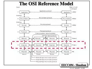
Structure What How • Abstract: theory -- guidance for design • Implementation: practice -- software “recipes” The interoperability “stack” • Data – Services – Applications Levels of abstraction
The interoperability “stack” Access to transformed data Service Chaining Metadata search and retrieval Geoprocessing Services Catalog Catalog Catalogs Metadata update Directdata access Coverages Features Other data Content Repositories Clients User Applications Middleware Servers
Partitioning the “standards space” Features Encoding: OGC GML FGDC SDTS VPF, DIGEST Encoding: OGC GML FGDC SDTS VPF, DIGEST Encoding: OGC GML FGDC SDTS VPF, DIGEST Encoding: OGC GML FGDC SDTS VPF, DIGEST Encoding: OGC GML FGDC SDTS VPF, DIGEST Encoding: OGC GML FGDC SDTS VPF, DIGEST Coverages Interface: Simple Features Access Web Feature Service Interface: Simple Features Access Web Feature Service Interface: Simple Features Access Web Feature Service Interface: Simple Features Access Web Feature Service Interface: Simple Features Access Web Feature Service Interface: Simple Features Access Web Feature Service Metadata Maps Reference Systems Services Content: ISO 19107 (Spatial Schema) ISO 19109 ISO 19110 ISO 19108 Content: ISO 19107 (Spatial Schema) ISO 19109 ISO 19110 ISO 19108 Content: ISO 19107 (Spatial Schema) ISO 19109 ISO 19110 ISO 19108 Content: ISO 19107 (Spatial Schema) ISO 19109 ISO 19110 ISO 19108 Content: ISO 19107 (Spatial Schema) ISO 19109 ISO 19110 ISO 19108 Content: ISO 19107 (Spatial Schema) ISO 19109 ISO 19110 ISO 19108 Behavior: ISO 19125-1 (Simple Features: Common Arch.) Behavior: ISO 19125-1 (Simple Features: Common Arch.) Behavior: ISO 19125-1 (Simple Features: Common Arch.) Behavior: ISO 19125-1 (Simple Features: Common Arch.) Behavior: ISO 19125-1 (Simple Features: Common Arch.) Behavior: ISO 19125-1 (Simple Features: Common Arch.)
Status • Maintained by interagency editorial team • U.S. Federal, industry, etc. • Open to anyone; seeking a broad consensus • Supports FGDC GAI working group • Consultations with agencies developing software • Geospatial One-Stop portal • etc. • Draft (v0.8) was released for public comment • http://gai.fgdc.gov/girm/
Purpose and benefits • Hyperlinks to open interface standards • useful for building / buying interoperable systems • Fits technologies, applications into a “big picture” • Reuse of designs and components • Cogent descriptions and comparisons • Cumulative learning as we go • Guides software development • Curriculum design; marketing & advocacy; etc. • Informs technology decisions • A “meta-specification” for gov’t requirements
Organizing principles • Geospatial topics: Data & Data Access; Metadata & Catalog Access; Maps & Visualization; Geospatial Reference Systems; other Geoprocessing Services. • Viewpoints: Service Invocation vs. Information Transfer • Abstract models vs.Implementation specifications • Evaluation criteria, e.g., • Openness: defined and maintained by an open, voluntary consensus • Maturity: complete and not subject to significant changes • Geospatial Interoperability:enabling different software systems to work together on geospatial topics
Scope • Interoperability among systems and services • Intended context is distributed systems and services over networks • Lists mechanisms that let systems work together (but not policies on info content or presentation) • “Open” specifications – that is, defined and maintained by broad voluntary consensus • Not “de facto” standards • Not government-only standards • Annex B has publicly available “de facto standards” • Mature specifications (adopted or near final) • Annex A has standards proposals • “A tool, not a rule” • No de jure role implied
Where to from here • Address final comments and post v1.0 • Devise a maintenance scheme • http://gai.fgdc.gov/girm