Download
1 / 9
90 likes | 198 Vues
Learn about the innovative RGIS built on open source tech, GSOTRE platform, REST-based web services, and future enhancements at the NMGIC Fall Workshop and Meeting in New Mexico.

E N D
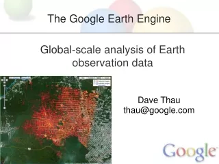
The Open Source Technology behind new RGISNew Mexico Resource Geographic Information SystemOpen Source Technologies • Renzo Sanchez-Silva, Analyst Programmer • Earth Data Analysis Center, UNM 2010 NMGIC Fall Workshop and MeetingAlbuquerque, New Mexico October 2010
RGIS is not a platform, GSTORE is • Introducing the: • Geographic Storage Transformation and Retrieval Engine GSTORE. • An ample distributed platform of REST based web services • http://gstore.unm.edu • RGIS is an application. Other partners will share data and co-exist on top of the platform. • Goals: • Code once, benefit all. • Ensure sustainability. • Build an ecosystem. Open source it?
Demonstration demo link The contents and functionality shown are for demonstration purposes only and may be subject to change. The final release of the new RGIS is due December 14th, 2010.
API Sample Usage • Raster reprojection via WCS: GeoTIFF 4326 \ GeoTIFF 26913 • NAIP 2009 Virtual mosaic, seamless raster layer. • GeoJSON feature extraction ex: Upper Colorado HUC url, more, bbox intersection. • etc, etc ...
Future work • Full-Text search • Semantic Search • Metadata Catalog integration • Global queries on vector and raster data • Parallel geo-processing • More standard formats and conversions • More mapping services
Questions? Copy of this presentation: http://edacdata.unm.edu/rgis/
Contact Us 2010 NMGIC Fall Workshop and MeetingAlbuquerque, New Mexico October 2010