Download
1 / 1
Geological Mapping in the Canopy: Understanding Formations and Limits
10 likes | 95 Vues
Explore geological formations, limits, and shading in the canopy at a 90m trek. Obtain insights into the geology and map key formations in this unique landscape.
Télécharger la présentation 
Geological Mapping in the Canopy: Understanding Formations and Limits
An Image/Link below is provided (as is) to download presentation
Download Policy: Content on the Website is provided to you AS IS for your information and personal use and may not be sold / licensed / shared on other websites without getting consent from its author.
Content is provided to you AS IS for your information and personal use only.
Download presentation by click this link.
While downloading, if for some reason you are not able to download a presentation, the publisher may have deleted the file from their server.
During download, if you can't get a presentation, the file might be deleted by the publisher.
E N D
Presentation Transcript
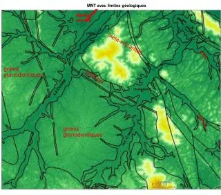
« MNT » canopée à pas de 90 m MNT avec ombrage MNT avec report de la géologie Les principales formations géologiques MNT avec limites géologiques MNT avec limites géologiques


More Related