Download
1 / 30
300 likes | 431 Vues
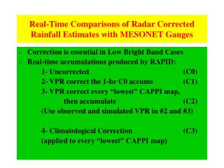
Real-Time Comparisons of Radar Corrected Rainfall Estimates with MESONET Gauges. Correction is essential in Low Bright Band Cases Real-time accumulations produced by RAPID: 1- Uncorrected (C0) 2- VPR correct the 1-hr C0 accums (C1) 3- VPR correct every “lowest” CAPPI map,

E N D
Real-Time Comparisons of Radar Corrected Rainfall Estimates with MESONET Gauges • Correction is essential in Low Bright Band Cases • Real-time accumulations produced by RAPID: 1- Uncorrected (C0) 2- VPR correct the 1-hr C0 accums (C1) 3- VPR correct every “lowest” CAPPI map, then accumulate (C2) (Use observed and simulated VPR in #2 and #3) 4- Climatological Correction (C3) (applied to every “lowest” CAPPI map)
Mesonet Gauge Locations 120 km
UNCORRECTED C1 CORRECTED 1. Accumulations based on CAPPIs at a pre-defined height (1.5 to 2.5 km) (Correction applied to the 1-h accumulations as a function of range) a) dBZ = VPR[ CAPPI height ] - VPR[ Ref. height ](For each of the 5 VPRs) (Ref. Ht: 0.2 to 0.4 km above visibility height, or at BB top if contaminated by low BB) b) Beyond 110 km, apply Gaussian smoother (vertical) to last VPR dBZ = VPRG[H(range)] – VPRLast[ Ref. height ] c) Interpolate dBZ at every km and convert it into a rainfall rate factor d) Multiply uncorrected 1-h accumulations and integrate for total rainfall
2. Accumulations based on OSPmaps (C3) (Optimum Surface Precipitation) (Correction performed at every radar cycle and for every pixel) a) Lowest pixel (~1.3 km) up to 90 km. 2nd elevation angle afterwards - dBZ is obtained from VPR as in (1) to modify reflectivity at selected height b) Automatic VPR identification and correction - Should we avoid rather than correctfor bright band ? (CORRECT) c) No dBZ adjustment for convective pixels ( > 32 dBZ 2 km above BB height) UVIL (above 3.5 km) > 1 or 2 kg/m2 - Separate Z-R for stratiform and convective pixels d) Knowledge of 0º isotherm from model forecasts prevents correction in cases of low bright band. Reflectivity at BB top is used as reference - Identifies low level growth due to warm rain or snow. (Add extra dBZ) - Evaporation: Set to 0 if dBZ < 20, otherwise subtract 5 dBZ
ERRORS DUE TO EXTRAPOLATION FROM HEIGHT OF MEASUREMENT TO GROUND When observed at a farther range 2.0 1.7 0.5 BW=0.2 To determine the errors, values at the measurement height are compared with the low level ground truth
Real-Time Correction (CAPPIs) C2 Corrected Uncorrected OSP The reflectivity at pixels affected by the bright band is reduced while estimates at far ranges (in the snow) are increased.
Real-Time Correction: 1-hr accumulation Convection BB Uncorrected “One-shot” : one map is corrected OSP: 12 CAPPIs are corrected
(a) BB Convection Uncorrected (b) (c) (d) “One-shot” : one map is corrected OSP: 12 CAPPIs are corrected Climatological: 12 CAPPIs are corrected
1-hr Accumulations: 0300 GMT 21-Nov-2004 C1 Unc OSP Clim
0000 Z to 2400 Z 21-Nov-2004 Unc C1 R/G:3.86 %AD:291 Corr:0.77 R/G:1.42 %AD:75 Corr:0.78 OSP Clim R/G:1.19 %AD:48 Corr:0.76 R/G:2.05 %AD:1.18 Corr:0.86
0000 Z to 2400 Z 28-Nov-2004 Unc C1 R/G:1.72 %AD:94 Corr:0.55 R/G:0.94 %AD:38 Corr:0.66 OSP Clim R/G:1.17 %AD:48 Corr:0.74 R/G:1.30 %AD:48 Corr:0.79
2400Z 1-Dec-2004 Unc C1 R/G:1.20 %AD:47 Corr:0.48 R/G:2.06 %AD:119 Corr:0.55 OSP Clim R/G:0.89 %AD:35 Corr:0.47 R/G:1.02 %AD:31 Corr:0.53
0000 Z to 2400 Z 24-Nov-2004 Unc C1 R/G:0.74 %AD:36 Corr:0.71 R/G:0.56 %AD:50 Corr:0.61 OSP Clim R/G:0.68 %AD:38 Corr:0.77 R/G:0.46 %AD:56 Corr:0.80
0000 Z to 2400 Z 16-Oct-2004 Unc C1 R/G:1.19 %AD:32 Corr:0.42 R/G:0.80 %AD:25 Corr:0.52 OSP Clim R/G:0.93 %AD:20 Corr:0.54 R/G:0.73 %AD:30 Corr:0.64
24-hr Accumulation 2200Z 9-Sep-2004 Unc C1 R/G:0.69 %AD:32 Corr:0.73 R/G:0.66 %AD:34 Corr:0.65 OSP Clim R/G:0.66 %AD:34 Corr:0.82 R/G:0.64 %AD:36 Corr:0.81
0000 Z – 2400 Z 1-Jun-2004 R/G:1.28 %AD:33 Corr:0.70 R/G:0.86 %AD:23 Corr:0.64 Climatological correction map not available R/G:0.92 %AD:13 Corr:0.86 R/G:0.97 %AD:13 Corr:0.81
Projection of near range VPRs into far ranges 250 hr of data, 21 events
Total Error Summary: Stratified by BB height(Data from 0.50 elevation for r>100km and from 1.5 km CAPPI for r<100km)
Representativeness of VPR Increased NRMS errors for 1-hr accumulations generated with VPR correction factors that are appropriate for a different time interval (in order to simulate a different VPR at farther ranges). The uncorrected NRMS and that from the climatological correction are provided as reference. (At the “lowest default height” and at 10-km resolution).
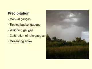
Snowfall Accumulation Unc In snow, it is necessary to correct for the increase in reflectivity of snow as it falls to the surface. The VPR display (Vertical Profile of Reflectivity) helps to quantify this vertical gradient. In general, the VPR is essential for a proper estimate of surface precipitation, particularly under stratiform rainfall conditions.
Real-Time Correction: 24-hr accumulation Uncorrected C1 “One-shot” correction of 24 1-hr acc. maps OSP: 24 x 12 CAPPIs are corrected
FRANKTOWN Radar: 21-hr Accumulation 0900Z 15-Jun-2004 No Climatological Accumulation C1 Unc OSP
0000 Z – 2400 Z 3-Aug-2004 Unc C1 R/G:1.94 %AD:94 Corr:0.89 R/G:1.77 %AD:78 Corr:0.89 OSP Clim R/G:1.69 %AD:74 Corr:0.89 R/G:1.76 %AD:80 Corr:0.88