Metadata Standards in GEOSS Clearinghouse
830 likes | 987 Vues
Metadata Standards in GEOSS Clearinghouse. Kai Liu, Phil Yang, Huayi Wu, Wenwen Li, Zhenlong Li, Tim Miao, Qunying Huang, Center for Intelligent Spatial Computing, George Mason University Douglas Nebert Federal Geographic Data Committee (FGDC). Contents.

Metadata Standards in GEOSS Clearinghouse
E N D
Presentation Transcript
Metadata Standards in GEOSS Clearinghouse Kai Liu, Phil Yang, Huayi Wu, Wenwen Li, Zhenlong Li, Tim Miao, Qunying Huang, Center for Intelligent Spatial Computing, George Mason University Douglas Nebert Federal Geographic Data Committee (FGDC)
Contents 1. Geospatial Metadata and Clearinghouse 2. GEOSS Clearinghouse 3. GEOSS Clearinghouse Administration and Functions 4. Metadata Transformation in Harvesting 5. Metadata Creating 6. Metadata Search
1. Geospatial Metadata and Clearinghouse • Metadata: “Data about Data” • Geospatial metadata: used to describe how geospatial & attribute data was collected & processed into its final form • Allows agencies to: • Organize and maintain an organization's data investment • Share data set information through data catalogs and clearinghouses • Provide access for download or display and analysis through web services • Allows users to: • Discover, • evaluate, and • access geodata resources.
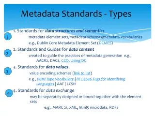
Standards • Allows communication between peers; • Minimizes data integration time … costs • Permits data operations under known conditions • Numerous Geographic Metadata standards exist: • Dublin Core, • FGDC CSDGM, • ISO19115 (UML) • ISO19139 (XML) • OGC WxS Capability Document
Dublin Core • Year 1995: NCSA/OCLC Metadata workshop, Dublin, Ohio • 15 elements in Simple Dublin Core Metadata: all optional, all repeatable, • Title • Subject • Description • Creator • Publisher • Contributor • Date • Type • Format • Identifier • Source • Language • Relation • Coverage • Rights
FGDC CSDGM • CSDGM is the current US Federal Metadata standard. • Standard Organized into 10 sections • Section 1: Identification Information • Section 2: Data Quality Information • Section 3: Spatial Data Organization Information • Section 4: Spatial Reference Information • Section 5: Entity and Attribute Information • Section 6: Distribution Information • Section 7: Metadata Reference Information • Section 8: Citation Information • Section 9: Time Period Information • Section 10: Contact Information
ISO 19115 • International consensus being built on structured metadata within a broader Geomatics Standard under ISO Technical Committee 211 (TC 211) • UML abstract model • ISO 19115 reflects FGDC, TC 287, ANZLIC and other inputs • Specifies content guidance (field vocabulary and structures), like FGDC • ANSI adoption 12/24/2003
Metadata Contact ISO 19115 Organization Data Identification Info Responsible Party Content Information Distribution Info Online Source Spatial Representation Data Quality Info Metadata Reference System Citation Metadata Maintenance Language Character Set Hierarchy Standard Name, Version Date Metadata Constraints Required Application Schema Info Conditional or Optional Portrayal Catalog Info Extension Information
Core ISO Metadata • Title • Reference Date • Responsible Party • Geographic location • Language • Characterset • Topic Category • Scale • Abstract • Format • Extent • Representation Type • Reference System • Lineage • On-line Resource
ISO 19139 • XML Schema implementation of ISO 19115
Metadata Storage and Access Storage: • File system • Database Access: browse, request • CSW • SRU • HtmlParser • GetCapabilities • Local Filesystem
2. GEOSS Clearinghouse • The GEOSS Clearinghouse is a common search facility for the Intergovernmental Group on Earth Observation (GEO) based the GeoNetwork Opensource. • Through the harvesting mechanism, GEOSS clearinghouse collects all types of metadata of EO data, services and other resources • Through distributed search of harvested metadata or registered metadata catalogues, EO data, services, and related resources can be discovered and accessed.
The GEOSS Clearinghouse supports a variety of geospatial standards: • Dublin Core, FGDC CSDGM, ISO 19115/19139 metadata, • CSW, RSS, and SRU for search, • WMS related OGC standards for data access and visualization, as linked from the metadata.
GEOSS Clearinghouse Main Page Supports Multiple languages
Architecture • GEOSS clearinghouse uses Web application with service based architecture (Jeeves) which is a Java Easy Engine for Very Effective Systems. Publishing of the simple systems on the Internet by Jeeves is possible without Java language knowledge and with little effort. • All the interfaces are expressed through XML and XSL files
3. GEOSS Clearinghouse Administration and Functions • Administration • User Management • Search • Harvesting • Metadata Edit and Management • Visualization
4. Metadata Transformation in Harvesting • Harvesting is the process of collecting remote metadata and storing them locally for a faster access. • Currently, about 26 000 metadata were harvested to the GEOSS clearinghouse.
Where GEOSS Harvest From? The GEOSS Clearinghouse is harvesting from the following protocols: • Z39.50 "GeoProfile" (manually-initiated, under testing) • CSW 2.0.2 baseline, AP ISO, ebRIM with no extensions • WebDAV, sitemaps, and Web Accessible Folders (WAF) • OGC GetCapabilities (WMS, WFS, WCS) endpoints • Local file access for batch ingest of packaged, static metadata Also available to the system, are the following protocols: • THREDDS Catalog • OAI-PMH • ISO 23950 "SRU" • GeoNetwork "native"
Metadata of the following three standards can be harvested directly. • Dublin-core • FGDC CSDGM • ISO19115, ISO19139 Other formats must be converted to ISO19139
Metadata Formats Transformation As for formats, the following "Full" metadata formats are recognized and parsed into ISO 19139 metadata for ingest: • ISO 19115, 19119 XML (no transform, per 19139) • ebRIM common information model XML, including the CSR form • FGDC CSDGM Version 2 XML (no transform) • CSW csw:Record XML (no transform) • OGC GetCapabilities XML and other XML
Stylesheets will be used for the Metadata Formats Transformation Stylesheet(*.xsl) Original Metadata ISO Metadata
Stytlesheet example: <?xml version="1.0" encoding="UTF-8"?><xsl:stylesheet version="1.0" xmlns:xsl="http://www.w3.org/1999/XSL/Transform"> <xsl:template match="metadata"> <uuid><xsl:value-of select="mdFileID"/></uuid> </xsl:template></xsl:stylesheet>
Metadata Transformation in CSR Harvesting • CSR: which is short for the GEOSS Component and Service Registry. • ebRIMcomponent2ISO19139.xsl will be used for component’s translating <gmd:fileIdentifier> <gco:CharacterString> <xsl:value-of select="csw:GetRecordByIdResponse/rim:Organization/@*[name()='id']"/> </gco:CharacterString> </gmd:fileIdentifier>
Also, ebRIMservice2ISO19139.xsl will be used for service’s translating <gmd:fileIdentifier> <gco:CharacterString> <xsl:value-of select="csw:GetRecordByIdResponse/rim: Service /@*[name()='id']"/> </gco:CharacterString> </gmd:fileIdentifier>
5. Metadata Creating • In the process of creating metadata, a template can be chosen. Some templates have been developed like below: