Exploring the Volcanic Wonders of Shasta, Lava Beds, and Lassen National Parks
130 likes | 276 Vues
Nestled in the heart of Northern California, the volcanic landscapes of Mount Shasta, Lava Beds, and Lassen National Parks showcase the incredible power of subduction. Mount Shasta rises as a majestic stratovolcano, peaking at 14,162 feet with an immense glacier cover. The area features diverse lava types due to varying magmatic activities, impactful geological processes, and ongoing geothermal phenomena. With stunning volcanic features, rich mineral deposits, and significant glacial formations, these parks offer insight into Earth's dynamic forces.

Exploring the Volcanic Wonders of Shasta, Lava Beds, and Lassen National Parks
E N D
Presentation Transcript
The Cascade Volcanoes • Caused by subduction • Explorer, Juan de Fuca, and Gorda = oceanic plates • North American = continental plate
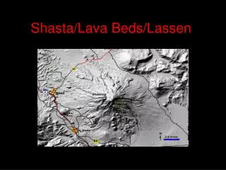
Mt. Shasta • prominent landmark at an elevation of 4,317 meters (14,162 feet) • volume of nearly 500 cubic kilometers makes it the largest of the Cascade stratovolcanoes • Most recent eruption occurred 200 years ago • 7 main glaciers recognized on Shasta today • Seismically and geothermally active
Rocks and Minerals • Rocks Basalt Andesite Dacite • Minerals Olivene Hypersthene Augite Hornblende Biotite Plagioclase Quartz Magnetite
Why are Lavas Diverse? Magma can: a) differentiate; b) bemodified by surrounding rock; and c) mix with other magma to producedifferent types of lavas seen at thesurface. Magma chamber at depth underShasta; basaltic lava rises fromthe mantle below.
Glaciers and Glacial Erosion • 7 main glaciers on Shasta • Total volume of ice isabout 140 million cubic meters • Cirques, aretes, and moraines are all seenon Shasta
Streams and Debris Flows • Multiple debris flows have happened during historic time and will continue to occur • As water runs off of the slopes it maybecome 2 times as dense as water whenvolcanic sediment is incorporated • Slurries develop that are similar to concrete • Streams are able to buoy up and carry rocksmuch larger than normal • http://www.siskiyous.edu/Shasta/map/mp/wdf8-97.mpg
Mass Movement • Downslope falls, slides, or flows of weathered rock due to gravity • 3 factors = steep slopes, weak rocks, and water • Rockfalls common • Debris flows common • Debris Avalanches uncommon, but do occur on Shasta
Lava Beds National Monument • Formed from eruptionsfrom Medicine Lakevolcano • Main rock types = Basalt Aa and Pahoehoe Andesite Rhyolite Tuff Obsidian Pumice
Volcanic Features • Lava Tube Caves • Cinder Cones • Spatter Cones • Craters • Fault Scarps
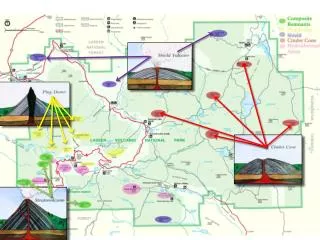
Lassen PeakNational Volcanic Park • Formed from a massiveextrusion of dacite ~11,000 years ago • May have only erupted for a year or two • Mt. Maidu, Mt. Tehama, and Thousand Lakes volcano also formed landscape in greater area • Glaciers have played a major role in shaping the landscape around Lassen • Geothermal activity continues to date
Volcanic & Geothermal Features • Plug domes • Cinder cones • Craters • Debris Avalanches • Lava Flows • Hot springs • Fumaroles • Boiling mud pots
Conclusion • Whole region is formed by subduction • Some lavas are silica rich – pasty, sticky, explosive (Mt. Shasta, Lassen Peak) • Some lavas are silica poor – runny, less explosive/effusive (Medicine Lake/Lava Beds) • Glaciers have played a major role in shaping the landscape • Geologic hazards (mass movements, eruptions) continue to affect the region