Download
1 / 10
100 likes | 201 Vues
World’s largest meromictic basin. Strongly stratified. Deep waters do not mix with the surface. Buoyant fresh water caps the surface. Fresh water from river runoff, and precipitation minus evaporation, which is about 0.6m/yr. Density stratification maintained mainly by salinity.

E N D
World’s largest meromictic basin. • Strongly stratified. Deep waters do not mix with the surface. • Buoyant fresh water caps the surface. Fresh water from river runoff, and precipitation minus evaporation, which is about 0.6m/yr. • Density stratification maintained mainly by salinity. • Salinity of about 18ppt on the surface and 22.5 ppt in the deep.
Because there is no overturning of water, over 90% of the deeper Black Sea volume is anoxic water (bacterial respiration of sinking organic matter uses up all available O2). • Bacteria in the deep sea use sulfate in the oxidation of organic material, which produces hydrogen sulfide, H2S.
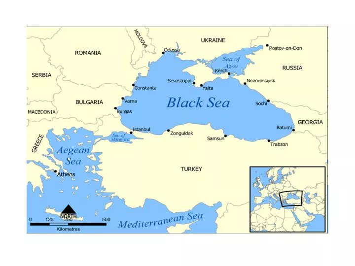
The Bosphorus strait connects the Black Sea with the Sea of Marmara (and the Mediterranean) • Two-way exchange: • Water flowing in from the Mediterranean (about 300km3/yr). • Outflow of about twice this much (fresher water, salinity of about 19psu) out, into the Marmara Sea.
Historic Water Levels • Water levels in the Black Sea were considerably lower during the glacial periods (possibly 100m lower), when it was no longer connected to the Sea of Marmara. • At that time the Black Sea was a land-locked freshwater lake. • Archeologists found fresh-water snail shells and man-made structures in roughly 328 feet (100 m) of water off the Black Sea coast of modern Turkey. • After the last Ice Age water levels in the Aegean, Mediterranean, and Black Sea rose. • Black Sea Deluge Theory.
Temperature • SST varies seasonally from 8-30°C. Deep-sea temp. is about 8.5°C. • Winter cooling can bring SST to about 6°C which forms a cold intermediate layer (CIL), or a layer of minimum temperature, at a depth of about 30-80m. • The CIL is on top of the pycnocline. • So hydrostatically stable stratification is maintained by a stable salinity gradient despite the fact that temp. increases with depth.
Wind-driven circulation • Surface waters circulate in a cyclonic gyre (counter clockwise). • The Rim Current transports water around the perimeter of the Black Sea. • in geostrophic balance. • most intense in winter-spring seasons.
References • Ivanov, L.I. et al., 2001. Convection in the Black Sea during cold winters. Journal of Marine Systems, 31, 1-3. • Knauss, J. 2005. Introduction to Physical Oceanography. Waveland Press, Inc., p.266-268. • Shillington, D. et al., 2008. Cenozoic evolution of the eastern Black Sea. Earth and Planetary Science Letters 265, 360-378.