
Enhanced Understanding of Cold Lands Through MODIS Observations
Explore the impact of global warming on cold land regions like Greenland and Tibetan Plateau using MODIS data. Evaluate surface and atmospheric variations to improve simulations and hydrological processes. Comparisons with NCEP, ECMWF, and NCAR CCSM3 models highlight the need for more accurate simulations over these areas.

Enhanced Understanding of Cold Lands Through MODIS Observations
E N D
Presentation Transcript
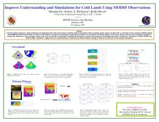
Improve Understanding and Simulations for Cold Lands Using MODIS ObservationsMenglin Jin1, Robert. E. Dickinson2, Keith Oleson31:University of Maryland, College Park; 2: GIT; 3: NCAR----o----MODIS Science team MeetingBaltimore, MD 4-6 January 2005 1mjin@atmos.umd.edu Abstract Cold land regions respond to global warming more significantly than other land surfaces, resulting extreme hydrological events including glacier retreat, ice sheet melt, or reduction in snow coverage. MODIS, together with TRMM and GPCP measurements, provides new information on surface and atmospheric hydrological variations over Greenland and Tibetan Plateau. In this study, diurnal, seasonal, and interannual variations of surface skin temperature, snow coverage, clouds, water vapor and rainfall are examined to illustrate the interaction of surface and atmosphere hydrological processes. Furthermore, evaluations of NCEP, ECMWF and NCAR CCSM3 simulations suggest that more understanding on Greenland and Tibetan Plateau is the key to improve currently far-from-acceptable simulations. Greenland Figure 4: NCAR CCSM3 simulated snow coverage, skin temperature and snow albedo. Comparing with Figs. (1-3), we find that the model overestimated snow lbedo and skin temperature diurnal variation. Figure 1: MODIS observed land cover, albedo, and skin temperature for Greenland. Figure 2: Skin temperature across Greenland Island along 70ºN, for July and May respectively. Meanwhile, corresponding surface albedo for July is also presented. Figure 3: MODIS observed spatial distribution of clouds and water vapor, with corresponding time series to show the interannual and seasonal variations. Tibetan Plateau Summary • Observational MODIS data sets are critical in their description of Greenland and Tibetan Plateau. • NCAR CCSM3 needs improvement in skin temperature, albedo, and atmosphere conditions over cold lands. • MODIS observations are critical in evaluating and improving simulations over the cold land regions. Acknowledgements: This study is funded by NASA Snow and Ice Program (PI-M. Jin) and EOSIDS (PI- R. E. Dickinson). Figure 5: MODIS observed land cover, surface albedo, skin temperature over Tibetan Plateau. The plateau has large cirrus fraction than other regions. Cirrus fraction has evident seasonal variations. Figure 6: Comparison between MODIS skin temperature and NCAR CCSM3 simulated ground temperature shows that the model underestimates skin temperature over the Tibetan Plateau. Figure 7: NCAR CCMS3 simulated annual variations for surface physical processes. Many of such variables need observations to validate, which were unavailable when the simulation experiments was done. MODIS observations can be very useful.


