Cagayan is situated at the northeastern tip of Luzon.
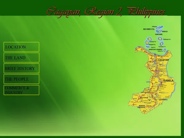
Cagayan is situated at the northeastern tip of Luzon. It is bounded on the north by the Balintang Channel , on the east by the Pacific Ocean, on the west by Ilocos Norte and Kalinga-Apayao, and on the south by Isabela.

Cagayan is situated at the northeastern tip of Luzon.
E N D
Presentation Transcript
Cagayan is situated at the northeastern tip of Luzon. It is bounded on the north by the Balintang Channel, on the east by the Pacific Ocean, on the west by Ilocos Norte and Kalinga-Apayao, and on the south by Isabela.
The province forms the lower basin of the Cagayan River. The eastern coast is hilly and mountainous because of the Sierra Madres. The northern coast is low and marshy, while the western boundary with Kalinga-Apayao is either hilly or low and swampy. Between the low mountains are large valleys. The Babuyan Islands, about 40 to 60 km north of the Luzon mainland, are part of Cagayan. The group is noted for active volcanoes, such as Babuyan Claro and Camiguin Volcano. Didicas Island was once known as Didicas Rock until a submarine volcano erupted in 1952 and formed the island. The general in the Sierra Madres in the east has rainfall that is more or less evenly distributed throughout the year. The rest of the provinces is relatively dry from November to April and wet the rest of the year.
The province could have gotten its name from the Ilocano word carayan or "big river," referring to the Rio Grande De Cagayan, the longest river in the country, which bisects its valley from north to south. Or it could have been derived from the tagay trees (tall hardwood) that grew along the river banks. It is possible that the area was called Catagayan, meaning "where the tagay abounds." The earliest inhabitants were the Aetas, short dark-skinned nomads belonging to the Negrito family. They were followed by Indo-Malay immigrants who came to be known as Ibanags. Before the Spaniards banks and were trading with the Chinese and other merchants from neighboring countries. In 1572, Juan de Salcedo explored Cagayan Valley. By 1583, all the territories east of the Cordillera Central Mountains and north of the Caraballo Mountain Range formed one political unit called "La Provincia de Cagayan." Its capital was Nueva Segovia (now the town of Lal-lo, near Aparri).
Ilocano migrants now outnumber the native groups, the majority of which are the Ibanags and Gaddangs. Smaller groups include the Isneg, the Malaueg, and the Itawes who live along the western boundaries. The Negrito population is variously known as Aetas, Agtas, Pugots, and Dumagatas.
The province's agricultural production is concentrated on two areas. The Cagayan Rover Delta produces rice, corn, vegetables, and rootcrops. The region near the boundary with Isabela contains a number of large tobacco plantations. The mountain ranges yield good hardwoods, as well as rattan and other forest products used in cottage industries. Fishing is a major industry in the coastal areas.
Batanes The Province of Batanesalso called the Batanes Islands, is a Philippine province comprising ten islands that are located in the Luzon Strait between the islands of Luzon and Taiwan. It is the northernmost part of the Philippines and is also the smallestprovince, both in terms of population and land area.The island group is located about 162 km north of Luzon and about 190 kilometers south of Taiwan, separated from the Babuyan Islands of Cagayan Province, Luzon, by the Balintang Channel and from Taiwan by the Bashi Channel. The provincial capital is Basco on Batan Island and the only other inhabited islands are Itbayat and Sabtang. The northernmost island of the province, making it the northernmost island in the Philippines, is Mavudis (Yami) Island. Other islands in the chain are Misanga,Siayan, Ivuhos, and Dequey. The province is officially in the region of Cagayan Valley. The islands are part of the Luzon Volcanic Arc. History People and Culture Municipalities
Batanes The ancestors of today's Ivatans are descended from Austronesians who migrated to the Batanes Islands 4000 years ago during the Neolithic period. They lived in fortified mountain areas called idjangs and drank sugar-cane wine, or palek. They also used gold as currency and produced a thriving agriculture-based industry. They were also seafarers and boat-builders. In 1687, a crew of English freebooters headed by William Dampier came with a Dutch crew and named the islands in honor of their country's monarchs. Itbayat was named "Orange Isle" in honor of William of Orange, and Batan was named "Grafton Isle" after Henry FitzRoy, 1st Duke of Grafton. Sabtang Isle was named "Monmouth Isle" after the James Scott, 1st Duke of Monmouth. Capt. Dampier stayed for less than three months, and did not claim the islands for the British crown. Toward the end of the Spanish regime, Batanes was made a part of Cagayan. In 1909, however, the American authorities organized it into an Independent province. Because of its strategic location, the Batanes island group was one of the first points occupied by the invading Japanese imperial forces at the outbreak of the Pacific War. During the American colonial period, public schools suddenly boomed, and more Ivatan became more aware of their place in the Philippines. One of the first School Superintendents was Victor De Padua, an Ilocano, who in 1942-45 during the Japanese occupation was made Provincial Governor. History People and Culture Municipalities
Batanes History The people of Batanes are called Ivatan and share prehistoric cultural and linguistic commonalities with the Babuyan on Babuyan Island and the Tao people ofOrchid Island. This divided homeland is a result of the Dutch invasion of Taiwan in 1624 ( Dutch Formosa ) and Spanish invasion in 1626 ( Spanish Formosa ). The northern half of the Ivatan homeland, Formosa and Orchid Island which were formally part of the Viceroyalty of New Spain, fell to the Dutch who were in turn expelled in 1662 by forces of the Chinese Ming Dynasty, led by the Chinese pirate Koxinga who then set himself up as The King of Taiwan. The southern half of the Ivatan homeland, the islands of the Batanes, was reinforced and fortified by Spanish refugees from Formosa before being formally joined in the 18th century with the Spanish government in Manila. The main languages spoken in Batanes are Ivatan, which is spoken on the islands of Batan and Sabtang, and It bayaten, which is spoken primarily on the island of Itbayat. The Ivatan which is dominant in the province is considered to be one of the Austronesian languages. From college level down to elementary level, the language is widely spoken People and Culture Municipalities
Batanes History Batanes is subdivided into 6 municipalities. Batanes has only one congressional district. Municipalities BascoMahatao ItbayatIvana SabtangUyugan People and Culture Municipalities
Cagayan History Cagayan (pronunciation: the "Land of Smiling Beauty", is a province of the Philippines in the Cagayan Valleyregion in Luzon. Its capital is TuguegaraoCity and is located at the northeastern corner of the island of Luzon. Cagayan also includes the Babuyan Islands to the north. The province borders Ilocos Norte and Apayao to the west, and Kalinga and Isabela to the south. Cagayan province is distinct from the city in Mindanao named Cagayan de Oro, and is far away from Cagayancilloof Palawan or Cagayan de Tawi-Tawi Island in the Sulu Sea. Present day chroniclers say that the name was derived from the word “tagay,” a kind of plant that grows abundantly in the northern part of the province. Thus, “Catagayan” which means a place where the tagay grows abundantly was shortened to “Cagayan,” the present name of the province. Cagayan, the "Land of Smiling Beauty", is a province of the Philippines in the Cagayan Valleyregion in Luzon. Its capital is Tuguegarao City and is located at the northeastern corner of the island of Luzon. Cagayan also includes the Babuyan Islands to the north. The province borders Ilocos Norte and Apayao to the west, and Kalinga and Isabela to the south. Cagayan province is distinct from the city in Mindanao named Cagayan de Oro, and is far away from Cagayancilloof Palawan or Cagayan de Tawi-Tawi Island in the Sulu Sea. Present day chroniclers say that the name was derived from the word “tagay,” a kind of plant that grows abundantly in the northern part of the province. Thus, “Catagayan” which means a place where the tagay grows abundantly was shortened to “Cagayan,” the present name of the province. Geography Municipalities
Cagayan History In 1581, Captain Juan Pablo Carreon came to Cagayan with one hundred fully equipped soldiers with their families by order ofGonzaloRonquillo de Peñaloza, the fourth Spanish Governor-General of the Philippines, to explore the Cagayan Valley and to force the conversion of the natives to Catholicism as well as to establish ecclesiastical missions and towns throughout the valley. This was the first batch of Spanish settlers in the Cagayan Valley who introduced Spanish culture and Latin civilization, subverting native culture, customs, and tradition. On June 29, 1583, Juan de Salcedo traced the northern coastline of Luzon and set foot on the Massi (Pamplona), Tular, and Aparri areas. The Spanish friars soon established mission posts in Camalaniugan and Lal-lo(Nueva Segovia), which became the seat of the Diocese established by Pope Clement VIII on August 14, 1595. The Spanish influence can still be seen in the massive churches and other buildings that the Spaniards built for the spiritual and social welfare of the people. With the Treaty of Paris was signed in 1898, ending the Spanish-American War, America took over the Philippines and influenced the culture, most notably in agriculture and education as well as in public works and communications. At the close of the 18th century, there were 29 municipalities in the province of Cagayan. When the Philippines came under American sovereignty in 1902, 35 municipalities have been founded. Since then, however, on account of the tendency at centralization and shifting of population as a result of the opening of roads and public agricultural lands, only 29 municipalities now remain. Geography Municipalities
Cagayan History The province is bounded by the Pacific Ocean on the east; on the south by Isabela province; on the west by the Cordillera Mountains; and on the north by the Balintang Channel and theBabuyan Group of Islands. About two kilometers from the northeastern tip of the province is the island of Palaui; a few kilometers to the west is Fuga Island. The Babuyan Group of Islands, which includes Calayan, Dalupiri, Camiguin, and Babuyan Claro, is about 60 nautical miles (110 km) north of Luzonmainland. The province comprises an aggregate land area of 9,002.70 square kilometers, which constitutes three percent of the total land area of the country, making it the second largest province in the region. Cagayan has 28 municipalities and one city divided into three congressional districts. It has 820 barangays. TuguegaraoCity (as of December 18, 1999) is the provincial capital, regional seat, and center of business, trade, and education. It has a land area of 144.80 square kilometers and a population of 120,645 as of 2000. Geography Municipalities
Cagayan City Tuguegarao City Municipalities Abulug Alcala Allacapan Amulung Aparri Baggao Ballesteros Buguey Calayan Camalaniugan Claveria Enrile Gattaran Gonzaga History Geography Iguig Lal-Lo Lasam Pamplona Peñablanca Piat Rizal Sanchez-Mira Santa Ana Santa Praxedes Santa Teresita Santo Niño (Faire) Solana Tuao Municipalities
Isabela Isabela is the second largest province of the Philippines next to Palawan. It is located in the Cagayan lleyRegion in Luzon. Its capital is Ilagan and borders, clockwise from the South, Aurora, Quirino, Nueva Vizcaya, Ifugao, Mountain Province, Kalinga, andCagayan. This primarily agricultural provinceis the rice and corn granary of Luzon due to its plain and rolling terrain. History People and Culture Municipalities Major Industries
Isabela Prior to 1856, there were only two provinces in the Cagayan Valley Region Cagayan and Nueva Vizcaya. The Province of Cagayan at that time consisted of all towns from Tumauini to the north in Aparri and all other towns from Ilagan, Roxas southward to Aritaocomprised the Province of old Nueva Vizcaya. In order to facilitate the work of the Catholic missionaries in the evangelizationIn the Cagayan Valley, a royal decree was issued on May 1, 1856 that created the Province of Isabela consisting of the towns of Gamu,OldAngadanan (now Alicia), Bindang(now Roxas) and Camarag (now Echague), Carig(now Santiago City) and Palanan, all detached from Nueva Vizcaya; while Cabagan and Tumauini were taken from the Cagayan province. The province was put under the jurisdiction of a governor with the capital seat at Ilagan, where it remains at the present. It was initially calledIsabela de Luzon to differentiate from other places in the Philippines bearing the name of Isabela. The new province was named in honor of Queen Isabela II of Spain. Although the province did not play a major role in the revolt against Spain, it was in Palanan that the final pages of the Philippine Revolution were written when the American forces led by General Frederick Funston finally capturedGeneral Emilio Aguinaldoon March 23, 1901. History People and Culture Municipalities Major Industries
Isabela According to the latest Philippine Census, Isabela is the most populated province among the five provinces in Cagayan Valley (Region II). It has a population of 1,401,495 people and comprising 45.93 percent of the 3 million people in the region. At the national level, the province contributed 1.58 percent to the total population of 88.57 million. There are 254,928 households in the province. For all ages, the sex ratio in Isabela was about 105 with 660,627 males and 626,948 females in the 2000 Census of Population and Housing (Census 2000). There are more males than females below 50 years old. Ilocanos are the most prominent group in Isabela. Of the total household population, 68.71 percent classified Themselves as Ilocanos. The next two prominent groups(ethnic) are Ibanag(14.05 percent) and Tagalog (10.02 percent). The remaining 7.22 percent are either Gaddang, Paranan, Yogad, or are from other ethnic groups. History People and Culture Municipalities Major Industries
Isabela History Cities Cauayan City Santiago City Municipalities Alicia Angadanan Aurorast Benito Soliven Burgos Cabagan Cabatuan Cordon DelfinAlbano (Magsaysay) Dinapigue Divilican People and Culture Echague Gamu Iligan Jones Luna Maconacon Malilig Naguilan Palanan Quezon Quirino Ramon Reina Marcedes Roxas San Agustin San Guiliermo San Isidro San Manuel San Mariano San Mateo San Pablo Santa Maria Santo Tomas Tumauni Municipalities Major Industries
Isabela Agriculture is the major industry of the people of Isabela. Farming is highly mechanized as most of the agricultural lands are irrigated. With the presence of the Isabela State University, joint ventures and other foreign assisted projects and the Magat Dam contribute to the high productivity in agriculture. It is also the hub of trade and commerce and other economic activities due to its central location in the region. The wood industry used to be a top earner for the province but due to the logging ban imposed in the Cagayan Valley Region, activities in this industry considerably declined. However, furniture making using narra and other indigenous forest materials continue to exist. Potential investments are in fisheries and tourism. Isabela has a fertile fishing ground on the Pacific Coast. The reservoir of the Magat Dam is utilized for fish cage operations for tilapia Production for domestic markets. Tourism is relatively a new industry being developed in the province. Support services and accommodation facilities are likewise being developed. History People and Culture Municipalities MajorIndustries
Quirino History Quirino is a land-locked province in the Philippines located in the Cagayan Valleyregion in Luzon. Its capital is Cabarroguis and was named after Elpidio Quirino, the sixth President of the Philippines. The province bordersAurora to the southeast, Nueva Vizcaya to the west, and Isabela to the north. Quirino used to be part of the province of Nueva Vizcaya, until it was separated in 1966. Economy Municipalities
Quirino Long before its formal creation as an independent province, Quirino was the forest region of the province of Nueva Vizcaya, inhabited by tribal groups known as the Negritos. They roamed the hinterlands and built their huts at the heart of the jungle. Quirino lies in the southeastern portion of Cagayan Valley. It is situated within the upper portion of the Cagayan River basin and bounded by Isabela on the north, Aurora on the east and southeast, and Nueva Vizcaya on the west and southwest.TheIlocano dialect is used widely in the lowlands of the province’s various municipalities while Ifugao is predominant in the uplands. Quirino province acquired its juridical personality as a result of the division of the provinces of Nueva Vizcaya and Isabela on June 18, 1966 under RA 4734. Quirino, named after the late president Elpidio Quirino, was created as a sub-province ofNueva Vizcaya in 1966. It became a full province in 1971. History Economy Municipalities
Quirino History Agriculture is the main industry in Cagayan Valley, together with rice and corn as major crops. These supply the demand of neighboring provinces and the metropolis. Banana as well as banana chips are major products sold in Metro Manila and Pampanga. Small scale industries Like furniture making, basketry, rattan craft, and dried flower production are prevalent. Economy Municipalities
Quirino History Quirino is subdivided into 6 municipalities. Aglipay Cabarroguis(capital) Diffun Maddela Nagtipunan Saguday Economy Municipalities
Nueva Vizcaya History Nueva Vizcaya (Filipino: BagongBiskaya) is a province of the Philippineslocated in the Cagayan Valleyregion in Luzon. Its capital is Bayombong. It is bordered by, clockwise from the north, Ifugao, Isabela, Quirino, Aurora, Nueva Ecija, Pangasinan, and Benguet. Tourist Spots Municipalities
Nueva Vizcaya The name was derived from the Spanish province Vizcaya in the Basque Country. The province of Nueva Vizcaya used to be a territory of the vast Cagayan Valley which was once an integral political unit with one governor. In 1839, then-Governor Luis Lardizabal issued an order transforming Nueva Vizcaya into a politico-military province upon the advice of the alcalde mayor ofCagayan. The order was approved by a Royal Decree on April 10, 1841. The province had its first taste of civil governance in 1902 when it was organized by the Philippine Commission. The present territory of Nueva Vizcaya was the result of changes emanating from the formal creation of the province of Isabela in May 1865, wherein a great portion of its northern territory was ceded to the newly-born province. In 1908, the organization of the province of Ifugao further reduced the area of Nueva Vizcaya which was forced to give up its northwest territory. The survey executed by the Bureau of Lands in 1914 further caused the diminution of its area and reduced again upon the enactment of the Administrative Code of 1917. History Industry Municipalities
Nueva Vizcaya History On January 11, 2008, the Cagayan Bureau of Fisheries and Aquatic Resources (BFAR) stated that tilapia (species of cichlid fishes from the tilapiine cichlid tribe) production grew and Cagayan Valley is now the Philippines’ tilapia capital (Saint Peter’s fish). Production supply grew 37.25% since 2003, with 14,000 metric tons (MT) in 2007. The recent aquaculture congress found that the growth of tilapia production was due to government interventions: provision of fast- growing species, accreditation of private hatcheries to ensure supply of quality fingerlings, establishment of demonstration farms, providing free fingerlings to newly constructed fishponds, and the dissemination of tilapia to Nueva Vizcaya (in Diadi town). Former cycling champion Lupo Alava is a multi-awarded tilapia raiser in Bagabag, Nueva Vizcaya. Chairman Thompson Lantion of the Land Transportation Franchising and Regulatory Board, a retired two-star police general, has fishponds in La Torre, Bayombong, Nueva Vizcaya. Also, Nueva Vizcaya Gov. Luisa Lloren Cuaresma also entered into similar aquaculture endeavors in Addition to tilapia production. Industry Municipalities
Nueva Vizcaya Nueva Vizcaya is subdivided into 15 municipalities. Alfonso Castañeda Ambaguio Aritao Bagabag Bambang Bayombong Diadi Dupax del Norte Dupax del Sur Kasibu Kayapa Quezon Santa Fe Solano Villaverde History Industry Municipalities