Predicting Extratropical Transition Outcomes: A Statistical Technique for Tropical Cyclones
130 likes | 257 Vues
This study presents a novel technique for anticipating the behavior of tropical cyclones (TCs) during their extratropical transition (ET). By utilizing statistical pattern-recognition methods on 70 ET storms from 1997 to 2003, the approach aims to distinguish TCs that will intensify from those that will dissipate. The methodology integrates eigenanalysis to derive key principal components, enhancing forecast reliability. The findings suggest that incorporating multiple variables can significantly enhance prediction accuracy and inform more nuanced operational decisions in meteorology.

Predicting Extratropical Transition Outcomes: A Statistical Technique for Tropical Cyclones
E N D
Presentation Transcript
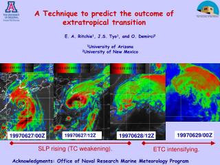
19970629/00Z 19970627/00Z 19970627/12Z 19970628/12Z SLP rising (TC weakening). ETC intensifying. A Technique to predict the outcome of extratropical transition E. A. Ritchie1, J.S. Tyo1, and O. Demirci2 1University of Arizona 2University of New Mexico Acknowledgments: Office of Naval Research Marine Meteorology Program
Objective – develop a simple technique that adds value to the NWP forecasts during ET Method:- ET is a very “visual” problem - use statistical pattern-recognition techniques Initial attempt:- objectively distinguish ahead of time those TCs that will intensify from those that will dissipate during ET.
36 h into S2 During S1 End of S1 Peter 1997 (+) Ivan 1997 (-) ET + 00
- Data - NOGAPS analyses interpolated to a 61o long. x 51o lat. grid of 1o resolution centered on the TC location - TC location from JTWC best track data or from minimum sea-level pressure determined from NOGAPS analyses. • - Training Data - 70 ET Storms from 1997 – 2003 western N-Pacific • - Test Data – 27 ET Storms from 2004 - 2005
Training set - 70 cases of ET of 3000–D data at 9 different times from 1997 – 2003 1. Run eigenanalysis at each time 70 EOFs and PCs each TC has a unique set of PCs represent TCs by their PCs 51 pts 61 pts 2. The higher-order EOFs contain “noise” not relevant to our problem -> results in over-fitting of the data a) retain largest 20 PCs (~98% of variance) b) optimize over highest 20 PCs to get “most important” 10 PCs of these 20. -> removes high-order information (over-fitting) -> improves the robustness of the system.
û0 PC1 PC2 û0 PC1 PC2 3. Find a unit vector, û0, that maximises the separation (d’) of the two populations in 10-PC space. û0= ai + bj + ck + dl + …
Now we can plot the probability distribution of the training data against the projection distance to û0 And the corresponding Receiver Operating Characteristic (ROC) curve PF = 1 - TN . (TN+FP) PD = TP . (TP+FN)
û0 PC1 PC2 End Images What is the technique actually “seeing” to do its prediction?
Dissipating Cases Intensifying Cases Height 700 mb Wind 200 mb Potential Temp 850 mb
Multivariable – incorporate two variables at a single into the training set using EEOF, SVD analysis or a technique we call “3D-space” to replace the EOF analysis step
Results for Temperature and Divergence using EEOF Divergence
Results for Temperature and Divergence using SVD Divergence
Conclusions and Future Work System is “simple” – provides a yes or no decision – adds confidence to a NWP forecast. • Incorporating multiple variables generally improves performance (measured by increased detection for same false-alarm rate). • Increase the Training Set substantially • - improve utility by increasing the number of classes discriminated:- Strong, Moderate, Weak intensifiers, dissipators • Fast, Moderate, Slow intensifiers • Early, Delayed intensifiers • - better representation of any individual storm • - better representation of seasonal and interannual cycles in the training set • (Reanalysis data or use model to “create” training set • Move away from model dependence by using remote-sensed data that discriminate the two classes • – e.g., surface winds, precipitation estimates.
