Download
1 / 19
190 likes | 309 Vues
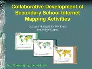
Collaborative Development of Secondary School Internet Mapping Activities. Dr. David M. Diggs, Dr. Phil Klein, and Anthony Lopez. http://geography.unco.edu/sbc. Project Goals:.

E N D
Collaborative Development of Secondary School Internet Mapping Activities Dr. David M. Diggs, Dr. Phil Klein, and Anthony Lopez http://geography.unco.edu/sbc
Project Goals: • Create a series of short internet-based exercises that look at spatial relationships among world biomes, major climate regimes, major soil groups (according the United Nation’s Food and Agriculture Organization—FAO), and relative fertility of those soil groups • This presentation describes 1) development of the project; 2) the collaborative process; and 3) some of the project’s products and problems.
Project History: • Univ. of Northern CO has a long history of service to K-12 Geography Education Community. • Undergraduate student with interest in soil fertility and biomes (developed during Resource Management class). • Student (a GIS emphasis major) took upper-level course for future K-12 Geography teachers. • Student decided to do class project on creating an ArcIMS site for teaching about biomes and soil fertility. • Evolved into project that became available on the web.
Undergraduate Student • Produced ArcIMS service and website. • Data manipulation on biomes and soil fertility. • Conceptual document on how the website could be used to teach about biomes and soil fertility. First draft ArcIMS website (ultimately—not used)
Geog. Ed. Professor • Used a poorly done map of world soil fertility for many years (bad projection), redrawn by hand on Robinson projection. • Associated this with climate maps. • Lack of learning materials (geography) focused on soil fertility, biomes, climate, and soils. • Needed “Guided Inquiry” process, with scaffolding of activities to guide secondary students.
GIS Professor • Aided student during his ArcIMS development phase. • Database problems—USDA Soil Taxonomy System. Need to use World Reference Base (WRB) Soils (1974, 1988, 1998). • Soil Fertility (Van Velthuizen 2007) important. Van Velthuizen, Harrij, et al. 2007. Mapping Biophysical factors that influence Agricultural Production and Rural Vulnerability. Environment and Natural Resources Series 11. United Nations, FAO and the International Institute of Applied Systems Analysis. Available at: http://www.fao.org/docrep/010/a1075e/a1075e00.htm Last accessed: 4/16/2009.
What now? • Let’s do something with this! • See if there is interest (Geog. Ed. Prof. contact teachers). • Small amount of funding. • Need to keep it simple—think audience. • Develop some draft ArcIMS websites/services and associated learning activities (GIS professor).
Database needs and problems: • The easystuff: collapse WWF biomes to generalized biomes; basic climate map; and reference layers. • Soil database. Fertility descriptions use 1988 WRB. We thought it best to use 1998 WRB. • Soil Fertility based on verbal rating of soil suitability for agriculture (Van Velthuizen 2007). Initially we converted it to a 10 point ordinal scale. • What about alignment?
Pre- and Post Design: Activity One
Activity Two Activity Three
Simple portal website: http://geography.unco.edu/sbc
Learning Activities • 3 ArcIMS websites, 3 activities. • Activities lead to the discovery of important geographic concepts (via Guided Inquiry). • Extensive scaffolding of the activities is necessary to guide secondary student to these discoveries.
Testing • Final revision of the materials involved classroom testing of the activities and website. • A recently retired teacher, with many years of experience teaching in middle-school, was hired to develop the activity ideas into a format usable in the secondary classroom. • Tested in 9th grade geography course in Denver-Boulder suburbs.
Testing • “the best, most friendly GIS lesson” she had ever used, commenting that it meets both geography and earth science standards, making it useful both in middle-school social studies and science curricula. • Linked to literacy standards. • Students liked the exercises. • HOWEVER, early in the testing phase it was clear that we needed ancillary materials.
WRB 1998 Soil Groups Major Biomes Major Climates
Conclusions • Active involvement of all participants resulted in dramatically improved websites and learning activities. • Cartographic and technical decision-making was often a process of compromise due to software and database limitations. • Funding and time constraints do not necessarily doom an idea! • Despite these constraints it is still possible to create learning materials that are pedagogically strong, have relatively appealing cartographic design, and are deemed valuable by secondary teachers and students. http://geography.unco.edu/sbc
Author Information Dr. David M. Diggs and Dr. Phil KleinGeography ProgramSchool of Social SciencesCollege of Humanities and Social SciencesCampus Box 115University of Northern ColoradoGreeley, CO 80639 david.diggs@unco.edu phil.klein@unco.edu Anthony LopezGIS ScientistNational Renewable Energy Laboratory1617 Cole Blvd.Golden, Colorado 80401 Acknowledgements Partial funding for this project came from the Colorado Geographic Alliance. Thanks to Paula Sinn-Penfold for extensive help in developing and testing the worksheet activities. Also a thank you goes out to Scott Allen, Monarch High School, Louisville, Colorado http://geography.unco.edu/sbc