Arctic SDI: Integrated Spatial Data Infrastructure
50 likes | 156 Vues
A collaboration between Arctic Council and national mapping authorities to provide access to thematic data, digital maps, and tools for decision-making in the Arctic region.

Arctic SDI: Integrated Spatial Data Infrastructure
E N D
Presentation Transcript
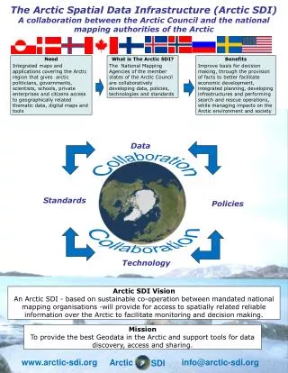
The Arctic Spatial Data Infrastructure (Arctic SDI) A collaboration between the Arctic Council and the national mapping authorities of the Arctic Need Integrated maps and applications covering the Arctic region that gives arctic politicians, governments, scientists, schools, private enterprises and citizens access to geographically related thematic data, digital maps and tools What is The Arctic SDI? The National Mapping Agencies of the member states of the Arctic Council are collaboratively developing data, policies, technologies and standards Benefits Improve basis for decision making, through the provision of facts to better facilitate economic development, integrated planning, developing infrastructures and performing search and rescue operations, while managing impacts on the Arctic environment and society Data Collaboration Standards Policies Collaboration Technology Arctic SDI Vision An Arctic SDI - based on sustainable co-operation between mandated national mapping organisations -will provide for access to spatially related reliable information over the Arctic to facilitate monitoring and decision making. Mission To provide the best Geodata in the Arctic and support tools for data discovery, access and sharing. www.arctic-sdi.org info@arctic-sdi.org Arctic SDI
The Arctic Spatial Data Infrastructure (Arctic SDI) A collaboration between the Arctic Council and the national mapping authorities of the Arctic Data flow in the Arctic SDI from Collection to Action www.arctic-sdi.org info@arctic-sdi.org Arctic SDI
The Arctic Spatial Data Infrastructure (Arctic SDI) A collaboration between the Arctic Council and the national mapping authorities of the Arctic The Arctic SDI Technical Architecture. The Arctic SDI must be seen in the context of domestic realities and complement the UN-GGIM, INSPIRE, ELF, NSDI and CGDI activities. www.arctic-sdi.org info@arctic-sdi.org Arctic SDI
The Arctic Spatial Data Infrastructure (Arctic SDI) A collaboration between the Arctic Council and the national mapping authorities of the Arctic The Arctic SDI Reference Model with the purpose to aid strategic Arctic SDI discussions by grouping existing and potential SDI components. All Arctic SDI activities link to the Reference Model. The Arctic SDI corporation is based upon a Memorandum of Understanding and the organizational structure is based on activities that are being carried out by the participating National Mapping Agencies on a voluntary basis www.arctic-sdi.org info@arctic-sdi.org Arctic SDI