TOLNet
T ropospheric O zone L idar Net work ( TOLNet ) - Long-term Tropospheric Ozone and Aerosol Profiling for Satellite Continuity and Process Studies.

TOLNet
E N D
Presentation Transcript
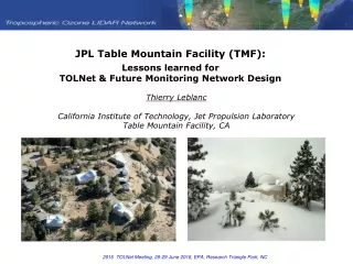
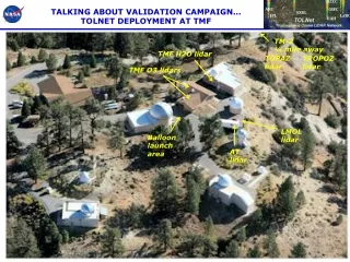
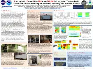
Tropospheric Ozone LidarNetwork (TOLNet) - Long-term Tropospheric Ozone and Aerosol Profiling for Satellite Continuity and Process Studies Mike Newchurch1, Jassim A. Al-Saadi3,5, Raul J. Alvarez2, John Burris4, Wesley Cantrell1, Gao Chen5, Russell DeYoung5, R. Michael Hardesty2, Raymond M. Hoff9, Jack A. Kaye3, Shi Kuang1, Andy Langford2, Thierry Leblanc6, Stuart McDermid6, Thomas J. McGee4, R. Bradley Pierce7, ChristophJ. Senff2, John Sullivan9, Jim Szykman8, Gail Tonnesen8, Lihua Wang1 1UAHuntsville, 2NOAA/ESRL, 3NASA/HQ, 4NASA/GSFC, 5NASA/LaRC, 6NASA/JPL, 7NOAA/NESDIS, 8USEPA, 9UMBC Introduction An interagency research initiative for ground-based ozone and aerosol lidar profiling recently funded by NASA has important applications to air-quality studies in addition to the goal of serving the GEO-CAPE and other air-quality missions. Ozone is a key trace-gas species, a greenhouse gas, and an important pollutant in the troposphere. High spatial and temporal variability of ozone affected by various physical and photochemical processes motivates the high spatio-temporal lidar profiling of tropospheric ozone for improving the simulation and forecasting capability of the photochemical/air-quality models, especially in the boundary layer where the resolution and precision of satellite retrievals are fundamentally limited. It is well known that there are large discrepancies between the surface and upper-air ozone due to titration, surface deposition, diurnal processes, free-tropospheric transport, and other processes. Near-ground ozone profiling has been technically challenging for lidars due to some engineering difficulties, such as near-range saturation, field-of-view overlap, and signal processing issues. This initiative provides an opportunity for us to solve those engineering issues and redesign the lidars aimed at long-term, routine ozone/aerosol observations from the near surface to the top of the troposphere at multiple stations (i.e., NASA/GSFC, NASA/LaRC, NASA/JPL, NOAA/ESRL, UAHuntsville) for addressing the needs of NASA, NOAA, EPA and State/local AQ agencies. The objectives of this initiative are to (1) provide high-resolution time-height measurements of ozone and aerosols at a few sites from near surface to upper troposphere for air-quality/photochemical model and satellite retrieval validation; (2) Exploit synergies with EV-I/TEMPO, DISCOVER-AQ, GEO-CAPE, and existing networks, including regulatory surface monitors and thermodynamic profilers, to advance understanding of processes controlling regional air quality and chemistry; (3) develop recommendations for lowering the cost and improving the robustness of such systems to better enable their possible use in future national networks to address the needs of NASA, NOAA, EPA and State/local AQ agencies. 3. Measurements 2. Instrumentation Figure 1. Truck-based, scanning NOAA/ESRL TOPAZ lidar at the 2012 Uintah Basin study. TOPAZ (Tunable Optical Profiler for Aerosol and oZone) lidar is a state-of-the-art, compact differential absorption lidar (DIAL) for measuring ozone profiles with high temporal and spatial resolution [Alvarez et al., 2011]. The instrument is based on a Nd:YLF pumped Ce:LiCAF ultraviolet laser. TOPAZ emits three Figure 5. The TOPAZ lidar was deployed in the Feb. 2012 Uintah Basin study to investigate high wintertime ozone levels observed in the oil and gas fields of northeast Utah. Because very shallow boundary layers created by stable conditions are thought to be a contributing factor to the high ozone, lidar observations were made using elevation angle sequences of 2, 10, and 90 degrees (Left panel), that were repeated approximately every five minutes. The ozone profiles measured at these three angles are spliced together to create composite vertical profiles extending from 15 m to about 3 km AGL. The effective vertical resolution of the composite ozone profiles increases with altitude from 3 to 90 m. The ozone time-height cross section (right panel) shows a descending elevated ozone layer that appears to get mixed down to the surface in the late afternoon. TOLNet wavelengths, that can be turned from approximately 283 nm to 310 nm. Ozone profiles are typically retrieved at a range resolution of 90 m. Time resolution varies from 10 s to several minutes depending on the atmospheric conditions and the desired precision of the data. Originally designed for airborne operation, the TOPAZ lidar was installed in a truck in January 2012 to permit easy transport to and operation at remote sites. A two-axis scanner mounted on the roof of the truck permits pointing the laser beam at several shallow elevation angles at a fixed, but changeable azimuth angle. Zenith operation is achieved by moving the scanner mirror out of the laser beam path. By using the scanner to vary the elevation angle, high resolution ozone measurements can be obtained to within 15 m of the surface. Horizontal measurements at different azimuth angles can be performed to study the variability of ozone near the surface. Figure 7. An ozone enhancement in the nocturnal residual layer [Kuang et al., 2011 AE]was observed by the UAH ozone lidar from the late evening to midnight on 4 October 2008 (upper). The positively correlated aerosol structure measured by a co-located ceilometer (lower) suggests a low-level transport responsible for the elevated boundary layer ozone. Positive correlation of ozone and aerosol due to transport Figure 6.Simultaneous ozone (left) and water vapor (right) mixing ratio deviations from a multi-day mean showing the evolution, with 10-minute resolution, of a stratospheric intrusion and the anti-correlation of ozone and water vapor. Figure 8. Comparisons of ozone DIAL observations and RAQMS model simulations (1°x1° horizontal resolution, by B. Pierce/NOAA/NESDIS) for Huntsville, May 1- 7, 2010. RAQMS captures some of the FT ozone layers due to large scale transport, such as 7-km high-ozone layer on May 3 and 4-km low-ozone layer on May 5, and the ozone enhancement in the PBL from May 4 to May 6. The model misses some of the ozone filaments such as the two thin layers on May 7. May 3 May 4 May 5 Daytime PBL top collapsed Figure 2. The UAHuntsville O3 lidar system was developed jointly by UAHuntsville and NASA/GSFC [Kuang et al., 2011 IEEE]. (Left) Recently added 1’’ mini receiver to measure ozone between 100 and 1000m altitude; (Right) Raman shifted YAG transmitter replacing previous dye lasers. Located at a 200-m ASL slightly polluted city, this lidar makes ozone retrieval from 0.1 to ~12 km during both daytime and nighttime with a typical integration time from 2 to 10 min. Range resolution varies from ~100m in the PBL to ~750m at upper-troposphere. This system operates with three telescopes, 1’’, 4’’ and 16’’. The current two-wavelength (285 and 291nm) transmitter system will be replaced by a three-wavelength (284, 289, and 299nm) transmitter. EPA surface May 1 May 2 May 3 May 4 May 5 May 6 May 7 May 8 May 6 Captured Missed 89ppbv, highest in 2010 18’’ detector May 7 Raman cells 5. Summary and Future Plan 4. Data Figure 4. NASA/GSFC mobile lidar. (Upper) The trailer with the hatch doors open for transmission into the atmosphere. (Lower) View from inside the 40’ trailer. Moving from left to right: the rack for the data acquisition system; the optics module package that houses the narrow band interference filters for TOLNetdevelopment aims on long-term O3 and aerosol profiling for satellite validation and process studies. These measurements at multiple sties will be used to study the impact of ozone aloft on surface ozone over a diverse range of air-quality environments; evaluate air quality models to improve their simulation and forecasting capabilities; provide high time-resolved observations to begin preparing for TEMPO and GEO-CAPE satellite missions. Leveraging current instrumentation and expertise provides a cost-effective way to obtain these research observations. In 2012, we have accomplished most of the hardware development, such as transmitter and receiver upgrade, and mobile platform construction. In 2013, we plan to make more frequent observations, validate the PBL retrievals with tethered ozonesonde, investigate regional pollution transport using multiple-station lidar data, and support other field campaigns (e.g., DISCOVER-AQ) with mobile lidar. http://www-air.larc.nasa.gov/missions/TOLNet/ Figure 3. NASA Langley is developing an ozone lidar in a trailer that can be easily deployed at locations throughout the U.S. The lidar will produce tunable on and off ozone DIAL laser wavelengths between 280 and 300 nm at 500 Hz each. There is also a 527 nm aerosol channel. The system has an in situ ozone measurement capability which will allow ozone to be profiled from the ground to the lower troposphere. 1’’ receiver (Ch-0) 100m-1km 16’’ receiver (Ch-5) 3-12km the PMT’s, the chopper attached to the telescope, which helps eliminate saturation of the PMT’s; the transmission platform for two 1’’ detectors is mounted directly next to the 18’’ telescope for the near-ground ozone measurements. The two 72’’ Raman cells mounted on the table produce 289 and 299-nm lasers using pressurized hydrogen and deuterium. Laser outgoing mirror 4’’ receiver (Ch-1 and Ch-2) 300m-1.5km, 1-5km AGU Fall Meeting, 3-7 Dec. 2012, San Francisco, CA http://nsstc.uah.edu/atmchemmike@nsstc.uah.edu