Download
1 / 18
190 likes | 334 Vues
This study explores the magnetic properties of Terra Meridiani on Mars, where evidence suggests past seafloor spreading influenced by tectonic processes. Analyzing magnetic offsets identified by the Mars Global Surveyor, we investigate whether similar offsets persist at the surface, potentially linked to geological features like offset craters and transform faults. Data from the Opportunity rover aids in validating these hypotheses. Although findings indicate eolian environments rather than seafloor spreading, the research underscores the complex geological history of this unique Martian region.

E N D
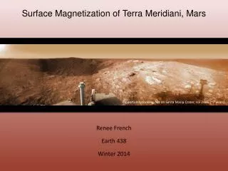
Surface Magnetization of Terra Meridiani, Mars Renee French Earth 438 Winter 2014 Opportunity looking out on Santa Maria Crater, sol 2466 (~7 years)
Motivation • Terra Meridiani has been proposed as a site of past seafloor spreading due to magnetic offsets in the MGS Magnetometer data at 400 km altitude (Connerney et al., 2005) • If this data is continued to the surface, are the magnetic offsets still observed? • Can magnetic offsets, and thus transform faults, be tied to other geologic features (i.e., offset craters, regional differences in geology)? • What other mechanisms can produce the observed magnetization? • Any other data to suggest that Terra Meridiani was once an active plate boundary? • Can data from MER Opportunity provide any ground truth for this hypothesis?
Location Image credit: NASA
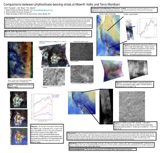
Geologic Investigation Squyres and Knoll (2005) Trough x-strat Image Credit: NASA/JPL/ASU Squyres et al. (2006) Hematite spherules Squyres et al. (2006) Image 3cm wide
Burns Formation Facies • Data best supports eolian environment with a fluctuating groundwater table McLennan et al. (2005)
Martian Magnetization From Acuñaet al. (1999): Measured vertical component of the magnetic field (no altitude correction). Includes aerobraking data. Solid line is the boundary between the northern lowlands and southern highlands.
Martian Magnetization From Connerney et al. (2005): Measured radial (vertical) component of the magnetic field at 400km altitude
Past Seafloor Spreading? Map of the magnetic field as a function of latitude (Connerney et al., 2005). Green and orange represent profiles taken to the west and east of the central meridian, respectively. Map of the magnetic field at 400 km altitude (Connerney et al., 2005). Dashed lines represent transform faults, letters refer to impact basin names.
Methods • 2D Fourier Transform • Downward continuation; k>25 filtered out • Inverse Fourier Transform • Geologic units from Scott and Tanaka (1986), Greeley and Guest (1987).
Accuracy Test Aerobraking: Max: 278 Min: -268 DC’ed: Max: 437 Min: -247
Impact influence? Basins: 1-Chryse 2- Ladon 3- Aram Chaos 4- overlapped by Newcomb 5- overlapped by Schiaparelli 6- Cassini Basins are from Schultz et al. (1982) and Schultz and Frey (1990)
Tectonic influence? “Great faults” from Connerney et al. (2005)
Topography 20N, 20E 20N, 20E 20S, 340E 20S, 340E
Geology All units are interpreted as some type of igneous rock 20N, 20E Crater materials Cratered unit Etched unit Ridged Plains material Older Channel material Ridged unit Subdued crater unit Hilly unit Ridged Plains material Chaotic material Smooth unit Crater materials Hilly unit Dissected unit Undivided material Cratered unit Mottled Smooth Plains unit Smooth unit 20S, 340E Scott and Tanaka (1986), Greeley and Guest (1987)
Discussion • Downward continued field agrees well with low altitude data. • Offsets observed by Connerney et al. (2005) at altitude are also observed at the surface • No other geophysical signature of faults • Possible influence from multi-ring basins • May not be a source of magnetization, but rather weaken the intensity • Magnetic mineralogy constrained by Opportunity • Will use when considering source models • Geologic history from Burns formation does not match a seafloor spreading environment • However, this outcrop is only 7 m thick