Addressing Data Inconsistencies in Precipitation and Streamflow in the Mekong River Basin
This study highlights the critical inconsistencies between precipitation and streamflow data in the Mekong River Basin. Utilizing the VIC macroscale hydrologic model, we discovered significant underestimations of precipitation, especially in mountainous areas, which compromised streamflow simulations. The research underscores the importance of high-quality reanalysis products to accurately assess hydrologic responses to land cover and climate change. A suggestion for a spatial resolution of 25 km or finer is made to improve understanding of runoff generation in Southeast Asia's river basins.

Addressing Data Inconsistencies in Precipitation and Streamflow in the Mekong River Basin
E N D
Presentation Transcript
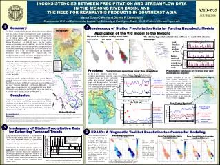
1 2 4 INCONSISTENCIES BETWEEN PRECIPITATION AND STREAMFLOW DATA IN THE MEKONG RIVER BASIN, AND THE NEED FOR REANALYSIS PRODUCTS IN SOUTHEAST ASIA Mariza Costa-Cabral and Dennis P. Lettenmaier Department of Civil and Environmental Engineering, University of Washington, Seattle WA 98195; dennisl@u.washington.edu A31D-0935 AGU Fall 2006 Summary Inadequacy of Station Precipitation Data for Forcing Hydrologic Models Topography The ability to predict the hydrologic effects of scenarios of land cover and climate change over large river basins, using macro-scale hydrologic models, is a crucial scientific challenge in the face of global change. We applied the VIC grid-based macroscale hydrologic model (Liang 1984; Nijssen et al. 1997, 2001) to the Mekong River basin (ca. 800,000 km2). For the baseline scenario, representing current conditions, we used the best land surface data available, and daily precipitation interpolated from the available meteorological stations, for 1979-2000. But in vast mountainous areas in the east-central region our streamflow simulations were compromised by unrealistically low precipitation data. In some sub-basins, precipitation totals were in fact lower than observed streamflow (panel 2). Stations data must be interpolated to the model’s grid to be used for model forcing. But stations are too sparce (see figure) considering the basin’s high relief and monsoonal precipitation regime, leading to mis-representation of mountainous areas. Detection of temporal precipitation trends over a region that might help explain observed streamflow trends is also not possible (panel 3). Comparison of the interpolated station data against ERA40 (panel 4) corroborates severe under-estimation by the stations. The difference relative to ERA40 is especially great over Burma and Laos’ Northern Highlands and Eastern Highlands – the regions where inconsistencies with streamflow had been found. While useful as a diagnostic tool, ERA40 data is too coarse to be used for model forcing (native resolution >1°). Application of the VIC model to the Mekong We used the highest quality input data: We obtained good simulated streamflows for most of the basin: River Network Soil Texture Land Cover Streamgauges Observed Simulated Good Results at most locations, e.g. these: Chiang Saen Chiang Saen Ubon But low simulated streamflows towards the mainstem south: • 1 Tibetan Plateau • 2 Three Rivers area • 3 Lancang Basin • 4 Eastern Highlands • 5 Kontum Massif • 6 Bolovens Plateau • 7 Khorat Plateau • 8 Southern Uplands • 9 Phanh Hoei Range • 10 Lowlands • 11 Cardamom Range • 12 Chao Phraya River Plain • 13 Salween River Plain • 14 Mekong Delta • 15 Malay Peninsula • 16 Yunnan Plateau • 17 Sichuan Basin • 18 Northern Highlands Stung Treng Problem: Precipitation is sometimes lower than streamflow: Precipitation estimates are too low over vast mountainous regions: In the Lower Mekong river basin, estimated precipitation totals for some tributary basins are lower, or barely higher, than observed streamflow (see graphs and the map below). Yet, runoff ratios in the region are generally below 50%, implying that precipitation must be at least double the streamflow. Daily meteo data from these stations was interpolated into the model grid using the SYMAP algorithm (Shepard, 1984). Nam Ngum Dam Catchment (ca. 8,300 km2) East-Central Region Simulated streamflow for the east-central region, encompassing the eastern mountain ranges (highlighted in the figure) is lower than observed streamflow (calculated by subtracting Ubon and Nakhon Phanom observed flows from that at Stung Treng). It also shows a rising trend that is absent from the observations. The probable explanation is lack of areal coverage by the few stations in this high-relief region (see figures in panel 1). Estimated annual precipitation (comparable to observed streamflow!) (mean: 1246 mm/y) From Goteti and Lettenmaier (2001). (1190 mm/y) Observed mean annual inflow to dam (1190 mm/y) VIC Simulated annual inflow to dam Conclusion (mean: 387 mm/y) A high quality reanalysis, at a spatial resolution which ideally would be no coarser than 25 km (exceeding the ca. 32 km resolution of the North American Regional Reanalysis), and ideally would include data assimilation, would be fundamental for understanding runoff generation in the Mekong and other river basins in Southeast Asia. Ban Keng Done Catchment (ca. 13,000 km2) East-Central Region (ca. 170,300 km2) Estimated annual precipitation (significant rising trend) Observed annual Streamflow (4 years available) Meteo Stations Observed mean annual streamflow (no significant trend) Estimated annual precipitation (lower than observed streamflow!) Acknowledgement: Financial support for this work came from the US National Science Foundation Carbon program, and in part from the Functional Value of Biodiversity Program, funded by the World Bank-Netherlands Partnership Program. We thank Jeffrey E. Richey for this support. We thank Nathalie Voisin for preparing the figures in panel 4. References: Goteti, G., and D.P.Lettenmaier (2001): Effects of streamflow regulation and landcover change on the hydrology of the Mekong river basin. Technical Report 169, Department of Civil and Environmental Engineering, University of Washington. Liang X, Lettenmaier DP, Wood EF, Burges SJ. 1994. A simple hydrologically based model of land surface, water, and energy fluxes for general circulation models. J Geophysical Research99 (D7): 14415-14428. MRC (2003): State of the Basin Report: 2003. Mekong River Commission, Phnom Penh. 300 pages. Nijssen B, Lettenmaier DP, Liang X, Wetzel SW, Wood EF. 1997. Streamflow simulation for continental-scale river basins. Water Resources Research 33: 711-724. Nijssen B, O’Donnell GM, Lettenmaier DP, Lohmann D, Wood EF. 2001b. Predicting the discharge of global rivers. J Climate14: 3307-3323. Shepard, D.S. (1984): Computer mapping: The SYMAP interpolation algorithm. In Spatial Statistics and Models, G.L. Gaile and C.J. Willmott (eds). D. Reidel Publishing Co.: Dordrecht, The Netherlands: 133-145. VIC Simulated annual streamflow (too low, and significant rising trend) VIC Simulated annual streamflow 3 Inadequacy of Station Precipitation Data for Detecting Temporal Trends ERA40 : A Diagnostic Tool but Resolution too Coarse for Modeling Long-term trends were detected in the streamflow records of the Mekong River basin (see figure). These trends may be due in part to a) precipitation trends; a) land cover and use changes; c) air temperature changes; d) measurement methods. Unfortunately, the network of meteo stations (see panel 1 above) is too sparce to provide reliable areal precipitation estimates. Hence, the contribution of possible precipitation and temperature trends to the detected streamflow trends cannot be determined. An analysis of existing rainfall records since 1950 found no trends consistent with the streamflow trends (MRC, 2003). Stations and ERA40 estimates of mean annual precipitation are compared in the figure. ERA40 is roughly 60% higher than stations data over a large region that includes Burma, the Northern Highlands of Laos (i.e., latitude 17°N to 23°N) and the eastern part of Thailand’s Khorat Plateau. ERA40 is however roughly 30% lower over Southern Cambodia and the Vietnam Delta. ER40’s native resolution is slightly coarser than 1°, too coarse for hydrologic models. Mean Annual Precipitation in 1979-2000: Mean Precipitation in March:(large difference) Mean Precipitation in November:(smaller difference) mm/day mm/day The largest differences between ERA40 and stations precipitation estimates are for the dry season months January-April, where ERA40 values are several-fold higher, over nearly all of the basin’s area (figures to the right). ~ In the annual time series of Mekong streamflows for individual months, we encounter significant trends predominantly in dry-season months November-May. The trend direction differs between regions. Stations and ERA40 data were interpolated to 0.25° and 0.5°, respectively, using the SYMAP algorithm (Shepard, 1984).