Download
1 / 37
370 likes | 515 Vues
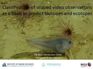
Classification of seabed video observations as a basis to predict biotopes and ecotopes. Pål Buhl-Mortensen (IMR) Margaret Dolan (NGU). Nature.

E N D
Classification of seabed video observations as a basis to predict biotopes and ecotopes Pål Buhl-Mortensen (IMR) Margaret Dolan (NGU)
Nature Nature is a general and scale-independent term referring to a specific area including the species living there and the environment surrounding them, or the environment alone Nature type (”Biotope”) • a homogeneous type of nature, which embraces all plant and animal life and the environmental factors acting there. • Nature types are generally home to a unique combination of species that reflects the local environmental conditions. http://www.artsdatabanken.no/
Video/camera-platforms ROV (Remotely Operated Vehicle)Towed platforms/drop camerasManned submersibles
Recognition/definiton of habitats and biotopes in deep water • Few existing habitat classes • Deep sea less homogenous that perceived • Many new nature types • How to define?
Nature types in the MAREANO-area Identified with DCA of results from video analysis of 200 m sequences analysed in field (landscape level) and post cruise (ecosystem level) Landscape/landscape element level Ecosystem level Sponge habitats on sandy mud, Sand, Gravelly sand, Gravel, Moraine ridges Bank Sedimentation- bassain Fine mud, Seepages (Pockmark)* Shelf trough (marine valley) Fine mud, Sand, Gravelly sand, Coral reef*, Seepages (Pockmark)* Shelf break Uppercontinentalslope Gravelly bottom with soft corals ++ Lowercontinentalslope Consolidated mud with large glass sponges, Fine deep sea mud, ++
Analysis of videotransects Video-sequences: Average length = 12 m Video transect divided into sequences: • Counting of individuals an colonies • Estimation of % coverage of bottomsubstrates and encrusting organisms • Quantification of human impact: • damaged organisms • trawlmarks • lost fishing gears • garbage 100 m
Recording of video and additional data
Video-signal Monitor Integration of stored data and image analysis Semi- automatical extraction of data Synchronization Stored data: Time Position Depth Altitude Pitch Extracted data: Taxon, Abundance, Bottom type, Cover, Position, Depth, Estimated area ….
HabiMap File Edit View Insert Format Tools N 7052000 Depth 150 E 576000 Time 03:27:56 Sequence 56.5 m Area 112,7 Start new sequence Pause Stop registration Main bottom type: Mud….78 Bottomtypes % cover Predefined bottomtype A <10 10-25 25-50 50-75 75-90 90-100 …. Predefined bottomtype B <10 10-25 25-50 50-75 75-90 90-100 …. New bottomtype: ……….. <10 10-25 25-50 50-75 75-90 90-100 …. Taxa Counts and % cover Predefined species A (n) 1 2 2-5 5-10 10-20 ……. Predefined species B (n) 1 2 2-5 5-10 10-20 ……. Predefined species C (%) 1 2 2-5 5-10 10-20 ……. New species A: …………. 1 2 2-5 5-10 10-20 ……. New species B: …………. 1 2 2-5 5-10 10-20 ……. New species C: …………. 1 2 2-5 5-10 10-20 …….
Variables derived from multibeam echosouder (naturetype indicators) • Depth • Terrain • Slope • Aspect • Curvature • Rugosity • ++ • Backscatter
General procedure for characterization and prediction of habitats • Multivariate analysis of species data from bottom video-surveys to find groups of locations that are similar with respect to composition of species. • Identification of environmental variables (e.g. Depth, surface sediment composition, topography, etc) that best explain the composition of species identified on video records. • Comparison of the explanatory ability of variables derived from the MBE data-set and parameters collected by means of visual inspection. • ”Supervised” GIS analysis for classification with full areal coverage (Maxent). • Presentation of the general biodiversity of habitats based on species composition in samples collected with different bottom sampling gears.
MAREANO mapping areas Barents Sea Tromsøflaket Norwegian Sea
Shallow banks (50-200m) Trench with strong currents (200-300m) Andøy Hola Bleiksdjupet Canyon Continental slope (1000-1500m) Continental slope (1500-2000m)
Surveyed locations 2008 Grovinndeling av marine landskap
60 55 50 45 40 0 35 NCW 200 30 Number of taxa Depth (m) 25 400 NAW (>0,5 °C) 20 600 Watermasses 15 10 800 NSAIW (-0,5 - 0,5 °C) 1.0 5 NSDW (-0,5 - 1,5 °C) 0 2400 0.8 0.6 Bottom types (frequency of occurrence) 0.4 0.2 0.0 Bank Canyon Fjord/coast Upper slope Shelf trough Mid and lower slope Shelf terrace Slope terrace Deep-sea plain Shelf trough fan Consolidated mud Sand Gravel Mud Gravelly sand Boulder Sandy mud Sandy gravel Bedrock
DCA of field observations, cruise 2008104 june 2008 Landscape 266 Clasification of locations based on DCA groups 265 Fjord/Coast Shelf break Shelf trench 267 246 Fan 201 217 Bank Shelf terracee Bank Slope terrace 254 Upper slope Lower slope 255 226 215 Upper slope 218 224 239 Lower slope 261 253 225 264 240 198 229 Canyon 202 256 241 Deep sea plain 270 245 252 211 228 247 233 235 Gravel Axis 2 238 268 244 251 Depth Gravelly 234 263 212 249 250 237 Mud Sandy mud 213 Sand 260 257 195 236 232 269 210 209 219 231 262 203 200 230 199 258 259 242 271 197 243 204 227 248 208 221 222 205 Shelf trench 207 223 206 196 220 Axis 1
DCA hele egga 09 2 Type 1 2 3 4 5 6 7 8 Axis 2 Axis 1
Coral Gravel Sand Sandy mud Mud 3 Sand 2 Sandy mud Coral 4 Gravel 5 Gravelly Sandy mud 1 Mud
Calcareousforaminifera. Aplysilla. Geodia PelosinaAsbestopluma. 2 1 Sandy mud Fine-grained mud 4 3 Sand Gravelly sand Aphrodite, Stylocordyla Bolocera. Sticopus 6 5 Morainic rocky ridges Bouldery bottom Polymastia. Antho Brachiopoda. Phakellia
Nature type prediction on Tromsøflaket, western part Using same predictors as for the eastern part 1 – Mud in bassain, with pockmarks 2 – Sandy mud, with iceberg ploughmarks 3 – Sand/mud, on level bottoms 4 – Gravelly and sandy sediments in gently sloping areas 5 – Gravelly and sandy sediments, with iceberg ploughmarks 6 – Gravelly and sandy sediments, with boulder on morainic ridges
Prediction in ”new” marine landscapes • Sources to ecosystemvariation: • Terrain and landscape • Watermasses (temperature, salinity, etc) • Sediment composition • Bottomcurrents • Nutrientsupply • Different regions often have differentenvironmentalconditions • MBE-derivedpredictorsmaychange ”meaning”