Download
1 / 17
170 likes | 283 Vues
This report provides an analysis of Hurricane Gonzalo as it made landfall near Bermuda on October 17-18, 2014. Initially a strong Category 3 hurricane, Gonzalo weakened to a Category 2 as it passed over the island. The report details wind patterns, including significant east winds before the eye passed over Bermuda, and the highest recorded gusts. The impact on local infrastructure, such as the Causeway, is discussed alongside technological observations from weather sensors. Key comparisons with previous hurricanes and data challenges are also noted.

E N D
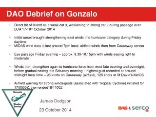
DAO Debrief on Gonzalo • Direct hit of Island as a weak cat 3, weakening to strong cat 2 during passage over BDA 17-18th October 2014 • Initial onset brought strengthening east winds into hurricane category during Friday daytime • MIDAS wind data is lost around 7pm local, airfield winds then from Causeway sensor • Eye passage Friday evening – approx. 9.30-10.15pm with winds easing light to moderate • Winds then strengthen again to hurricane force from west late evening and overnight, before gradual easing into Saturday morning – highest gust recorded at around midnight local time – 98 knots on Causeway (airfield), 125 knots at St David’s AWOS • Airfield warning for strong winds/gusts (associated with Tropical Cyclone) initiated for 17/0000Z, then ended18/1100Z James Dodgson 23 October2014
BWS TUBs – Cat 3 at 6pm weakening to cat 2 at 9pm on Friday 17th
Points to consider • Swell direction shift • - East swell/wind rather than SE – less impact on Causeway – Need buoy to verify sea/surge • Technology of weather sensors • Causeway sensors ultra-sonic, only issue was power supply • (future technology on the runway? - 10yr old equipment goes U/S during initial eye wall) • Comparison with other hurricanes • Can not fully compare with previous hurricanes • - Synoptic situation different – behind Fay / structural improvements since Fabian • Potential - Evacuation and loss of data from BWS – roof damage / window blowout
East wind & swell
Causeway Impact Gonzalo and that High & the front were in a scrum... we were forecasting SE, worst direction for broadside impact on Causeway, but that stubborn High squashed the NE quadrant so much that we had long duration East winds ahead of the eye. East winds & swells meant that the finger took the brunt of the water action & buffered most of the Causeway except the corner down by Blue Hole... where those side walls came down.
BWS makes Met history: very rare to release a weather balloon in hurricane eye
Hurricane Hunter flight path in Gonzalo earlier on 17 October Interesting loops here where plane flew around the eye
Northern eye wall radar image – coincided with strongest E winds
Northern eye wall clearing, temporary improvement as eye moves in
South side – Feeder Rain Bands & Eye wall replacements; transition from Cat 3 to Cat 2 due to cooling sea surface temperatures and vertical windshear – gradual loss of tropical characteristics
Pressure trace showing barometer falling close to 952mb/28.12inches Timeline shows Gonzalo impacts for 24hrs plus
Title 24 hours 15 hours 12 hours ** 4 hrs Cat3 - Cat2 Eye approx. 45 min
TAFs issued through duration of Gonzalo TAF AMD TXKF 172135Z 1721/1818 13045G55KT 4800 RA SCT008 OVC012 TEMPO 1721/1806 3200 RA BKN008 OVC012 PROB40 TEMPO 1721/1806 1600 +SHRA BKN008 OVC012CB PROB30 TEMPO 1721/1806 0800 +TSRA SCT005 OVC008CB BECMG 1721/1722 14065G90KT 3200 BLPY BKN008 OVC012 BECMG 1722/1724 15090G120KT TEMPO 1723/1801 VRB25KT BECMG 1800/1802 27090G120KT BECMG 1802/1804 27065G90KT BECMG 1804/1806 27045G65KT 6000 -SHRA BKN015 BECMG 1806/1808 29025G35KT BECMG 1812/1815 27015G25KT 9999 NSW SCT015 BKN065 BECMG 1815/1818 27015KT TAF details included blowing spray (BLPY) as well as hurricane force ESE winds ahead of eye, then eye conditions (shaded above) followed by hurricane force W/WNW winds behind eye as Gonzalo gradually moved away NE
Thank you for your attention Any Questions?