Download
1 / 18
180 likes | 356 Vues
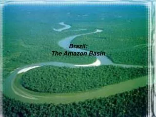
Ethnogeology applied to mapping and water resource management in the NW Amazon basin, Colombia. Sandra.londono@asu.edu. . Londo ño S.C*, Garzon N.C, Semken S., Brandt E. . Ethnogeology. Study of cultural-based understanding, assessment, and use of geological knowledge. Ethnography.

E N D
Ethnogeology applied to mapping and water resource management in the NW Amazon basin, Colombia Sandra.londono@asu.edu . Londoño S.C*, Garzon N.C, Semken S., Brandt E.
Ethnogeology • Study of cultural-based understanding, assessment, and use of geological knowledge. Ethnography Cañon de Araracuara, Caquetá, Colombia
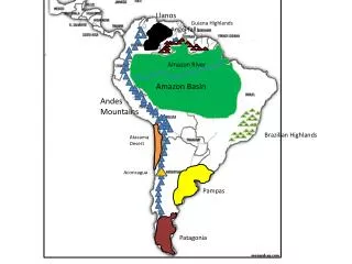
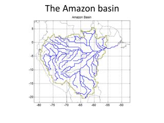
Ethnogeology applied to water resources in the NW Amazon basin COLOMBIA PERU Limits of thePredio Putumayo (Reservation) Our principal goal was to better serve needs and concerns of this native community in their homeland region.
Workshop The Water World. –A dialogue between Native and Earth Sciences. PAR Approach • Offer basic conceptual tools from geology to understand the study of water and fluvial systems. • Identify perceptions, problemsand concerns related to the water resource. • Initiate a process of proposal writing.
Moniya Amena. The Tree of Abundance. “The giant tree fell, its base is the water of the dawn, the big water, trunk forming the Amazon, its big branches forming the main tributaries,. The fruits of the tree became fishes, some say the leaves became the forest. It is the origin of the rivers and its creatures” MoniyaAmena. Uitoto Myth This transversal myth the tree metaphor is used to obtain relatively rich knowledge about the river environment.
The River is a Tree • Metaphor theory (Lakoff & Johnson, 1980). The tree is an organizing principle. Mapping of the source domain (tree) into the target domain (river system) produces relatively rich knowledge and understanding of the target domain. Ex. Explains drainage pattern. Explains ecological relationships: fishes are fruits of the tree. Reveals the native conception of the river as a mega-organism.
Types of Water Native Science Western science: Sioli 1984
The Water World For the Uitoto, the water is a world on its own. It has its own “people” (BuinaUruk+) that in turn, have their own fruits, medicines, and malocas (dwellings). The water malocas are located in rapids. The foam of the river are the clouds of the water world. The shaman is the intermediary between the humans and the buinaimas so the two worlds coexist in a reciprocal relationship. (=Sustainability)
Recent alluvial deposits. Can be aquifer Clay beds with ferric nodules. Sandstone beds with bioturbation. Equivalent to Pebas Fm. And Mariñame sandunit. Conglomerates at the top. Micaceoussandstones, red, yellow, colorsintercalatedwithmuddysandstones and greenarcillolites. Basement: migmatites, paragneisses, schist, locallycutbydoleritic and basalticintrusions Estratigraphic Column from Araracuara, North of the Area.
Geomorphology Dominated by sedimentary dissected plains that give rise to an undulated plane. Average height 90m above sea level. Fluvial planes of black rivers, terraces systems. Hard rock elevations to the North. Island-hills. Rapids. . s Juma Rapid Isolated topographic heights . high plains Dissectedsedimentary plains LowTerracesystem
Watersheds Identifying sub-basins can help determine theunit of analysisfortheplaning and management of theresource and territory
Contributions to the “Plan of abundance, Plan of Life” • Maps of hydrology with traditional names • Geomorphology maps • Identification of sub-basins. • Considerations about ground water systems and the implications in land planning.
Conclusions • Knowledge exchange between natives and geologists can provide a sound basis for sustainable natural resource management in tribal lands. • There is a rich, interconnected and deep cultural Uitoto knowledge related to water that can enhance our understanding of natural processes in Amazonia • With an ethnogeology approach, support and coaching from education centers like National University can encourage cultural preservation while prommoting development and empowerment of indigenous communities in Colombia. • In places of high cultural diversity, ethnogeology offers an exciting area of research.
Acknowledgments • GPSA Independent Research grant 2012-2013 • Gil Farékatde • AZICATCH