Download
1 / 14
140 likes | 211 Vues
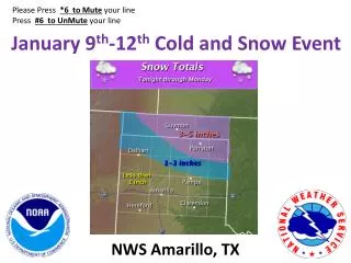
Please Press * 6 to Mute y our l ine Press # 6 to UnMute your l ine. January 9 th -12 th Cold and Snow Event. NWS Amarillo, TX. Changes from Yesterday. Freezing drizzle may develop over the Panhandles Sunday Afternoon through Monday, particularly over the Eastern Panhandles.

E N D
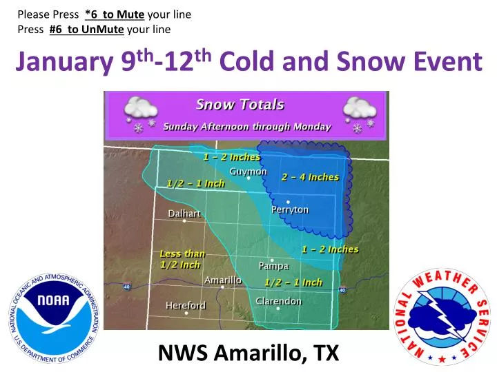
Please Press *6 to Muteyour line Press #6 to UnMuteyour line January 9th-12th Cold and Snow Event NWS Amarillo, TX
Changes from Yesterday • Freezing drizzle may develop over the Panhandles Sunday Afternoon through Monday, particularly over the Eastern Panhandles. • Snow will mainly hold off until midnight Sunday night in most locations.
Snow Event • Snow may begin across the northeastern half of the Panhandles Sunday afternoon. Snow will spread over the entire area Sunday night and Monday, mainly between midnight and 6 pm. • Heaviest snow Sunday night and Monday expected across the northeastern Panhandles. • Southeasterly/Easterly winds 15 to 25 mph with higher gusts Sunday night will become northerly Monday 20 to 30 mph with higher gusts. • Blowing and drifting of the snow and reduced visibilities expected at times.
Temperature Summary • Arctic front blasts through the region late Sunday night into Monday morning. • Bitterly cold temperatures expected Monday through Wednesday, particularly on Tuesday. • Some places may remain below freezing for up to 90 hours. • Northerly winds will produce dangerously low wind chill values WIND CHILLS ***Lowest wind chills Tuesday and Wednesday mornings***
Confidence • Storm Track – High • Precipitation Type – Moderate (Possibly beginning as drizzle or freezing drizzle turning over to mainly snow) • Snow Timing – Moderate (begins Sunday afternoon/evening and ends Monday afternoon) • Strong Winds – High (Northerly winds 20 to 30 mph with higher gusts) • Blowing and drifting snow expected • Snowfall amounts – Low • Due to location of heaviest band and moisture quality • Dangerously Cold Wind Chills – High • Especially Tuesday and Wednesday mornings
Impacts • Travel concerns mainly across the northeast half of the Panhandles due to possible snow covered roads on: • All Highways and Surface Streets • Visibility restrictions due to the falling and/or possible blowing and drifting of the snow • Dangerously cold Wind Chills Monday through Wednesday mornings • Especially Tuesday and Wednesday mornings