Download
1 / 13
130 likes | 294 Vues
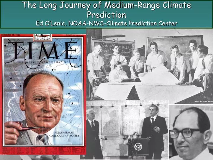
The Long Journey of Medium-Range Climate Prediction Ed O’Lenic, NOAA-NWS-Climate Prediction Center. Outline: Medium-range climate prediction is a work-in-progress…. History Introduction to medium range forecasts Motivation Current MR climate forecast methods

E N D
The Long Journey of Medium-Range Climate PredictionEd O’Lenic, NOAA-NWS-Climate Prediction Center
Outline: Medium-range climate prediction is a work-in-progress… • History • Introduction to medium range forecasts • Motivation • Current MR climate forecast methods • Model-observations calibration • Future
Historical Outline • MIT, USWB - Rossby ca. 1935-40 • Long wave theory • Slow changes in the position of the Aleutian/Icelandic centers of action • Zonal index • 1-5 day forecasting – MIT, USWB 1941-1972 (Namias). • First NWP models – 1950-53. • 6LPE, 3LPE, 7LPE + barotropic extension – 1976-78. • First 6-10-day average T, P forecast, Dec 1977. • Global Spectral Model – August, 1980. • Simmons, Wallace, Branstator, 1983 - teleconnections ~ excited by internal dynamics and boundary forcing. • Hughes – quantitative verification – 1980-1992. • Operational ensemble forecasts available – 1990. • Grease pencils-to-work-stations, verifications, new tools - 1990-2000. • Probabilistic, daily 6-10-, 8-14-day forecasts – 2000. • 2003 - Begin use of CDC calibration of MRF model.
500 hPa height and anomaly Medium range forecasts of 5-day average 500 mb heights and anomalies and categorical surface temperature (T) and precipitation (P), at a lead of 5 days (6-10 day forecasts) have been prepared operationally since late 1977. 3-class T probabilities Medium range 7-day mean forecasts at a lead of 7 days (8-14-day forecasts) have been produced operationally at CPC since 2000. Both forecasts are deterministic for 500 mb and probabilistic for T, P.
History of skill 1977-2004 6-10 day forecasts - Skill of 6-10 day forecast has been rising steadily since 1980, when the global spectral model was implemented.- Large/small-scale spatial patterns lead to large/small skill variability in T/P.- Large inter-annual T skill variability.- Skill leveled-off beginning in 1990 for P and 1991 for T.- Drop in P skill in 1999-2000 due to the loss of all P forecast tools in the Cray fire of Sep 27, 1999 and, in Feb 2000 to a change in forecast format from categorical to probabilistic. CRAY FIRE SEP 27, 1999
Temporal standard deviation of winter- time 500 hPa height computed from daily time series over 20 years. Monthly – Seas. ave data Daily – weekly ave data The lion’s share of 500 hPa height variability found for time scales of weekly averages. Weekly - Mo ave data Seasonal ave data Blackmon and Wallace
6-10-Day Forecast Process in 1979: (1) PREDICT 500 HPA HEIGHTS AND ANOMALIES (2) DOWNSCALE: Klein equations. (3)FINAL FORECAST Categorical 5-class T, 3-class P, CONUS only Forecast tools Composite 500 hPa hgt barotropic + 3LPE extended to 240hrs from7LPE 84hr forecast
(3) ESTIMATE UNCERTAINTY • DOWNSCALE T & MODEL OUTPUT P: • Klein equations, • Natural analogs • CDC-Calibrated MRF T, P • Neural Network for each • GFS ENS member + • CAN, ECMWF, BAR, ENS 6-10-, 8-14-Day Forecast Process in 2004: Obs/Fcst freq/probs calib??? (1) PREDICT 500 HPA HEIGHTS AND ANOMALIES 500 hPa height multi-model composite GFS ENS, CAN ENS, ECMWF ENS, Barotropic, 06-12-18-00 Z GFS Forecast tool maps ~30/variable (4)FINAL FORECAST
A comprehensive skill evaluation system continually informs forecasters
Calibrate the observed frequency of the above and below categories with probabilities from 15-member daily ensembles over 23 yrs using the 1998 MRF, initialized from reanalysis. This simple technique improves week 2 RPSS from zero to +0.20 and improves forecasts of extremes. Runs every 5-days for 20 years would use equivalent of 4 years of daily forecasts. Considering the pay-off and user requirements for accurate estimates of uncertainty, shouldn’t this should be a routine part of model-change-implementation? Hamill, T.M., J. S. Whitaker, and X. Wei, 2004: Ensemble re-forecasting: improving medium-range forecast skill using retrospective forecasts. J. Climate, June, 2004.
Composite Madden-Julian Oscillation and tropical storm origination points MJO is related to heavy precipitation events in the Northwestern United States R. Wayne Higgins – CPC
Summary • Rossby, Namias – NWP, Charney, Phillips - Ensembles • Most 500 hPa variability is in weekly average data. • Skill of MR forecast closely related to NWP and computing ability. • Value and protection of life and property – why we do 6-10-day and week-2 forecasts – most popular CPC products. • Current MR forecast methods are ensemble-model-based. • Calibration greatly improves ENS MR probabilistic forecasts. • Ensembles of ensembles from different models (MM ensembles) are better than single-model ensembles. • Better modeling of global tropics -> MJO, diurnal cycle of convection -> better week 2 & week 3, 4 forecasts. • Better prediction of odds of extreme events. • Prediction of a wide array of parameters beyond T, P.
Medium range climate prediction is a work in progress. It has come a long way. Thanks to Rossby’s vision and NWP, It is alive, well and has a promising future.