Download
1 / 38
380 likes | 501 Vues
Hydrologic Conditions in the Palouse Aquifer. Dale R. Ralston Professor Emeritus of Hydrogeology University of Idaho. Outline of talk. Introduction Ground water management concepts Description of the Palouse aquifer Well development and water level decline

E N D
Hydrologic Conditions in the Palouse Aquifer Dale R. Ralston Professor Emeritus of Hydrogeology University of Idaho
Outline of talk • Introduction • Ground water management concepts • Description of the Palouse aquifer • Well development and water level decline • Research and management activities • Water management questions
Ground Water Management Concepts INFLOW STORAGE OUTFLOW INFLOW - OUTFLOW = 0 Long-Term Equilibrium - Recharge Equals Discharge
Ground Water Management Concepts Water levels are stable prior to development or when pumping amount is small Water Level Time (years)
Ground Water Management Concepts Addition of Pumping Can Result in a New Equilibrium Withdrawal INFLOW STORAGE OUTFLOW Water levels decline until inflow = outflow + withdrawal
Ground Water Management Concepts Development of well(s) with a constant pumping rate can result in water-level decline leading to a new equilibrium Constant pumping rate Aquifer water level Time
Ground Water Management Concepts Development of wells with a increasing combined pumping rate will result in continual water-level decline Increasing pumping rate Aquifer water level Time
General Geologic Setting Subsurface geology of the Palouse basin is dominated by basalt with layers of sediment, mostly along the east margin Basalt and sediment overlie older rocks that make up Moscow Mountain and Paradise Ridge
Wanapum Formation: Priest Rapids Member • Wanapum Formation is the uppermost basalt unit in the Palouse basin • Priest Rapids member is present in most areas with the Rosa member present west of Pullman • This formation hosts the upper aquifer in the Palouse basin
Grande Ronde Formation • Grande Ronde basalt makes up the majority of the subsurface section in the Palouse basin and other locations in Eastern Washington and Northern Idaho • Formation is divided into four units based on paleo-magnetism • This formation hosts the lower aquifer in the Palouse basin and is the major water producer in Lewiston and in the Grangeville area
46.7º N WGS84 117º W N 1 2 0 3 miles 117.2º W Pa 46.9º N 1500 Ringo Butte C Kamiak Butte Smoot Hill 2000 Moscow Mountain M 1000 P 500 Tomer Butte 1500 Bald Butte Pre-Basalt Topography
WGS84 117º W 117.2º W 46.7º N N 1 2 0 3 miles Pa 46.9º N Ringo Butte C Kamiak Butte Primary dip Extent of R1 flows Sedimentation ? ? Smoot Hill Moscow Mountain M P Tomer Butte Emplacement from SW Bald Butte Geology After First Sequence of Grande Ronde Basalt
WGS84 117º W 117.2º W 46.7º N N 1 2 0 3 miles Pa 46.9º N Ringo Butte C Kamiak Butte Primary dip Extent of N1 flows Sedimentation ? ? Smoot Hill Moscow Mountain M P Tomer Butte Emplacement from SW Bald Butte Geology After Second Sequence of Grande Ronde Basalt
46.7º N N 1 2 0 3 miles WGS84 117º W 117.2º W Pa 46.9º N C Ringo Butte Kamiak Butte Smoot Hill Moscow Mountain M P Basalt Flow Direction Tomer Butte SNAKE RIVER Bald Butte Geology After Third Sequence of Grande Ronde Basalt
46.7º N WGS84 117º W 117.2º W ? Pa 46.9º N C Ringo Butte Kamiak Butte Smoot Hill Moscow Mountain Basalt Flow Direction M P Tomer Butte SNAKE RIVER Flow Direction Bald Butte Geology After Fourth Sequence of Grande Ronde Basalt
Area Hydrogeology - 1 • Upper aquifer occurs in the Wanapum Formation • Lower aquifer occurs in the Grande Ronde Formation • Depth to water in upper aquifer is about 60 feet while the depth to water in the lower aquifer is about 300 feet
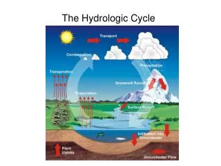
Area Hydrogeology - 2 • Recharge to upper aquifer occurs from infiltration of precipitation and stream loss • Recharge to lower aquifer occurs primarily as downward leakage from upper aquifer • Recharge to the upper aquifer is greater than to the lower aquifer although present estimates of recharge rates have large error band
Well development -- 1 • In Moscow, the upper aquifer water levels declined until 1960’s when deep wells were drilled and withdrawal was shifted to lower aquifer – water levels now have recovered to 1940’s levels • City of Moscow now withdraws about 30 percent from the upper aquifer
Well Development -- 2 • Water level decline has been experienced in the lower aquifer in Moscow, Pullman and Palouse • There is considerable evidence that these three cities obtain water from the same aquifer system
Water Levels from Grande Ronde wells in Moscow and Pullman WSU test M-8 M-9 UI-3 P-3 P-4 M-6 Moscow Wells Pullman Wells
Research and Water Management Activities • Ground water model (1990) • PBAC (Palouse Basin Aquifer Committee) formed and developed plan • Pumping from the Grande Ronde aquifer has been stabilized • Additional research on geology, water ages and water level patterns
Ground Water Model (1990) • Cooperative effort of USGS and UI • Represent upper and lower aquifers • Primary results • Ground water levels will continue to decline if pumping amounts continue to increase • Ground water levels will stop declining (within 10 to 15 years) if pumping is stabilized
Palouse Basin Aquifer Committee (PBAC) -- 1 • Includes cities, Universities and counties from both states • General goal is to ensure a long-term water supply for the basin • The goal of stabilizing pumping from the lower aquifer was accomplished in the 1990’s • In 1999, PBAC’s revised goal was to stabilize ground water levels in lower aquifer by 2020 by conservation and possible recharge enhancement • PBAC has supported and encouraged water conservation and aquifer research
Palouse Basin Aquifer Committee (PBAC) -- 2 • Ongoing research projects at both UI and WSU (geology, water levels, age dating of water) are leading to an improved understanding of the aquifer. • Plans are underway to construct several test wells in areas where geologic and hydrologic data are limited. • $100,000 federal appropriation, in process, will allow additional research.
Water Management Questions -- 1 • Is the deep aquifer in the Moscow area part of a larger aquifer system that includes Pullman and Palouse and possibly Colfax and Garfield? Yes – the areas are hydraulically connected. • Does this aquifer receive recharge? Yes – although we do not know if the recharge rate is greater than or less than the combined pumping rate of the four entities.
Water Management Questions – 2 • Are we facing the loss of our water supply source in the near future?No – the quantity of water still in storage in the aquifer is large. However, we need to continue to take action to insure that we have a sufficient water supply into the future.
Water Management Questions -- 3 • Is water conservation a long-term solution for the aquifer problem? Water conservation is important but may or may not be enough to insure that the area has a stable water source for decades into the future.
Water Management Questions -- 4 • What can we do if stabilizing pumping does not stabilize water levels? PBAC is now investigating recharge enhancement alternatives and encouraging entities to turn to alternative sources of water.
Water Management Questions -- 5 • Should water management activities be done separately by each of the states or as a combined effort? Since the same aquifer underlies both states, it makes sense to have combined management of the resource.