Download
1 / 12
120 likes | 128 Vues
North American Land Surface Albedo Dynamics from Landsat and MODIS/VIIRS. Crystal Schaaf 1 , Angela Erb 1 , Qingsong Sun 1 ,Yanmin Shuai 1 Zhuosen Wang 2 1 School for the Environment, University of Massachusetts Boston http://www.umb.edu/spectralmass

E N D
North American Land Surface Albedo Dynamics from Landsat and MODIS/VIIRS Crystal Schaaf1, Angela Erb1, Qingsong Sun1,Yanmin Shuai1 Zhuosen Wang2 1School for the Environment, University of Massachusetts Boston http://www.umb.edu/spectralmass 2NASA Goddard Space Flight Center, Greenbelt MD
Landsat Albedo • North American Albedo for the MODIS/VIIRS era • Concurrent approach (Shuai et al., 2011) links similar locations of MODIS(VIIRS) and Landsat to assign BRDFs to Landsat pixels • Yanmin Shuai has just joined UMassBoston • Current algorithm implementation efforts this year • Implementing processing chain improvements • Automating mosaicking, masking and sub-setting of daily MODIS inputs for linkage with Landsat scene • Overlapping processing to reduce impact of scene boundaries • Investigating use of WELD processing • Large area processing (limited thus far availability of MODIS V006) • MODIS V006 processing is underway • Daily MODIS BRDF (MCD43) is just about to be released • VIIRS BRDF/Albedo/NBAR algorithm is being tested
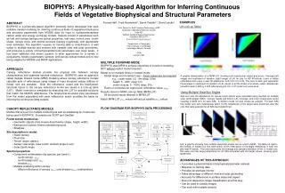
Current Algorithm Ancillary Products Primary Products Surface Reflectance Barrow SURFRAD Flux Site Landsat 8 2014 DOY: 098 Broadband Black Sky Albedo Classification File Broadband White Sky Albedo Quality Flag File Full Expression Blue Sky Albedo
Current Evaluation Efforts: • Established Narrow to Broadband coefficients (N2B) for L8 • Convert the spectral albedos to the broadband albedos • used in surface energy models • measured at tower sites with paired pyranometers • Established Full Expression Blue Sky Albedo algorithm for L8 • Blue Sky (actual) albedo is a combination of Black Sky albedo and White Sky albedo as a function of atmospheric optical depth (incorporating multiple scattering) • Validation of N2B and Blue Sky Albedo over tower sites • Spatially representative sites (including Sentinel-2A) • Sadly not the Finnish forested site • Improved L8 radiometry and validation over snow • Establishing effects of land cover change on Albedo
Generation of narrow to broadband conversion coefficients: • - Several Approaches investigated ●Hyperion ●AVIRIS • ● Spectral Library (Snow/Snow Free/Combined Coefficients)
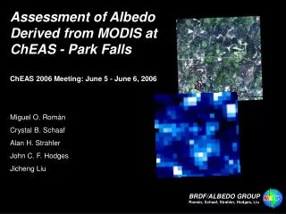
Narrow to Broadband Coefficients – Landsat 8 Spectral Library Landsat 8 Spectral Library R2 = 0.9970 RMSE- 0.01373 *Currently under validation
Generation of Full Expression Blue Sky Albedo • Using method presented in Román et al, 2010 • MODTRAN generated pre-defined look up tables for all Landsat platforms • Uses hierarchical MODIS Aerosol Optical Depth data, MOD08 (Remer et al, 2005) • Daily / 8-day/ Monthly • Where no acceptable values found, fill value of 0.2 • Improved validation results over Isotropic blue sky albedo
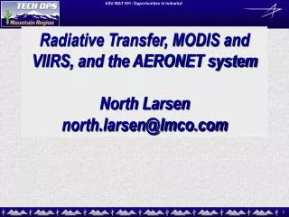
Full Expression Blue Sky Albedo of Landsat 7 and 8 Landsat 7 Full Expression Blue Sky Albedo LE7079010 2014 DOY: 090 Green= Unsaturated values Black = Saturated Values > 1.0 Landsat 8 Full Expression Blue Sky Albedo LC8079010 2014 DOY: 098 Green= Unsaturated values No saturated values
Validation of Landsat Blue Sky Albedo Barrow, AK (BSRN) Tundra Imnavait, AK (AON) Tussock/Tundra Morgan Monroe State Forest, IN (Ameriflux) Deciduous Broadleaf Forest Table Mountain, CO (SURFRAD) Grassland Sioux Falls, SD (SURFRAD) Grassland
Current Landsat Projects include: • Fire Recovery Albedos in Alaskan boreal regions • Focus on snow and winter albedo • Temporal dynamics • Albedo as a tool for forest management protocols in New England forests • Albedos related to carbon stock management in Pacific Northwest Burn Scar recovery dynamics as function of burn severity Within scar Landsat 8 albedo variability
Current Landsat Projects include: • Slope Phenology, Acadia Maine • Incorporating STARFM • Characterizing Salt Marsh Dynamism with Landsat 8, Terrestrial Lidar and G-LiHT • Plum Island LTER