Download
1 / 11
110 likes | 286 Vues
by Dr. Kamal Jain* and Mandla V. Ravibabu** Geomatics Engineering Section, Civil Engineering Department, Indian Institute of Technology Roorkee, India. : * kjainfce@iitr.ernet.in , ** ravi.mandla@gmail.com. MAPINDIA-2008.

E N D
by Dr. Kamal Jain* and Mandla V. Ravibabu** Geomatics Engineering Section, Civil Engineering Department, Indian Institute of Technology Roorkee, India. :*kjainfce@iitr.ernet.in,**ravi.mandla@gmail.com MAPINDIA-2008 11th Annual International Conference and Exhibition on Geospatial Information, Technology and Application, Paper Reference No.: MI08 PN 322 Accuracy issue of DTM available with DEPARTMENT OF CIVIL ENGINEERING
Definition Where it will use What information it will give MAPINDIA-2008 11th Annual International Conference and Exhibition on Geospatial Information, Technology and Application, About Digital Terrain Model (DTM) DEPARTMENT OF CIVIL ENGINEERING • Google earth has revolutionary mapping, science • Providing satellite images and digital elevation of the earth • free to all users directly on their desktop
Accuracy aspect on DTM extracted from Google earth To extract DTM using AutoCAD Civil 3D Analyze the usefulness the height information for spatial community. MAPINDIA-2008 11th Annual International Conference and Exhibition on Geospatial Information, Technology and Application, Objective DEPARTMENT OF CIVIL ENGINEERING
Surface 1 Surface 2 Surface 3 Surface 4 Surface 5 Scale 1:50,000 1:40,000 1:30,000 1:20,000 1:10,000 MAPINDIA-2008 11th Annual International Conference and Exhibition on Geospatial Information, Technology and Application, Extracted Surface from different terrains DEPARTMENT OF CIVIL ENGINEERING Table 1 shows various surfaces with scale extracted from Google earth
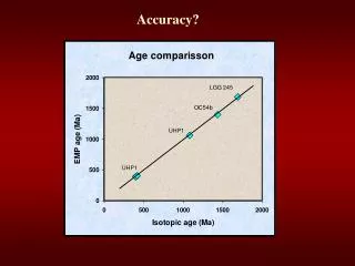
MAPINDIA-2008 11th Annual International Conference and Exhibition on Geospatial Information, Technology and Application, Z values variation on different sites DEPARTMENT OF CIVIL ENGINEERING
MAPINDIA-2008 11th Annual International Conference and Exhibition on Geospatial Information, Technology and Application, Z values variation on different sites DEPARTMENT OF CIVIL ENGINEERING
g h MAPINDIA-2008 11th Annual International Conference and Exhibition on Geospatial Information, Technology and Application, General Elevation variation observed using contour data on different sites. DEPARTMENT OF CIVIL ENGINEERING
j i MAPINDIA-2008 11th Annual International Conference and Exhibition on Geospatial Information, Technology and Application, General Elevation variation observed using contour data on different sites. DEPARTMENT OF CIVIL ENGINEERING
MAPINDIA-2008 11th Annual International Conference and Exhibition on Geospatial Information, Technology and Application, Summary & Conclusions DEPARTMENT OF CIVIL ENGINEERING • AutoCAD Civil-3D provide facility to capture image and surface information from displayed Google Image automatically • Maximum Elevation difference observed is +- 8m • On 50k scale used for almost all engineering projects has Contour Interval of 20-40 m with +_ 10 m height accuracy. • Therefore the DEM extracted from Google Earth can be used for planning any project where 1:50,000 SOI map is required saving time and money in digitization and processing.
AUTODESK MAPINDIA-2008 11th Annual International Conference and Exhibition on Geospatial Information, Technology and Application, Acknowledgment DEPARTMENT OF CIVIL ENGINEERING
Thank You for your kind Attention Photographyby: Ravibabu Location: IIT-Roorkee DEPARTMENT OF CIVIL ENGINEERING