Download
1 / 1
10 likes | 159 Vues
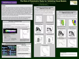
The Role of Polarimetric Radar for Validating Cloud Models Robert Cifelli 1 , Timothy Lang 1 , Stephen Nesbitt 1 , S.A. Rutledge 1 S. Lang 2 , and W.K. Tao 2 1 Colorado State University 2 NASA Goddard Space Flight Center. Observation and GCE Model Comparisons: TRMM-LBA 26 January 1999.

E N D
The Role of Polarimetric Radar for Validating Cloud Models Robert Cifelli1, Timothy Lang1, Stephen Nesbitt1, S.A. Rutledge1 S. Lang2, and W.K. Tao2 1 Colorado State University 2 NASA Goddard Space Flight Center Observation and GCE Model Comparisons: TRMM-LBA 26 January 1999 Observation and GCE Model Comparisons: TRMM-LBA 23 January 1999 The 26 January event represents an example of “easterly” convection sampled during TRMM-LBA. This system propagated into the TRMM-LBA domain as an intense squall line. 3-D model simulations were performed using a cold pool initialization and 3-ice microphysics (Rutledge and Hobbs [RH] a modified version without dry graupel growth [DRY0],and reduced collection of cloud ice by snow [DRY0SN]). The 23 February event represents an example of “westerly” convection sampled during TRMM-LBA. This system initiated as a response to diurnal forcing with no preferred initial orientation to the convection. 3-D model simulations were performed using diurnally varying fluxes measured at two locations (Abracos Hill and Ji Parana airport), 3-ice microphysics (Rutledge and Hobbs [RH] and a modified version without dry graupel growth [ACC0]), and horizontal domain resolutions varing from 0.25-1km. A Physically-Based Polarimetric Rainfall Algorithm Advantages of Polarimetric Radar • Methodology • Remove ground clutter and spurious echos using thresholds on HV and DP following Ryzhkov and Zrnic (1998) • Estimate rainfall using polarimetric optimization procedure (see flow chart) and Z-R methodology • A hydrometeor identification (HID) routine following Chandrasekar et al. (1993) is used to identify precipitation ice in the interpolated radar data • Interpolate the rainfall and HID results to a Cartesian grid • Several polarimtric estimators are commonly used in combination for hydrometeor identification (HID), drop size distribution (DSD) retrievals and rainfall estimation: • ZH - Horizontal reflectivity (same as measured with non-polarimetric radars like NEXRAD) • ZDR - Differential reflectivity is the ratio of horizontal to vertical power returns and is a good measure of drop shape and the resulting drop size • KDP - Specific differential phase is a measure of the phase lag between the horizontal and vertical polarization channels over a specified range. Because KDP is relatively insensitive to ice and the form of the DSD, it is a good estimator of rain rate. It is also immune to errors in radar calibration and partial beam blocking. Imposed diurnal surface fluxes in the Feb 23 simulations based on surface flux data collected from ABRACOS Hill and Ji Parana Simulated and observed convective fractions for Feb 23 using the Steiner technique Radar Reflectivity and storm relative winds at 4 km AGL. Simulated radar reflectivity at 225 min at 4.08 km using RH microphysics. SPOL Radar Observations GCE: 1 km resolution SPOL Radar Observations GCE: 1 km resolution Polarimetric Algorithm Equations R(KDP,ZDR) = 87.6 * (KDP)0.934 *10(0.1*-1.59*ZDR) mm hr-1 R(ZH,ZDR) = 6.70 x 10⁻³ * (ZH)0.927 * 10(0.1*-3.433*ZDR) mm hr-1 R(KDP) = 50.7 * (KDP)0.85 mmhr-1 R(ZH) = 0.0033 * (ZH)0.7143 mm hr-1 Radar Reflectivity Radar Reflectivity Radar Reflectivity Radar Reflectivity Convective Fraction Rain Rate Histogram Dual-Doppler Radar Observations GCE: 1 km resolution Rain Rate Hydrometeor Identification Rainfall Estimation Vertical Air Motion Vertical Air Motion Rain Rate Histogram Cross section of CSU-CHILL radar data through the 29 June 2000 supercell collected during STEPS-2000. Hydrometeor types are indicated by color shading. Magenta dots represent lightning sources identified with LMA network data. DSD Characteristics Comparison of accumulated rainfall using the CHILL polarimetric rainfall estimator (top) vs the standard NEXRAD Z-R estimator (bottom). The data was collected by the CSU-CHILL radar over the Denver metro area on June 19, 2003. Composite ZDR and D0 as a function of radar reflectivity for the Easterly and Westerly convective regimes sampled during TRMM-LBA. Rain Rate Summary Polarimetric radar retrieval techniques have advanced considerably over the last decade or so. In addition to sampling the kinematic and vertical structure of precipitation features (using the traditional radar reflectivity parameter), polarimetric radars can take advantage of the phase lag and relative signal strength at horizontal and vertical polarization to provide useful information on drop size characteristics, rain-ice fraction, and hydrometeor species within the radar pulse volume. Moreover, because polarimetric radars sample additional information about the drop size distribution compared to conventional non-polarimetric radars (e.g., NEXRAD), accurate rainmaps can be constructed that do not rely on the large uncertainty associated with Z-R relationships.Therefore, polarimetric radar provides a useful validation tool for numerical model simulations of many cloud microphysical processes. This poster provides a brief overview of polarimetric radar measurements and microphysical retrievals. Moreover, we show comparisons between polarimetric radar and the Goddard Cumulus Ensemble (GCE) model for several events observed during TRMM-LBA. Acknowledgements This work is supported by the NASA TRMM and GPM Programs.