Download
1 / 4
40 likes | 166 Vues
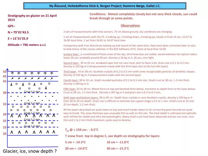
Ny-Ålesund, Holtedalfonna Stick 6, Bergen Project; Hammre Børge, Gallet J.C. Conditions: Almost completely cloudy but not very thick clouds, sun could break through at some points. Stratigraphy on glacier on 21 April 2013 GPS : N = 79˚01’43.5 E = 13˚31’25.9 Altitude = 766 meters a.s.l.

E N D
Ny-Ålesund, Holtedalfonna Stick 6, Bergen Project; Hammre Børge, Gallet J.C. Conditions: Almost completely cloudy but not very thick clouds, sun could break through at some points. Stratigraphy on glacier on 21 April 2013 GPS : N = 79˚01’43.5 E = 13˚31’25.9 Altitude = 766 meters a.s.l. Observations 2 sets of measurements with trios sensors, 75 cm above ground, sky conditions are changing 1 set of measurements with the FS, 3 looking up, 3 looking down, 3 looking up, clouds in front of sun, 15:57 to 16:00 local time, 2 set from 16:05 to 16:07 local time Comparison with trios directly by looking up and record at the same time. Data have been corrected later on due to bad choice of the cosine collector in the RS3 Software of FS. Done at local time 16:09 Surface layer : is constituted of fresh snow of the day, third branches are visible, would estimate the optical radius lower 50 µm, probably around 30 µm. Density is 26 Kg.m-3, 26 yes, very light. Second layer: 45 to 43 cm: windpack layer but not very hard, start to facet a bit. Grain size is 0.1 to 0.2 mm. Density is 232 Kg.m-3 (measurement mixed with the third layer due to the too thin layer). Third layer: 43 to 38 cm, facetted crystals of 0.2 to 0.3 mm with some recognizable particles of dendritic shapes . Density of 232 kg.m-3 (measurement made with the second layer) Fourth layer: 38 to 32 cm. Small rounded particles of 0.2 to 0.3 mm size. Small crust at 38 cm, 1-2 mm thick. Density is 304 kg.m-3. Fifth layer: 32 to 28 cm. Mixed form on top and facetted form below, transition to depth hoar to the layer below. Crust at 28 cm, 1-2 mm thick. Density is 307 kg.m-3 and grain size is 0.3 to 0.5 mm. Sixth layer and bottom layers: 28 to 20 cm. Depth Hoar crystals or very facetted crystals, density is 344 kg.m-3 from 28 to 20 cm depth. Grain size is difficult to estimate but a good range is 0.5 to 1 mm. Small crust at 25 and 23 cm depth, 1-2 mm thick. All the layers described are quite loose on top and much harder down to 32 cm but the grain bounds are quite easy to break. The snow thickness was unusually thin as well on this site. The total depth is unknown but optically semi infinite for visible and infra red wavelengths. Many small crust have been observed and are sun crust, very thin and 1 to 2 mm thick maximum, quite easy to destroy. 50 45 43 Crust 1-2 mm 38 Crust 1-2 mm 32 Crust 1-2 mm 28 Crust 1-2 mm 25 Crust 1-2 mm 23 Tair@ + 150 cm : - 9.5°C T snow from top in degree C, see depth on stratigraphy for layers: 5 cm = -10.3°C 10 cm = -11.8°C 20 cm = -14.0°C 30 cm = -15.2°C 20 Glacier, ice, snow depth ?
HTD Stick 6 på 21 April 2013, sot prøvetaking av Børge hammre