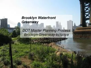
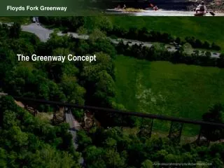
The Greenway Concept
The Greenway Concept. Aerial oblique photography by Michael Mason Frank. Goals. Provide a wide range of recreational activities appropriate to the place. Provide a trail system , including the Metro Loop Trail, that allows access throughout the greenway for a variety of trail users.

The Greenway Concept
E N D
Presentation Transcript
The Greenway Concept Aerial oblique photography by Michael Mason Frank
Goals • Provide a wide range of recreational activities appropriate to the place. • Provide a trail system, including the Metro Loop Trail, that allows access throughout the greenway for a variety of trail users. • Provide vehicular access and parking. • Preserve, enhance and restore key environmental resources. • Preserve, enhance and restore key cultural resources. • Provide operations facilities for the park.
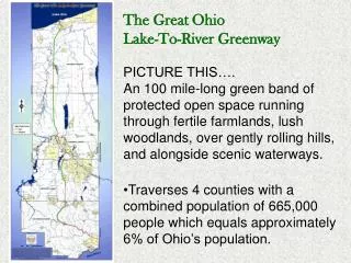
Greenway Concept: A 21st Century Life Support System Floyds Fork Greenway will be a model of 21st century Green Infrastructure The Greenway will: • be a public open space system that is a combination of parks, trails, and conservation lands. • provide a wide range of active and passive recreation, education, cultural arts activities. • preserve and enhance cultural and environmental resources. • be a productive landscape that reflects the longstanding agricultural heritage of the local landscape. • serve as a model for sustainable design and management practices for future neighborhood development. • define the edge between public open space and surrounding land uses.
Master Planning Approach: After careful evaluation of public interest and the existing conditions, the following strategy is proposed to develop a greenway master plan, secure regulatory approval, and comply with guidelines for federal expenditures: Create a single, negotiated concept for the park and water trail components of the greenway Explore alternative routes for the metro loop trail
One Greenway, Two Experiences Northern Greenway Connected to the communities, higher level of active recreation and cultural activities Southern Greenway Less developed, more rustic, more nature-based recreation
Park Concept • The park experience will change along the length of the greenway, to accommodate existing conditions and different recreational uses and to provide variety.
Metro Loop Trail • Cornerstone 2020 plan calls for a continuous 100 mile loop trail around Jefferson County connecting the three major landscape features of the county: Ohio River, Jefferson Memorial Forest, and Floyds Fork • To achieve this connection in the Floyds Fork Greenway, the trail will be built on a combination of public land and easements on private land. • Trail will encounter four categories of ownership: • Existing public parkland (such as Miles Park owned by Metro Parks) • Private land that is accessible to the public • Other municipal services (such as MSD and the Fire Training Center) • Easements on private, non profit land ( such as on Future Fund, Inc. lands)
Conceptual Trail Alternatives • Alignments generally reflect the general intent to develop this segment of the 100-mile Metro Loop Trail, and to provide access to public park land in the greenway. • Alignments are based on inventory and analysis of natural and cultural features. • Alignments are subject to change based on further feasibility analysis, development of recreational program, and the avoidance, minimization and mitigation of impacts to the natural and cultural resources of the greenway.
Metro Loop Trail Alternatives 1 Two Conditions Occur: • Internal Choices on public land ( e.g., lowland route versus upland route) • External Choices when parkland or publicly-accessible land is separated by private land 2
Water: The Key Resource • Floyds Fork and its tributaries are the core of the attraction and visitor experience in the Greenway
Floodways and Floodplains The floodway and floodplain limit the locations for facility development to avoid property damage The floodway and floodplain are opportunities for habitat preservation and restoration.
Slopes Define the Corridor • Steep slopes form a clear edge to the floodplain bottomlands. • The slopes present a constraint to facility development • The slopes provide an opportunity for habitat conservation and scenic vista preservation.
Public Road Access • Existing public roads will provide park access • Park access roads are shown as short roads connecting to parking areas • A comprehensive park access plan is being developed in concert with KYTC and KIPDA’s ongoing and proposed road improvement program • 21st Century Parks is also studying how best to integrate the Greenway road system with proposed public road improvements
Location and Ownership Public Parkland or Publicly-accessible Private Land
Water Trail • The Floyds Fork Water Trail will reach from Shelbyville Road to Bardstown Road and, eventually, beyond to the Salt River • Public access points are provided along the length on public property only • Access points are still under study
Metro Loop Trail20+ mile segment of 100 mile loop The location of all improvements is conceptual and subject to change based on public input, engineering feasibility, resource impacts, and recreational program development.
Secondary TrailsProvide smaller loop routes and specialized trails within parks The location of all improvements is conceptual and subject to change based on public input, engineering feasibility, resource impacts, and recreational program development.
Trail Access Features The location of all improvements is conceptual and subject to change based on public input, engineering feasibility, resource impacts, and recreational program development.
Metro Loop Trail and Alternatives Trail alignment is conceptual and subject to change based on further study, feasibility and detailed resource impact analysis Alignment is based on: • preliminary environmental inventory • preliminary cultural resource inventory • land ownership • potential recreational program
North Reach Central Reach South Reach Enlargement Plans • Concept plans were done for each park parcel to explore a range of actions and programs. • A base level of environmental enhancement actions was considered, including riparian and property buffers, reforestation, woodland buffers, and stream restoration, based on inventory and analysis. • The following slides show how this process was applied to one parcel.