Download
1 / 4
40 likes | 163 Vues
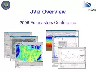
JViz is a sophisticated Java-based application designed for visualizing 4D weather data. Featuring an intuitive and interactive user interface, it allows users to access and configure various data sets tailored to specific ranges. Users can access JViz through display nodes (VMET) and WebStart. The application integrates diverse datasets, including RTFDDA model data, GOES satellite data, NAM data, and radar data. JViz provides various visualization products, such as 2D maps, vertical cross-sections, SkewT plots, time-series plots, meteograms, and tables to enhance meteorological data analysis.

E N D
What is JViz? • 2-D display (Java) application for 4dwx. • Intuitive, interactive user-interface. • Configured for each range. • Access via display node (vmet) and webstart.
JViz’s Data Sets RTFDDA Model Data. GOES Satellite Data. NAM data. Radar data (1 chosen for each range). SAMS, Mesowest and WMO metars, Lightning. Soundings. Profilers. GIS-like data.
JViz’s Viz Products 2D maps. Vertical cross-sections. SkewT plots. Time-series plots. Time-height (meteogram) plots. Tables.