Download
1 / 7
70 likes | 89 Vues
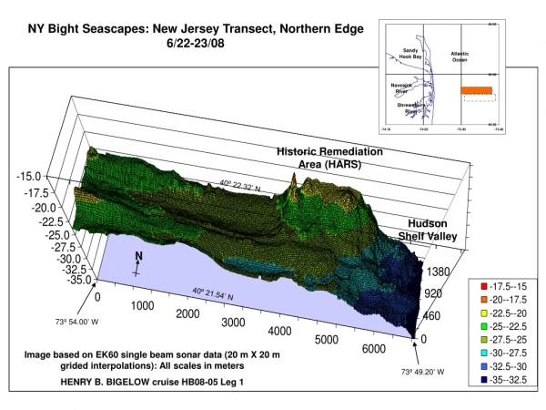
NY Bight Seascapes: New Jersey Transect, Northern Edge 6/22-23/08. Historic Remediation Area (HARS). 40 º 22.32’ N. Hudson Shelf Valley. 40 º 21.54’ N. 73 º 54.00’ W.

E N D
NY Bight Seascapes: New Jersey Transect, Northern Edge 6/22-23/08 Historic Remediation Area (HARS) 40º 22.32’ N Hudson Shelf Valley 40º 21.54’ N 73º 54.00’ W Image based on EK60 single beam sonar data (20 m X 20 m grided interpolations): All scales in meters HENRY B. BIGELOW cruise HB08-05 Leg 1 73º 49.20’ W
NY Bight Seascapes: New Jersey Transect, Central Area 6/23-24/08 Hudson Shelf Valley N Image based on EK60 single beam sonar data (20 m X 20 m grided interpolations): All scales in meters HENRY B. BIGELOW cruise HB08-05 Leg 1
NY Bight Seascapes: New Jersey Transect, 6/22-24/08 Image based on EK60 single beam sonar data (20 m X 20 m grided interpolations): All scales in meters HENRY B. BIGELOW cruise HB08-05 Leg 1
NY Bight Seascapes: Long Island Transect 6/20-21/08 Image based on EK60 single beam sonar data (20 m X 20 m grided interpolations): All scales in meters HENRY B. BIGELOW cruise HB08-05 Leg 1
Maryland Coastal Reefs: Lobster Hole 6/28/08 Image based on EK60 single beam sonar data (20 m X 20 m grided interpolations): All scales in meters HENRY B. BIGELOW cruise HB08-05 Leg 1
Maryland Coastal Reefs: Inshore SE Ridge 6/27-29/08 Image based on EK60 single beam sonar data (20 m X 20 m grided interpolations): All scales in meters HENRY B. BIGELOW cruise HB08-05 Leg 1
Maryland Coastal Reefs: Offshore Third Lump 6/29-7/2/08 Image based on EK60 single beam sonar data (20 m X 20 m grided interpolations): All scales in meters HENRY B. BIGELOW cruise HB08-05 Leg 1