08/28/2008
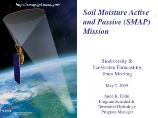
http://smap.jpl.nasa.gov/. Soil Moisture Active and Passive (SMAP) Mission Biodiversity & Ecosystem Forecasting Team Meeting May 7, 2009 Jared K. Entin Program Scientist & Terrestrial Hydrology Program Manager. National Aeronautics and Space Administration. SMAP- 1. 08/28/2008.

08/28/2008
E N D
Presentation Transcript
http://smap.jpl.nasa.gov/ Soil Moisture Active and Passive (SMAP) Mission Biodiversity & Ecosystem Forecasting Team Meeting May 7, 2009 Jared K. Entin Program Scientist & Terrestrial Hydrology Program Manager National Aeronautics and Space Administration SMAP-1 08/28/2008 JPL/Caltech proprietary. Not for public release or redistribution. For planning and discussion purposes only.
Soil Moisture Freeze/ Thaw Radiation Mission Science Objectives • Global mapping ofSoil Moisture and Freeze/Thaw state to: • Understand processes that link the terrestrial water, energy & carbon cycles • Estimate global water and energy fluxes at the land surface • Quantify net carbon flux in boreal landscapes • Enhance weather and climate forecast skill • Develop improved flood prediction and drought monitoring capability Primary Controls on Land Evaporation and Biosphere Primary Productivity
SMAP Science and Applications SMAP in Decadal Survey “…the SMAP mission is ready for “fast-track” towards launch as early as 2012, when there are few scheduled Earth missions. The readiness of the SMAP mission also enables gap-filling observations to meet key NPOESS community needs (soil moisture is “Key Parameter,” see 4.1.6.1.6 in IORD-II Document).” SMAP is one of four missions recommended by the NRC Earth Science Decadal Survey for launch in the 2010-2013 time frame
SMAP Mission Concept • Mission Development Schedule • Phase A start: September 2008 • SRR/MDR: February 2009 • PDR: December 2009 • CDR: December 2010 • SIR: October 2011 • Instrument Delivery April 2012 • LRD: March 2013 • Mission operations duration: 3 years • Orbit: • Sun-synchronous, 6 am/pm orbit • 670 km altitude • Instruments: • L-band (1.26 GHz) radar • High resolution, moderate accuracy soil moisture • Freeze/thaw state detection • SAR mode: 3 km resolution • Real-aperture mode: 30 x 6 km resolution • L-band (1.4 GHz) radiometer • Moderate resolution, high accuracy soil moisture • 40 km resolution • Shared instrument antenna • 6-m diameter deployable mesh antenna • Conical scan at 14.6 rpm • Constant incidence angle: 40 degrees • 1000 km-wide swath • Swath and orbit enable 2-3 day revisit
SMAP Data Will Enable Reliable Estimates of Changes to Future Water Availability Changes to water availability is a critical practical impact of global warming on society. How will global change affect water supply and food production? Intergovernmental Panel on Climate Change (IPCC) climate model projections by region: Change in Temperature [C] Change in Soil Moisture [%] 6 3 5 Models disagree on whether there will be MORE or LESS water compared to today 4 2 3 Models agree on direction of temperature change 2 1 1 0 0 -1 -2 -1 -3 -4 -2 -5 -6 -3 Sahel Sahel SE Asia SE Asia S Europe S Europe Australia Australia N America N America Without SMAP data we cannot tell which hydrology models are accurate. With SMAP data we will be able to make reliable determination of future changes in available water. Li et al., (2007): Evaluation of IPCC AR4 soil moisture simulations for the second half of the twentieth century, Journal of Geophysical Research, 112. SMAP-5
Campbell Yolo Clay Field Experiment Site, California Soil Evaporation Normalized by Potential Evaporation Surface Soil Moisture [% Volume] Measured by L-Band Radiometer “Link Terrestrial Water, Energy and Carbon Cycle Processes” Water and Energy Cycle Carbon Cycle Soil Moisture Controls the Rate of Continental Water and Cycles Landscape Freeze/Thaw Dynamics Drive Boreal Carbon Balance [The Missing Carbon Sink Problem]. Do Climate Models Correctly Represent the Landsurface Control on Water and Energy Fluxes? What Are the Regional Water Cycle Impacts of Climate Variability? Are Northern Land Masses Sources or Sinks for Atmospheric Carbon?
Growing season onset from atmospheric CO2 samples (difference from multi-year mean, days) Thaw day difference from multi-year mean (days) Primary thaw day (DOY) “Quantify Net Carbon Flux in Boreal Landscapes” SMAP will complement atmospheric CO2 monitoring by providing important information on the land surface processes that control land-atmosphere carbon source/sink dynamics. It will provide more than 8-fold increase in spatial resolution over existing spaceborne sensors. Mean growing season onset for 1988 – 2002 derived from coarse resolution SSM/I data Annual comparison of pan-Arctic thaw date and high latitude growing season onset inferred from atmospheric CO2 samples, 1988 – 2001 McDonald et al. (2004): Variability in springtime thaw in the terrestrial high latitudes: Monitoring a major control on the biospheric assimilation of atmospheric CO2 with spaceborne microwave remote sensing. Earth Interactions 8(20), 1-23.
“Extend Weather and Climate Forecast Skill” Predictability of seasonal climate is dependent on boundary conditions such as sea surface temperature (SST) and soil moisture – Soil moisture is particularly important over continental interiors. 24-Hours Ahead High-Resolution Atmospheric Model Forecasts Prediction driven by SST Difference in Summer Rainfall: 1993 (flood) minus 1988 (drought) years Without Realistic Soil Moisture Observations Prediction driven by SST and soil moisture Buffalo Creek Basin Observed Rainfall 0000Z to 0400Z 13/7/96 (Chen et al., 2001) (Schubert et al., 2002) With Realistic Soil Moisture High resolution soil moisture data will improve numerical weather prediction (NWP) over continents by accurately initializing land surface states -5 0 +5 Rainfall Difference [mm/day]
“Develop Improved Flood and Drought Prediction Capability” “…delivery of flash-flood guidance to weather forecast offices are centrally dependent on the availability of soil moisture estimates and observations.” “SMAP will provide realistic and reliable soil moisture observations that will potentially open a new era in drought monitoring and decision-support.” Decadal Survey: Operational Drought Indices Produced by NOAA and National Drought Mitigation Center (NDMC) NOAA National Weather Service Operational Flash Flood Guidance (FFG) • Current Status: Indirect soil moisture indices are based on rainfall and air temperature • (by county or ~30 km) • SMAP Capability: Direct soil moisture measurements – global, 3-day, 10 km resolution
Applications and User Engagement • By providing direct measurements of soil moisture and freeze/thaw state, SMAP will enable a variety of societal benefits: • Near-term SMAP applications outreach will be focused on: • 1. Developing a community of end-users, stakeholders, and decision makers that understand SMAP capabilities and are interested in using SMAP products in their application (SMAP Community of Practice). • 2. Developing an assessment of current application benefits / requirements and needs for • SMAP products (survey). • 3. Identifying a handful of “early adopters” who will partner to optimize their use of • SMAP products, possibly even before launch as part of the extended OSSE activities • (“targeted partners”). • 4. Providing information about SMAP to the broad user community Droughts Floods/Landslides Agriculture Weather/Climate Human Health
DoD Relevance • US Army Space and Missile Defense Command, • Army Research Laboratory, G-2, Corps of Engineers, • and Marine Corps will use experiment data to validate • and improve tools to evaluate threat and friendly mobility • 1.Cross Country Mobility (CCM) • 2. Tri-Service Integrated Weather Effects Decision Aid (IWEDA) • 3. Battlespace Terrain Reasoning / Awareness (BTRA) • 4. Opportune Landing System (OLS) • 5. Integrated air and space operations support • Air Force Weather Agency will use experiment data to • Initialize Numerical Weather Prediction (NWP) model for aviation weather, severe weather and fog forecasts • Input into Dust Transport Model (DTM) Naval Ice Center will use experiment data for high resolution mapping of marine and littoral ice cover and ice characteristics • Documentation • 1. AFSPC weather information key EDR • 2. JROC IORD-II EDR: KPP 4.1.6.1.6(Category 1-A)
Day SMOS SMAPRadar-Radiometer ClimateApplications Aquarius Weather Applications Week Resolved Temporal Scales Evolution of L-Band Sensing CarbonCycle Applications Radiometer Radar Month ALOSSAR 100 km 10 km 1 km Resolved Spatial Scales SMAP Mission Uniqueness
Science L1 Requirements (1)North of 45°N latitude Baseline Mission Duration Requirement is 3 Years (Decadal Survey)
Science Products Global Mapping L-Band Radar and Radiometer High-Resolution and Frequent-Revisit Science Data Observations+Model Value Added Science Data
Science Definition Team (SDT) Dara Entekhabi (MIT) – Sci Team Lead Eni Njoku (JPL) – Proj Sci Peggy O’Neill (GSFC) – Dep Proj Sci Wade Crow (USDA ARS) SM Assimilation Tom Jackson (USDA ARS) Cal/Val & Algorithm Joel Johnson (Ohio St. U) RFI & SM Algorithm John Kimball (U-Mt) Frz/thw Alg. & Carbon Cycle Sci Randy Koster (GSFC) Wea/Clim model initialization Kyle McDonald (JPL) Frz/thw Alg. & Carbon Cycle Sci Mahta Moghaddam (U Mich) Algorithms & Carbon Cycle Sci Susan Moran (USDA ARS) Applications (Flood/Drought) Rolf Reichle (GSFC) SM Assim. & W/C initialization J. C. Shi (UCSB) SM Retrieval Algorithm Leung Tsang (U Wash) SM Retrieval Algorithm Jacob van Zyl (JPL) SM Retrieval Algorithm
Accurately Constraining Root-Zone Soil Moisture Estimates using Remotely-Sensed Surface Soil Moisture Observations • Red areas indicate regions where the assimilation of AMSR-E surface soil moisture retrievals correct the RMSE impact of TRMM rainfall errors on modeled root-zone soil moisture predictions. • Given potentially large errors in satellite-based rainfall products, results suggest a role for SMAP soil moisture retrievals in global ecologic applications requiring root-zone soil moisture information. Research funded by the NASA Applied Sciences Program (W. Crow, PI). Figures taken from Bolten, Crow, Zhan, Jackson and Reynolds, “Evaluating the utility of remotely-sensed soil moisture for agricultural drought applications,” IEEE Selected Topics is Applied Remote Sensing, in revision, 2009.
Project Status • Project entered Phase A on September 24, 2008 • Held SMAP Field Experiment in Oct, 2008 to assess Radio Frequency Interference (RFI) at L-band and test mitigation strategies • Science Definition Team was selected in Oct 2008 – held 1st meeting in Nov. • 1st meetings held in Nov’08, Mar’09, and in late July’09 • Project is making good progress on key Phase A trade studies and requirements and system interface definition as appropriate for Mission Design Review • Project submitted Level one requirements to ESM and HQ • Concluded major flight system architecture trades • Initiated dynamics team, developed initial flight system dynamics and pointing model • SDT completed an RFI risk assessment and has formally recommended to incorporate additional risk mitigation features. SMAP-17
Community Involvement • SMAP has a public website • SMAP science leadership have engaged operational applications communities • NOAA NCEP/NWP & NWS Office of Hydrology Development, ECMWF, AFWA have expressed specific and strong interest in using SMAP data • NOAA has established a SMAP working team & high-priority study topics • SMAP held an Open Meeting at IGARSS, July ‘08; 50 people attended • SMAP was well represented at the October Hydrology Workshop • SMAP SDT Working Groups are established Applications, RFI, Algorithms, Cal/Val; informal meetings were held at Fall AGU (Dec’08) • Planning future SMAP-related workshops, e.g., on Cal/Val & Algorithms (June 2009). SMAP-18
Issues – Future Plans • SMAP has no technology readiness issues • SMAP Science Project plans • Algorithm testbed • Data assimilation framework for level 4s & operational requirements • Using SMOS data as prototype for algorithm testing • Algorithm refinement through field campaigns. • SMAP is one of the first decadal survey missions to be implemented. Some of its issues can be raised to be considered at programmatic level • Data latency requirements for science versus operational community desire • Ground network capability to handle data volume • Desire for common infrastructure Connected SMAP-19
Hi-Res LSM Input Parameters Hi-Res LSM Input Parameters Hi-Res LSM Input Parameters Hi-Res LSM Input Parameters Instrument Noise (Radar/Radiometer) Instrument Noise (Radar/Radiometer) Instrument Noise (Radar/Radiometer) Instrument Noise (Radar/Radiometer) Surface Temp Surface Temp Surface Temp Surface Temp Soil Texture Soil Texture Soil Texture Soil Texture Orbital/ instrument Sampling Orbital/ instrument Sampling Orbital/ instrument Sampling Orbital/ instrument Sampling Forward Models (Radar/Radiometer) Forward Models (Radar/Radiometer) Forward Models (Radar/Radiometer) Forward Models (Radar/Radiometer) TB TB TB TB σo σo σo σo Vegetation Vegetation Vegetation Vegetation : : : : : : : : Retrieved Soil Moisture Retrieved Soil Moisture Retrieved Soil Moisture Retrieved Soil Moisture “Truth” Soil Moisture “Truth” Soil Moisture “Truth” Soil Moisture “Truth” Soil Moisture Error Analysis Error Analysis Error Analysis Error Analysis Inverse Models (Radar/Radiometer) Inverse Models (Radar/Radiometer) Inverse Models (Radar/Radiometer) Inverse Models (Radar/Radiometer) Algorithm Testbed Will help evaluate the relative merits of different microwave models, retrieval algorithms, and ancillary data for meeting SMAP’s soil moisture and freeze/thaw science objectives, based on a common set of input and processing conditions. • The SMAP Algorithm Testbed is currently under development and will be used to: • Evaluate the relative merits of different microwave models, retrieval algorithms, and ancillary data for meeting SMAP’s soil moisture and freeze/thaw science objectives, based on a common set of input and processing conditions. • Provide a system that can be used to test the integrated suite of SMAP science product algorithms as a prototype for the SMAP Science Data Processing System (SDS). • The Testbed is based on the Observing System Simulation Experiment (OSSE) developed during the Hydros Risk-Reduction Phase.
Applications and User Engagement • Near-term SMAP applications outreach will be focused on: • 1. Develop an assessment of current application benefits / requirements for SMAP products (The Survey). • 2. Develop a community of end-users that understand SMAP capabilities and are interested in using SMAP • products in their application (SMAP Community of Practice). • 3. Target partners who can work with SMAP project during pre-launch period. Possibly use the • SMAP Algorithm Test-Bed for assessment of impact on their applications. • (Targeted Partners): - NWP (NCEP, ECMWF, AFWA, Met Canada) • - Operational Hydrology (NWS HRL) • - Drought NIDS • - DoD (ERDC, AFWA) • 4. Provide information about SMAP to the Broad User Community (Web page, brochures, papers) • 5. Develop New User communities: • - Ecological services - Inundation (biogeochemical cycles and flood) • - Sea-ice - Hurricane tracking • - NWP ocean surface high winds - NPOESS gap-fill and MIS/VIIRS algorithm development
Thank You http://smap.jpl.nasa.gov Email: Jared.K.Entin@nasa.gov