Download
1 / 1
10 likes | 165 Vues
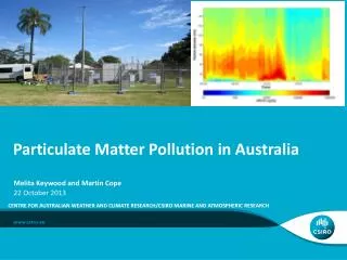
2006 GOES-R User’s Conference 1-3 May 2006. Estimates of Biomass Burning Particulate Matter (PM2.5) Emissions from the GOES Imager. Xiaoyang Zhang 1,2 , Shobha Kondragunta 1 , Chris Schmidt 3

E N D
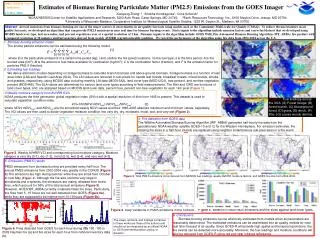
2006 GOES-R User’s Conference 1-3 May 2006 Estimates of Biomass Burning Particulate Matter (PM2.5) Emissions from the GOES Imager Xiaoyang Zhang1,2 , Shobha Kondragunta1, Chris Schmidt3 1NOAA/NESDIS/Center for Satellite Applications and Research, 5200 Auth Road, Camp Springs, MD 20746; 2Earth Resources Technology, Inc., 8106 Stayton Drive, Jessup, MD 20794 3University of Wisconsin-Madison, Cooperative Institute for Meteorological Satellite Studies, 1225 W. Dayton St., Madison, WI 53706 Abstract-Aerosol emissions from biomass burning are one of the major sources of uncertainties in air quality forecasts using models such as the Community Multi-scale Air Quality (CMAQ). To reduce the uncertainties in air quality forecasts, we developed an algorithm that can provide PM2.5 emissions in near real time for biomass burning events. Static inputs to the algorithm include emission factors and a new fuel dataset that we developed using MODIS land cover type, leaf area index, and percent vegetation cover at a spatial resolution of 1 km. Dynamic inputs to the algorithm include GOES Wild_Fire Automated Biomass Burning Algorithm (WF_ABBA) fire product with a temporal resolution of 30 minutes and fuel moisture derived from weekly AVHRR vegetation health condition. We tested the performance of the algorithm using fire data from 2002-2004 across the U.S. 1. Biomass burning emission model The smoke particle emissions can be estimated using the following model: (1) where E is the particulate emissions in a certain time period (kg); i and j define the fire (pixel) locations; l is the fuel type; k is the time period; A is the burned area (km2); M is the amount of fuel mass available for combustion (kg/km2); C is the combustion factor (fraction),and F is the emission factor for particles PM2.5 (fraction). 2. Estimating fuel loadings We derive allometric models depending on foliage biomass to calculate branch biomass and above ground biomass. Foliage biomass is a function of leaf area index (LAI) and Specific Leaf Area (SLA). The LAI values are retrieved in sub-pixels for needle leaf forests, broadleaf forests, mixed forests, shrubs, and grasses, respectively, using MODIS data including monthly LAI data (MOD15A2), land cover type (MOD12Q1), tree percent, and nontree-vegetation percent (MOD44B). The SLA values are determined for various land cover types according to field measurements. The litter and CWD are functions of land cover types, and are assigned based on MODIS land cover data, percent tree, percent non-tree vegetation for each 1km pixel (Figure 1). 3.Weekly moisture category from AVHRR GVIx NOAA produces the third generation global vegetation index (GVIx) with a spatial resolution of 4km from 1985 to present. This dataset is used to calculate vegetation condition index. VCI=100(NDVI-NDVImin)/(NDVImax-NDVImin) (2) where NDVI, NDVImax, and NDVImin are the smoothed weekly NDVI values and their 1985-2005 absolute maximum and minimum values, separately. The VCI values are then used to divide vegetation moisture condition into very dry, dry, moderate, moist, wet, and very wet (Figure 2). Figure 1. Fuel loadings across the USA. (A) Forest foliage, (B) forest branch, (C) Aboveground forest, (D) grass, (E) shrub, (F) litter, (G) coarse woody detritus. 4. Fire detection from GOES data The Wildfire Automated Biomass Burning Algorithm (WF_ABBA) generates half-hourly fire data from the geostationary NOAA weather satellite GOES-10 and 12 for the Western Hemisphere. For emission estimates, the missing fire sizes in a half-hour interval are replaced using neighbor instantaneous sub-pixel sizes in a fire event. Figure 2. Weekly AVHRR VCI and corresponding fuel moisture category. Moisture category is very dry (0-1), dry (1-2), moist (2-3), wet (3-4), and very wet (4-5). 5. Emissions (PM2.5) results PM25 emissions from biomass burning are provided every half hour. The annual PM25 emissions from 2002-2004 vary greatly in the CONUS (Figure 3).The emissions are high during summer while they are small from October to next May (Figure 4). Although the fire size could be very large in shrublands and croplands, the emissions are mainly released from forest fires, which account for 56% of the total annual emissions (Figure 5). However, GOES WF_ABBA currently underestimates fire sizes. Particularly, the fires from 5 -15 hours are not well detected from GOES (Figure 6a), while they are supposed to be intense from 10-19 hours (Figure 6b). Figure 3. Total PM2.5 emissions (tons) derived from NESDIS fuel loadings, weekly AVHRR moisture factors, and GOES fire size from 2002-2004. b Figure 4. Daily variations in PM25 emissions in the CONUS. Figure 5. Variation in total PM25 emissions and fire sizes against land cover types. 6. Conclusions Biomass burning emissions can be effectively estimated from models when all parameters are reasonably determined. The estimated emissions can be assimilated into air quality models for near real time forecast of air quality. Since GOES-R will provide high spatial and temporal resolutions, the fire events can be detected more accurately. Moreover, the fuel loadings and moisture conditions will also be retrieved from GOES-R using red and near infrared reflectance. a The views, opinions, and findings contained in these works are these of the authors and should not be interpreted as an official NOAA or US Government position, policy, or decision. Figure 6. Fires detected from GOES for each hour during day 150 -180 in 2002 Hayman fire (a) and fire sizes for each hour from national inventory data (b).