Assemble, Summarize, and Review Historical Data
440 likes | 578 Vues
Assemble, Summarize, and Review Historical Data. Rationale. Before an evaluation can begin, the user must assemble all the various historical products and tools. This module is designed to put forth ideas on the products and tools that should be reviewed. Lesson Objectives.

Assemble, Summarize, and Review Historical Data
E N D
Presentation Transcript
Rationale Before an evaluation can begin, the user must assemble all the various historical products and tools. This module is designed to put forth ideas on the products and tools that should be reviewed
Lesson Objectives • Determine the various type of data that exist for the evaluation • Identify historical data to be assembled • Identify tools that are available • Identify data to be summarized
What information should be collected before proceeding with the MLRA evaluation? • Use the Chat room to begin a list
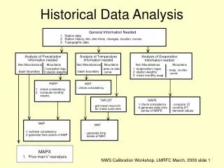
Data to be Assembled 610.03c • map unit descriptions • unpublished soil information • records documenting soil survey joining problems • interpretations • correlation records • field review reports • special investigation and laboratory data • pedon descriptions • transect data • tacit knowledge of those experienced in the area • notes of needed changes recorded in the office copy of the published soil
How Many Non-MLRA Soil Survey Areas Are In Your Area of Responsibility? MLRA 105 Crosses Into 35 Unique Non-MLRA Soil Survey Areas.
THE ORIGINAL SOIL SURVEY REPORTS WILL PROVIDE IMPORTANT INFORMATION
SOIL SURVEY REPORT • Map Unit Descriptions (Concept) • Composition • Dates of Field Work • Project Members • Georeferenced Series Descriptions (TUDS) • Dual Drainage Class? • 3SD Overrides? • Layer Thickness
Each MLRA should have copies of the correlation documents available in their area.
The Correlation Document Provides • Who (Who did the mapping) • When It Occurred • How many components (series and phases) • Notes to Accompany Series
The MLRA Explorer Snap Shot www.cei.psu.edu/mlra/
Things you learn using NASIS data The query pulled those components listed as a ”series”. MLRA 105 has some database work to complete
When Were the Series Established? Revised? • SERIES ESTABLISHED: Cass County, Illinois, 1939. • LOCATION ARENZVILLE WI+IA IL MN Established SeriesRev. AJK-HFG-TWN09/2006
Imagery 1939 • 1976 1985 2006
Multiple Year Imagery Sets Provide • Land Use Changes • Hydric Signatures • Flooding Signatures • Erosion? • Siltation? • Other?
What other types of data? • Farm and Ranch Plan Mapping • STATSGO • Geological Survey? • FEMA Maps? • Other?
Other Historical Resources • Maybe There’s a (Re)Tired Soil Scientist Around • University Cooperators • Masters Thesis or PhD Dissertations • What can the Field Office Staff Tell You? • Crop Consultants and Extension Agronomists • Foresters and Other Land Managers
Your GIS Workstation • Utilize digital layers of your MLRA • What Layers Are Available? • How Many SSA’s? • Distribution Maps
NCGC developed MLRA-SSO Geodatabases contain: • Detailed SSURGO Maps • 30m Digital Elevation Models • National Hydrography Layer • web map services NAIP (http://gis1.ftw.nrcs.usda.gov/arcgis/services)SSURGO (http://sdmdataaccess.nrcs.usda.gov/Spatial/SDM.wms?)
Distribution and Extent Maps Distribution map of fine-silty…typic hapludalfs in MLRA 105
Where is the Series Mapped? The Arenzville Series extends beyond MLRA 105. There is a gap in survey areas where Arenzville was not mapped.
Is there lab data available? Using Advanced Query by MLRA from Characterization web site Returns 265 pedons sampled in 105
Is there lab data available? Grab the NSSL access database by MO from lab sharepoint site
Suggested Activity • Develop an MLRA “Thunderbook” for your MLRA and list: • All manuscripts and their publication dates • Soil Survey Areas and correlation dates • Unique map unit names and total acreages • Unique components and their OSDs • Component acreage by survey area and totals • Correlation reports for the survey areas • NSSL samples
You are just getting started • One you’ve developed a good inventory, you’ll be able to examine: • individual components and phases • data map units • common resource areas • watersheds • dissimilar inclusions • landforms • properties • interpretations