Download
1 / 16
160 likes | 320 Vues
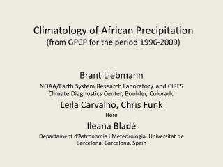
The Global Precipitation Climatology Project (GPCP) workshop, held from June 9 to 14, 2002, in Fairbanks, Alaska, aimed to enhance the understanding of solid precipitation in cold climates. Under the directorship of Arnold Gruber, the workshop focused on improving data accuracy for climate models by addressing the complexities of measuring solid precipitation. Despite advancements, direct measurements remain scarce, leading to biases in data. The collaboration among global data processing centers and observational networks is crucial for validation and refinement of precipitation models.

E N D
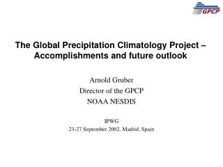
Global Precipitation Climatology Project(GPCP) Arnold Gruber Director of the GPCP WCRP Workshop on Detrermination of Solid Precipitation in Cold Climate Regions 9-14 June 2002, Fairbanks, Alaska
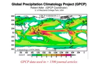
Global Precipitation Climatology Project • Organized in 1986 • Component of the Global Energy and Water Cycle Experiment (GEWEX) of WCRP • Objectives: • Improve understanding of seasonal to inter-annual and longer term variability of the global hydrological cycle • Determine the atmospheric heating needed for climate prediction models • Provide an observational data set for model validation and initialization and other hydrological applications
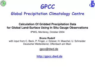
Global Tropics NOAA - National Weather Service Global Precipitation Climatology Project IR Component Data Processing Centres GMS Meteosat GOES NOAA JAPAN EUROPE UNITED STATES MW Component CAL/VAL Component Polar Satellite Precipitation Data Center Geostationary Satellite Precipitation Data Centre Surface Reference Data Centre emission scattering (EVAC - U.OK) (ocean) (land+ocean) Algorithm Intercompararison Program NASA-GSFC NOAA-NESDIS New Observations GPC Merge Development Centre Merged Global Analysis NASA - GSFC Station Observations (CLIMAT, SYNOP National Collections) Gauge - Only Analysis Global Precipitation Climatology Centre DWD - GERMANY
Remote Sensing Estimates used in GPCP • Infra –red • GOES • RR linearly related to fractional pixels Tcld<235K • Most effective for deep convective clouds, used only in 40N,S zone • High spatial and temporal resolution • false signatures, insensitive to warm top rain • TOVS • Regression between cloud parameters and rain gauges • Used in high latitudes where MW techniques are poor • Microwave (SSM/I) • Closely related to hydrometeors • Emission from cloud drops ( 29 GHz). Most effective over water surfaces ( Tsfc <<Tcld) • Scattering by ice particles over land over land ( 89, Tcld< Ta) • only ice clouds over land, low resolution, no estimate over snow and ice
IMPORTANT POINT Algorithms are designed for liquid precipitation Gauges Used to produce a gridded analysis, incorporates water equivalent of solid precipitation Final GPCP Precipitation Field satellite estimates adjusted to large scale gauge analysis ( water equivalent of solid precipitation incorporated in this stage) Satellite data merged with gauge analysis using inverse error variance weighting
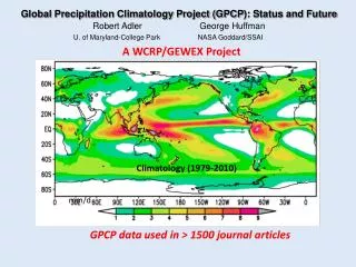
Global Precipitation Climatology Project • Current Products • Monthly mean 2.5°x2.5° latitude/longitude • Merged satellite and gauge, error estimates • Satellite components: microwave and infrared estimates, error estimates • Gauge analysis, error estimates • Intermediate analysis products, e.g., merged satellite estimates • Daily 1 x 1 degree, Pentad July 1987 and continuing -Version 1 1985 1990 1995 2000 1979 & Continuing- Version 2 , Pentad 1997 Daily 1x 1, deg
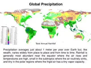
Global Precipitation Climatology Project Annual Mean Precipitation mm/day
1 x 1 degree, daily precipitation January 1, 1998 mm/day
Summary • Needs for solid precipitation • Atmosphere: Latent heat of fusion is important diabatic heat source • Surface: albedo affects land atmosphere energy exchange; important for surface hydrologic applications. e.g., floods, water resources, etc. • GPCP • No direct measure of solid precipitation rate – only water equivalent when adjusted to gauges • Can lead to bias where there are no gauges • Need validation and feedback on GPCP precipitation estimates over land areas • Techniques being developed to identify solid precipitation – need observed rates for calibration/validation
Global Precipitation Climatology Data • Monthly Mean 2.5 x 2.5 degree – 1979 and continuing • Pentad ( 5 day) 2.5 x 2.5 degree – 1979 and continuing • Daily, 1 x 1 degree - 1997 and continuing • Available On Line from World Data Center A at The National Climatic Data Center: • http://lwf.ncdc.noaa.gov/oa/wmo/wdcamet-ncdc.html
Potential of detecting falling snow over land using AMSU-B • Preliminary study (ongoing) using AMSU-B (89, 150, 183+1, 3, 7 GHz) • Great Plains U.S (flat, homogeneous) • Cases where no snow existed, active snowfall and remaining snowcover after precipitation event • Ancillary data: • NEXRAD composites • Synoptic weather reports/first order stations • Hourly precipitation amounts • QC of AMSU & surface reports to insure that proper surface and weather types have been classified
Preliminary Findings • Use of AMSU-B 150 and 176 GHz appears to be best set of channels • Single channel inadequate • More channels may not add much more information • Application to case studies seems promising, but • Need to consider false alarm rate • Need to determine global applicability • Need to determine sensitivity to snowrate, cloud physics, etc.
Algorithm Enter Rain Rate Algorithm Snow on Ground? NO YES Snow Index = 6.4 + 0.213*TB150-0.043*TB176 No Falling Snow Snow Index > 0.60? NO YES TB176 > TB180? NO YES Snow is Falling