Download
1 / 1
10 likes | 118 Vues
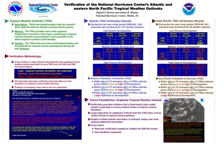
TWOAT TROPICAL WEATHER OUTLOOK NWS TPC/NATIONAL HURRICANE CENTER MIAMI FL 530 AM EDT TUE AUG 23 2007 FOR THE NORTH ATLANTIC...CARIBBEAN SEA AND THE GULF OF MEXICO... CLOUDINESS AND SHOWERS EXTEND FROM EASTERN CUBA AND HISPANIOLA ACROSS THE

E N D
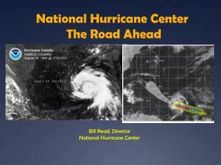
TWOAT TROPICAL WEATHER OUTLOOK NWS TPC/NATIONAL HURRICANE CENTER MIAMI FL 530 AM EDT TUE AUG 23 2007 FOR THE NORTH ATLANTIC...CARIBBEAN SEA AND THE GULF OF MEXICO... CLOUDINESS AND SHOWERS EXTEND FROM EASTERN CUBA AND HISPANIOLA ACROSS THE SOUTHEASTERN BAHAMAS AND THE TURKS AND CAICOS ISLANDS... AND INTO THE ATLANTIC FOR A FEW HUNDRED MILES. THIS ACTIVITY... WHICH IS POSSIBLY ASSOCIATED WITH THE REMNANTS OF TROPICAL DEPRESSION TEN...HAS BECOME MORE CONCENTRATED THIS MORNING NEAR THE SOUTHEASTERN BAHAMAS. ADDITIONAL DEVELOPMENT OF THIS SYSTEM IS POSSIBLE DURING THE NEXT DAY OR TWO AS IT MOVES WEST-NORTHWESTWARD AT ABOUT 10 MPH. AN AIR FORCE RESERVE HURRICANE HUNTER AIRCRAFT IS SCHEDULED TO INVESTIGATE THE SYSTEM THIS AFTERNOON...IF NECESSARY. ELSEWHERE... TROPICAL STORM FORMATION IS NOT EXPECTED THROUGH WEDNESDAY. THUNDERSTORM ACTIVITY HAS BECOME BETTER ORGANIZED IN ASSOCIATION WITH A LARGE TROPICAL WAVE LOCATED OVER THE EASTERN ATLANTIC OCEAN ABOUT 700 MILES WEST OF THE CAPE VERDE ISLANDS. THIS SYSTEM HAS THE POTENTIAL TO DEVELOP INTO A TROPICAL DEPRESSION DURING THE NEXT COUPLE OF DAYS AS IT MOVES WESTWARD OR WEST- NORTHWESTWARD AT 10 TO 15 MPH. CLOUDINESS AND SHOWERS ASSOCIATED WITH A TROPICAL WAVE ARE CURRENTLY OVER THE LESSER ANTILLES AND SPREADING TOWARD THE VIRGIN ISLANDS AND PUERTO RICO. UPPER LEVEL WINDS REMAIN UNFAVORABLE FOR DEVELOPMENT. FORECASTER XXXXX Medium High High Medium Low Verification of the National Hurricane Center’s Atlantic and eastern North Pacific Tropical Weather Outlooks Daniel P. Brown and Jamie R. Rhome National Hurricane Center, Miami, FL Tropical Weather Outlooks (TWO) Atlantic TWO Verification Results East Pacific TWO Verification Results During the two year study period (2005-06), 801 forecasts were produced for 88 weather systems. During the two year study period (2005-06), 1540 forecasts were produced for 147 weather systems. Description: TWOs text based products that are issued 4 times daily for both the Atlantic and East Pacific basins. Low Chance Development Low Chance Development Mission: The TWO provides users with a general assessment of activity in the tropics, pertaining to tropical cyclone formation by providing to users possible areas where tropical cyclones could develop. Content: The TWOs discuss areas of disturbed weather and the potential for tropical cyclone development during the next 48 hours. Medium Chance Development Medium Chance Development Verification Methodology A low, medium or high chance of development was assigned to each weather system described in every TWO from the 2005 and 2006 hurricane seasons. High Chance Development High Chance Development -Low- tropical cyclone formation not expected -Medium- some development possible -High- tropical depression (cyclone) could form Atlantic Probability of Detection (POD) D East Pacific Probability of Detection (POD) E F The forecasts were then verified by best-track data as to the formation of a tropical cyclone within 48 hours. Within 48 h of TC formation 74% of TWOs indicate some chance (med. or high) of development. Within 48 h of TC formation 83% of TWOs indicate some chance (med. or high) of development. Within 24 h of TC formation 89% of TWOs indicate some chance (med. or high) of development. Within 24 h of TC formation 98% of TWOs indicate some chance (med. or high) of development. Example of assigning color-code to text for verification. Within 24 h of TC formation 59% of TWOs indicate a high likelihood of development. Within 24 h of TC formation 73% of TWOs indicate a high likelihood of development. Future Possibilities- Graphical Tropical Weather Outlook Verification provides evidence that a three-tiered color coded system could help to convey relative threat of tropical cyclone formation. Large separation of categories indicate that text TWO does convey relative threat of tropical cyclone genesis. Graphic is likely quicker and easier to interpret, keeps user from seeking additional information. 1). An area of low pressure located about 150 miles east-southeast of Cape Hatteras North Carolina is moving slowly east-southeastward. Although the associated shower activity is not well-organized at this time…this system has some potential for development over the next day or so. 2). Cloudiness and disorganized showers extend northeastward from the vicinity of the windward passage into the Atlantic for a few hundred miles. Upper-level winds are forecast to remain unfavorable for development of this system. However…locally heavy rains can be expected over portions of eastern Cuba and Hispaniola during the next day or so. 3). The tropical wave located about 250 miles east of the leeward islands is moving west-northwestward at 15-20 mph. Environmental conditions are only marginally conducive for tropical cyclone development. Locally heavy showers and strong gusty winds in squalls are likely over portions of the Lesser Antilles during the next day or two. Future Work Real-time verification needed to validate the 2005-06 results. User feedback requested. Low