Download
1 / 1
10 likes | 95 Vues
This study evaluates the deficiencies in the current NPP CrIMSS rain flag algorithm and proposes improvements using AMSU-A and AMSU-B/MHS channels. The new scheme focuses on higher-frequency measurements for better precipitation detection. By retrofitting ATMS channels to AMSU counterparts, a more accurate rain flag algorithm is developed.

E N D
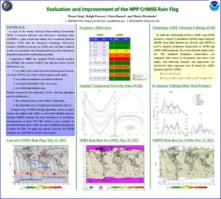
Evaluation and Improvement of the NPP CrIMSS Rain Flag Wenze Yang1, Ralph Ferraro2, Chris Barnet2, and Murty Divakarla2 1. UMD/ESSIC/CICS, College Park, MD Email : ywze98@umd.edu; 2. NOAA/NESDIS, College Park, MD Exact match to AMSU/MHS Simulating AMSU Channels Utilizing ATMS Introduction As part of the Suomi National Polar-orbiting Partnership (NPP), Crosstrack Infrared and Micrwoave Sounding Suite (CrIMSS), a joint system that utilizes the Crosstrack Infrared Sounder (CrIS) and the Advanced Technology Microwave Sounder (ATMS) in synergy, an ATMS only rain flag is utilized to edit out potentially rain contaminated scenes that will lead to degraded temperature and moisture profiles. Comparing to MIRS, the standard NOAA rainrate product via NESDIS, the current CriMSS rain flag has shown several deficiencies, e. g., 1. very little rain is detected in the Intratropical Converg-ence Zone (ITCZ), one of the rainiest regions on the globe; 2. very little precipitation over land is detected; 3. too much mid-latitude rain over ocean; 4. very little high-latitude rain. Possible reasons for the inadequacy of the rain flag algorithm may be attributed to 1. the outdated nature of the AMSU-A algorithm, 2. the algorithm was not implemented properly, and etc. To improve the CriMSS rain flag algorithm, a more accurate scheme that utilizes both AMSU-A and AMSU-B/MHS channels through MSPPS heritage has been introduced, in particular, measurements at above 89 GHz which is more sensitive to precipitation than those which use more traditional channels at or below 89 GHz. To apply the scheme correctly, the ATMS channels are retrofitted to AMSU counterparts. Frequency Differences Only Polarization different Unique Passband Unique Passband, and Pol. different from closest AMSU/MHS channels AMSU ATMS To build the relationship between AMSU and ATMS channels, a bunch of atmospheric profiles (approximately 240,000) from ERA-Interim are selected, and CRTM is used to simulate brightness temperature at ATMS and AMSU-A/B frequencies, for ocean and land, under clear-sky. The simulated brightness temperatures are compared with respect to frequencies and sensor scan angles, and following channels and approaches are selected for final regression, note B stands for AMSU channels and S for ATMS: Angular Comparison Given the Same Profile Evaluation Utilizing Other Rain Products Current CrIMSS Rain Flag, May 15, 2012 MIRS Rain Rate for ATMS, May 15, 2012 MSPPS Rain Rate for ATMS, May 15, 2012