
UNIT 1
E N D
Presentation Transcript
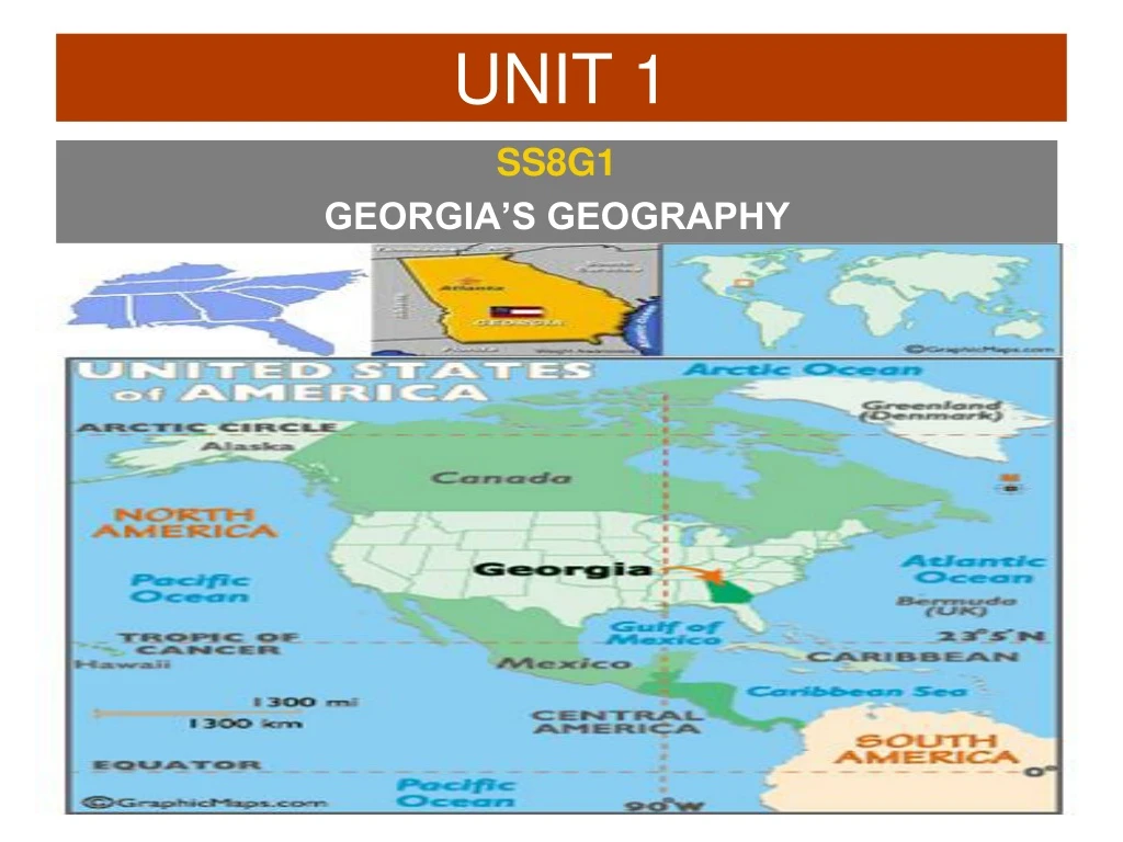
UNIT 1 SS8G1 GEORGIA’S GEOGRAPHY
SS8G1 The student will describe Georgia with regard to physical features and location. Georgia is a state that has a diverse geography. With mountains to the north and the largest swamp in North America to the south, Georgia has quite a unique physical landscape. After studying this standard YOU should be able to describe Georgia’s relative and absolute location, describe its five regions, locate and evaluate the importance of some of Georgia’s physical features, and discuss how Georgia’s climate has impacted the state’s development.
SS8G1aLocate Georgia in relation to region, nation, continent, and hemispheres. Concept: LOCATION
The student will understand that location affects a society’s economy, culture, and development.Why are many places in the world very different from one another?How would you describe the location of Georgia to someone who lives in Japan? Canada? California? LOCATION
SS8G1 GEOGRAPHY of GEORGIA • LOCATION • GEOGRAPHIC REGIONS • PHYSICAL FEATURES
Where in the World is Georgia? • Which hemispheres? • Which continent? • Which nation? • Which region?
SS8G1a • The state of Georgia is located in the southeastern United States. It is located on the continent of North America and it is in the Northern (latitude) and Western (longitude) Hemispheres. • Note: Since Georgia is often referred to as a “Southern State” sometimes students will mistakenly answer that it is located in the “Southern Hemisphere.”
NORTHERN HEMISPHERE WESTERN HEMISPHERE
AME NORTH ICA
Georgiais one of the 50 states in the United States of America
SS8G1b HOW ARE THE FIVE GEOGRAPHIC REGIONS OF GEORGIA SIMILAR? DIFFERENT? ESSENTIAL QUESTION PAGE 3
SS8G1bDescribe the five geographic regions of Georgia; include the Blue Ridge Mountains, Valley and Ridge, Appalachian Plateau, Piedmont, and Coastal Plain. Concept: LOCATION
WHERE ARE THE FIVE GEOGRAPHIC REGIONS OF GEORGIA?HOW ARE THEY SIMILAR?HOW ARE THEY DIFFERENT?
SS8G1b The state of Georgia is divided into five geographic regions. In the north there are three small mountainous regions, each with a differing topography. In the middle of the state is the hilly Piedmont area which is home to many of Georgia’s largest cities including Atlanta. Finally, the state is dominated by the Coastal Plain region which takes up three fifths of Georgia. The Coastal Plain, which is divided into an inner and outer section, was actually covered by water millions of years ago.
Where are the five geographic regions of Georgia? - Appalachian Plateau - Valley and Ridge - Blue Ridge Mountains - Piedmont - Coastal Plains
APPALACHIAN PLATEAU The Appalachian Plateau is located in the northwestern corner of the state and is Georgia’s smallest region. The region is sometimes called the “TAG” region, as the states of Tennessee, Alabama, and Georgia all connect at one point. The region has many scenic areas and is the location of Cloudland State Park. Lookout Mountain, the site of a major Civil War battle, is located in the region, though it is actually in the state of Tennessee.
APPALACHIAN PLATEAU As with the other mountain regions of Georgia, mining was an important economic activity in the region. In the case of the Appalachian Plateau, coal was the most important product. However, unlike the other two northern regions, due to poor soil, agriculture in the Appalachian Plateau is limited.
VALLEY and RIDGE The Valley and Ridge region is characterized by low open valleys and narrow ridges. The area was traditionally a mining region, with the valleys being used for agriculture. The region has several cities and towns, including Cartersville, Calhoun, and Dalton.
VALLEY and RIDGE Dalton is probably the Valley and Ridge’s most important city due to its textile and carpet industry. Historically, this region was a major battle ground during the Civil War and is a major transportation route between Georgia and Tennessee.
BLUE RIDGE MOUNTAINS The Blue Ridge region is located in the northeastern portion of the state. The region is home to Georgia’s largest mountains, including Brasstown Bald the highest peak in the state and the southernmost point of the Appalachian Trail. Important cities in the region include Dahlonega, the site of America’s first Gold Rush.
BLUE RIDGE MOUNTAINS In the past, the primary industry of the region was mining (gold and marble). Today, due to the region’s scenic beauty, it is tourism. The Blue Ridge receives the most precipitation in the state with over 80 inches of rain annually and is the starting point of most of Georgia’s rivers.
PIEDMONT The Piedmont region is in the middle of the state and is the most populous of the five regions. With over 4.5 million people, almost one-half of Georgia’s population lives in the region. Many of Georgia’s most important cities are located in the region including Athens, Atlanta, Augusta, and Macon.
COASTAL PLAINS The largest region in Georgia is the Coastal Plain. Making up three-fifths of the state, this region is actually divided into two areas: the Inner and the Outer Coastal Plain. The Inner Coastal Plain is the agricultural heartland of the state. In this region peaches, peanuts, cotton and the famous Vidalia onions are important crops.
Look at the map key. Which color represents the high elevation of mountains? Which part of the state is highest in elevation? What direction do many of the rivers flow?
SS8G1c HOW ARE PHYSICAL FEATURES IMPORTANT TO GEORGIA’S DEVELOPMENT? ESSENTIAL QUESTION PAGE 4
SS8G1cLocate and evaluate the importance of key physical features on the development of Georgia; include the Fall Line, Okefenokee Swamp, Appalachian Mountains, Chattahoochee and Savannah Rivers, and barrier islands. Concept: LOCATION
? ? ? ? ? ?
Appalachian Mtns Savannah River Fall Line Chattahoochee River Okefenokee Swamp Barrier Islands
What and where is the FALL LINE? The fall line is a natural boundary that separates the Piedmont and the Coastal Plain regions. Due to the drop off of the hilly Piedmont region into the flat Coastal Plain, the waterfalls found on the fall line caused many rivers in the area to be difficult to navigate.
WHERE ARE RIVERS NAVIGABLE IN RELATION TO THE FALL LINE… NORTH OR SOUTH? NAVIGABLE NOT NAVIGABLE
What and where is the FALL LINE? However, the waterfalls did offer sources of water power and many mills were located on the fall line. In addition, many of Georgia’s most important cities such as Columbus, Macon, and Augusta were located on the fall line due to their location as the last navigable upstream points in the state.
THE FALL LINE’S MOST IMPORTANT RESOURCE Kaolin is one of Georgia's largest natural resources. According to the U.S. Geological Survey, more than 8 million metric tons of kaolin are mined from Georgia each year, with an estimated value of more than $1 billion. Georgia is by far the leading clay-producing state in America and is recognized as a world leader in the mining, production, processing, and application of kaolin products. Kaolin in Georgia is generally found in a northeast to southwest band of deposits extending from Augusta to Macon to Columbus. This belt parallels the fall line, which marks the boundary between the Piedmont and the Coastal Plain. Kaolin is most commonly used in the paper-coating industry. It is also used as a filler (added to plastics, for example, and rubber compounds), as a pigment additive in paints, in ceramics (tile, chinaware, and bathroom toilets and sinks), and in pharmaceuticals such as toothpaste. - New Georgia Encyclopedia
What and where is the OKEFENOKEE SWAMP? The Okefenokee Swamp covers 700 square miles and is the largest swamp in North America. Located in southeastern Georgia, the swamp can be found in four Georgia counties. Native Americans lived in the swamp dating back to the Archaic period. The most famous Indian tribe that lived in the swamp was the Seminole, which fought two wars against the United States in the Okefenokee area.
What and where is the OKEFENOKEE SWAMP? White families began settling in the area in 1805. From 1910 until 1937, before Franklin Roosevelt established 80% of the Okefenokee as a wildlife refuge, the swamp was a major source of timber. Now, protected by the federal government, over hundreds of animal species live in the area, the most well known being the American alligator.
What and where are the APPALACHIAN MOUNTAINS? The southernmost point of the Appalachian Mountains is located in Georgia. Georgia’s highest peaks are in the Appalachian Mountain ranges and they can be found in the three mountain regions. In the southern states these mountains are often called the Blue Ridge due to the blue haze that appears around their peaks.
What and where are the APPALACHIAN MOUNTAINS? Long ago, the Appalachians were some of the tallest mountains in the world, though millions of years of erosion have weathered them tremendously. Today the highest peak in Georgia is Brasstown Bald, which has an elevation of over 4700 feet above sea level. In comparison, the highest peak in the continental United States is Mt. Whitney which is almost 14,500 feet.