NOAA Learning Ocean Science through Ocean Exploration Curriculum
730 likes | 976 Vues
NOAA Learning Ocean Science through Ocean Exploration Curriculum. Doing Inquiry-based Science with Students: Direct observation Manipulate variables under natural conditions Use model systems which can be manipulated in the classroom.

NOAA Learning Ocean Science through Ocean Exploration Curriculum
E N D
Presentation Transcript
NOAA Learning Ocean Science through Ocean Exploration Curriculum • Doing Inquiry-based Science with Students: • Direct observation • Manipulate variables under natural conditions • Use model systems which can be manipulated in the classroom
Learning Ocean Science through Ocean Exploration of necessity concentrates on using model systems. • Essential that students understand the relationship between the model and the real thing. OE website gives them access to the real thing.
LESSON PLAN 2 Page 16 A WATERED-DOWN TOPOGRAPHIC MAP
1897 Contoured Map of Monterey "Submerged Valley," Now Called Monterey Canyon
Bathymetric contour map of Davidson Seamount, showing the dive tracks for each day.
About 200 miles from Woods Hole, MA, flat-topped Bear Seamount rises approximately 2000 meters from the surrounding ocean floor to a depth of 1100 meters.
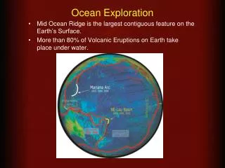
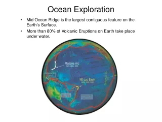
Mid-ocean Ridge SystemEarth’s longest mountain range (35,000 miles)2/3 of Earth’s surface formed at mid-ocean ridges
Above Sea Level 400’ 300’ 200’ 100’ 0
Below Sea Level 100’ 100’ 200’ 200’ 300’ 300’ 400’ 400’ 500’ 500’
Land or Sea? 100’ 100’ 200’ 200’ 400’ 300’ 100’ 200’ 200’ 300’ 100’ 300’ 400’ 300’ 400’ 400’ 500’ 500’
A Watered-down Topographic Map • Part 1 • Students would use the descriptions to make the geologic features in a MODEL ocean. The geologic features have been pre-built with clay for this workshop in the interests of time. • Part 2 • Read the cards to decide which feature you have. Follow the student worksheet to make a bathymetric contour map your feature. • Read all the instructions BEFORE you start!!
LESSON PLAN 4 Page 25 Mapping Deep-sea Features
Gulf of Alaska Expedition False-color Multibeam Data Over Satellite Imagery
Mapping Deep-sea Features Translate a data table into a false color image map and then into a 3-D model of a seamount 1. Use the Student Handout with depth ranges and the Bathymetric Data Reduction table to make a false color map. 2. Make a 3-D visualization of a seamount or a submarine canyon. Assemble the foam pieces in the same color order from deepest on the bottom to shallowest on top.
Bathymetric Map of Loihi Volcano, Hawaii’s Youngest, Off the Southeastern Coast of the Big Island
www.learningdemo.com/noaa/ NOAA Learning Object Lesson 4 Subduction Zones Use “Bathymetric Maps” as a possible follow-up activity/assessment activity after Lesson Plans 2 and 4
LESSON PLAN 8 Page 64 The Biggest Plates on Earth
Convergent Plate Boundaries Oceanic to Continental Oceanic to Oceanic
www.learningdemo.com/noaa/ NOAA Learning Object Lesson 2 Mid-ocean Ridges Use “Seafloor Spreading Activity” as a possible follow-up activity/assessment activity after LP 8.
LESSON PLAN 9 Page 69 The Galapagos Spreading Center
www.learningdemo.com/noaa/ NOAA Learning Object Lesson 2 Mid-ocean Ridges Use “Explore Mid-Ocean Ridges” as an introductory activity for LP 9. Use last segment of “Lesson” to introduce formation of hydrothermal vents.
LESSON PLAN 11 Page 80 Volcanoes, Plates, Seamounts, and Island Chains
LP 8, 9 & 11 – Ocean Literacy Essential Principles and Fundamental Concepts EP 1 Earth has one big ocean with many features FC b. Ocean basins features vary due to movement of Earth’s lithospheric plates. EP 2 The ocean shapes Earth’s features FC e. Tectonic activity influences physical structure and landforms.
LESSON PLAN 13 Page 100 All That Glitters…