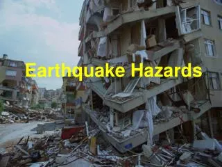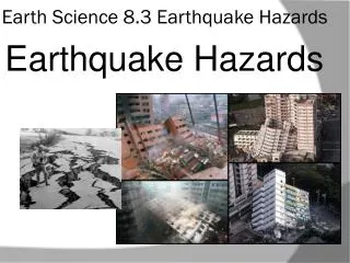
Earthquake Hazards
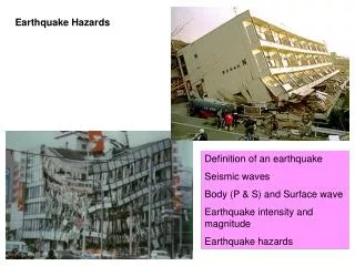
Earthquake Hazards. Definition of an earthquake Seismic waves Body (P & S) and Surface wave Earthquake intensity and magnitude Earthquake hazards. Earthquake size and hazards. Ground displacement and ground shaking Earthquakes are caused by slip along faults.

Earthquake Hazards
E N D
Presentation Transcript
Earthquake Hazards Definition of an earthquake Seismic waves Body (P & S) and Surface wave Earthquake intensity and magnitude Earthquake hazards
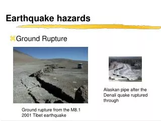
Earthquake size and hazards • Ground displacement and ground shaking • Earthquakes are caused by slip along faults. • When the fault blocks move, they displace the surface, either vertically or horizontally.
Earthquake size and hazards • Ground displacement and ground shaking • Strike-slip: horizontal displacement • 1906 M 7.6 San Francisco EQ: 270 mile long rupture, the 25 feet of right-lateral offset! • Oct 16, 1999, M 7.1 Hector Mine EQ near Joshua Tree National Park in southern California Mojave Desert • 25 mile long surface rupture that moved 15 feet instantaneously!
Earthquake size and hazards • Ground displacement and shaking • Dip-slip: vertical displacement • 1994 Northridge EQ of southern California, one side went up 30 centimeters • 1964 Good Friday EQ of Alaska, max upward was 39 feet, max downward 52.5 ft • Do not build on a fault trace • Mostly done with zoning
Earthquake size and hazards • Groundshaking
Earthquake size and hazards B. Liquefaction Conversion of unconsolidated sediments with some initial cohesiveness into a mass of water-saturated sediment that flow like a liquid (but no water is added) No longer able to support structures, they sink into the ground like quicksand
Earthquake size and hazards • B. Liquefaction • Fine, moist sediment is shaken, the shaking increases the water pressure between grains, forcing them apart • Without the frictional contact between grains, the sediment loses its cohesiveness and strength • Once firm ground becomes a slurry of mud or sand
Earthquake size and hazards C. Landslides Ground shaking can dislodge large masses of unstable rocks, especially areas that have experienced liquefaction Example: Turnagain Heights in Anchorage, Alaska 1964 quake 200 acres of land slid toward the ocean, worthless for further development so now “Earthquake Park”
Earthquake size and hazards • D. Tsunamis • Seismic sea waves (Japanese for harbor wave)(media = tidal waves) • Most caused by vertical displacement along a fault on the ocean floor, or by a large underwater landslide caused by an earthquake • Offset of ocean floor shoves water like a paddle, creates waves which spread out in all directions away from the quake, similar to ripples away from a stone in a lake • Travel at speeds between 300 and 600 mph!!!”
Earthquake size and hazards D. Tsunamis Waves: In open ocean: barely perceptible, only 3 feet high—wavelengths are 60-450 miles! In near shore, the drag against the ocean floor causes the fast moving waves to bunch up Usually <100 feet high, largest was 210 feet!!! (20 story building) Usually consist of several waves that arrive at irregular intervals over several hours Warnings: an offshore earthquake and rapid withdrawal of water from the beaches
Earthquake size and hazards D. Tsunamis Examples: 1960 M9.5 Chile EQ 15 hours later a tsunami hit Hilo, Hawaii, killed 61 people 22 hours after the quake, tsunami hit Honshu and Hokkaido, Japan, killing 180 (had traveled 11,000 miles!)
Sumatra Earthquake Magnitude: 9.3 Date-time: Sunday, December 26, 2004 at 7:58:53 AM (local time) Depth: 30 km (18.6 miles) Distances: * 250 km (155 miles) SSE of Aceh, Sumatra, Indonesia * 310 km (195 miles) W of Medan, Sumatra, Indonesia * 1260 km (780 miles) SSW of Bangkok, Thailand * 1605 km (990 miles) NW of Jakarta, Java, Indonesia Source: UnitedStates Geological Survey (USGS)
Basic Tsunami Mechanism • An earthquake causes a vertical movement of the seafloor, which displaces the sea water. • Large waves then radiate from the epicenter in all directions.
A tsunami is series of traveling ocean waves of extremely long length generated primarily by earthquakes occurring below or near the ocean floor. • Tsunami waves propagate across the deep ocean with a speed exceeding 800 km/h ( 500 mph) and a wave height of only a few tens of centimeters or less. • As they reach the shallow waters of the coast, the waves slow down and their height increases up to tens of meters (30 ft) or more. Tsunami Explained Source: NOAA
Tsunami Translated Japanese word: “Tsu“ means “harbor” English translation: “Harbor wave” “Nami“ means “wave” • “Tidal wave” is a misnomer because the cause is unrelated to tides. • “Seismic sea wave” is misleading because a tsunami can be caused by non-seismic events, and it is not dangerous in the open ocean.
Water Recession: A Precursor Draw Down Effect Wave Generation From: Nature Publishing Group From: Nature Publishing Group Kalutara Beach, Sri Lanka From: Digital Globe
Tsunami Wave Appearance Source: www.waveofdestruction.org • A tsunami wave crest has three general appearances from shore: • Fast-rising tide • Cresting wave • A step-like change in the water level that advances rapidly (called a bore) A bore on the Qian Tang Jiang River, China • Series of waves • Most tsunamis come in a series of waves that may last for several hours • The outflow of water back to the sea between waves can cause more damage than the original incoming wave fronts • The first wave is rarely the largest
Tsunami Propagation National Institute of Advanced Industrial Science and Technology, Japan
Tsunami Propagation National Institute of Advanced Industrial Science and Technology, Japan
Earthquake size and hazards Downtown Hilo, Hawai’i
Earthquake size and hazards D. Tsunamis Examples: 1964 Alaskan quake 109 of the 131 deaths were from a tsunami Tsunamis hit Oregon and California killing 16 more In Crescent City, CA: first wave 4 meters high, then 3 more smaller waves, then people thought it was over and went down to the beach 5th wave was >10 m
Earthquake size and hazards D. Tsunamis 1993 EQ near Okushiri, Japan Water reached 50-100 ft above sea level Reached land in 2-5 minutes after the quake Killed 120 people and caused $600 million in damage Tsunami warning systems in Hawaii *worst places - little warning, coasts off subduction zones, Pacific NW coast, Hawaii, Japan
Draft tsunami safety flyer for Crescent City Motels, Del Norte County Office of Emergency Services • TSUNAMI (TIDAL WAVE) SAFETY • IF YOU FEEL A STRONG EARTHQUAKE WHICH LASTS A LONG TIME (20 SECONDS OR MORE) WHEN YOU ARE ON THE COAST: • Protect yourself during the earthquake. Duck, cover and hold if inside and watch for falling objects until the earthquake is over. • Move to higher ground immediately AND inland away from the coastline. In Crescent City move north of 9th Street. Gather your family members and evacuate quickly. Leave everything else behind. A tsunami may be coming within minutes. Go on foot if at all possible. • DO NOT WAIT FOR AN OFFICIAL WARNING !!!
Simulation of a Cascadia earthquake and tsunami This computer-generated image shows the tsunami produced by the great Cascadia earthquake of January 26, 1700, six hours after initiation. The tsunami moved across the Pacific Ocean and produced destructive waves up to several metres high along a 1000-km length of the coast of Honshu in Japan. Much larger waves struck the west coast of North America less than 30 minutes after the shaking stopped.
Pacific-North America plate boundary • Convergent boundary in PNW • Subduction zone earthquakes • Ground shaking • Liquefication • Landslides • Tsunami • Secondary fault rupture
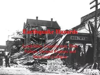
Earthquake size and hazards E. Fire Greatest damage often caused by fire after the quake EQ’s damage gas pipelines, oil tanks, and electrical power lines which then often start fires after the quake Ruptured water mains - no way to put the fires out 1923 Kanto EQ, in Tokyo-Yokohama, Japan High winds caused fires to spread quickly, 500,000 buildings lost and 140,000 lives
Earthquake size and hazards E. Fire 1999 Kobe EQ, Japan
Earthquake size and hazards E. Fire 1906 earthquake quake in San Francisco fires caused 80-90% of the damage Fire lasted 3 days Destroyed 508 square blocks 1906 San Francisco earthquake
Earthquake size and hazards E. Fire 1906 earthquake quake in San Francisco fires caused 80-90% of the damage burned for 3 days Destroyed 508 square blocks 1906 San Francisco earthquake
Earthquake hazards The potential losses from a repeat of the 1906 Earthquake on the same section of the San Andreas Fault are staggering. Such a worst case event could cause 3,000 to 8,000 deaths and 170 to 225 billion dollars in property losses. 90% of these losses will occur from strong ground shaking. Three surviving structures in the Financial District
Earthquake size and hazards F. Seiches (saysh = seiche) Water in an enclosed or partially enclosed body of water (lake or bay) to slosh back and forth, rising and falling (rhythmic sloshing) May occur thousands of miles from the epicenter Especially a problem in reservoirs behind earthen dams Sloshing weakens the dams and they may collapse
Earthquake size and hazards F. Seiches (saysh = seiche) Example: 1964 Good Friday quake in Alaska Kenai Lake, south of Anchorage, water at one end rose 30 feet, overflowed its banks and flooded inland, then reversed—striped shores down to bedrock Seiches occurred in reservoirs as far away as Michigan, Arkansas, Texas & Louisiana Seiches in swimming pools in Texas, ~4000 miles away! In bays along the Gulf coast, water rose and fell 6.5 feet, damaging boats by knocking them into each other & docks
Earthquake size and hazards F. Seiches (saysh = seiche) Example: 1959 Madison Canyon earthquake in Montana The Hebgen Lake dam overflowed because of a seiche that oscillated back and forth across the lake every 17 minutes for 11 hours
Earthquake Magnitude and Intensity Intensity is a measure of the effects of an earthquake at a particular place on humans, structures and (or) the land itself. The intensity at a point depends not only upon the strength of the earthquake (magnitude) but also upon the distance from the earthquake to the point and the local geology. Richter Magnitude is a measure of the strength of an earthquake, as determined by seismographic observations. An increase of one unit of magnitude (M3 to M4) represents a 10-fold increase in wave amplitude on a seismogram or approximately a 30-fold increase in the energy released.
Most Destructive Known Earthquakes on Record in the World (> 50,000 deaths) (Listed in order of greatest number of deaths) Date Location Deaths M Comments January 23, 1556 China, Shansi 830,000 October 11, 1737 India, Calcutta** 300,000 July 27, 1976 China, Tangshan 255,000* 8.0 August 9, 1138 Syria, Aleppo 230,000 May 22, 1927 China, near Xining 200,000 8.3 Large fractures. December 22, 856+ Iran, Damghan 200,000 December 16, 1920 China, Gansu 200,000 8.6 Major fractures, landslides. March 23, 893+ Iran, Ardabil 150,000 September 1, 1923 Japan, Kwanto 143,000 8.3 Great Tokyo fire December 28, 1908 Italy, Messina 70,000 7.5 Deaths from to 100,000 earthquake & tsunami. September, 1290 China, Chihli 100,000 November, 1667 Caucasia, Shemakha 80,000 November 18, 1727 Iran, Tabriz 77,000 November 1, 1755 Portugal, Lisbon 70,000 8.7 Great tsunami December 25, 1932 China, Gansu 70,000 7.6 May 31, 1970 Peru 66,000 7.8 Great rock slide and flood 1268 Asia Minor, Silicia 60,000 January 11, 1693 Italy, Sicily 60,000 May 30, 1935 Pakistan, Quetta 30,000 7.5 Quetta almost completely destroyed (~60,000) February 4, 1783 Italy, Calabria 50,000 June 20, 1990 Iran 50,000 7.7 Landslides. * Official casualty figure--estimated death toll as high as 655,000. + Note that these dates are prior to 1000 AD. No digit is missing. ** Later research has shown that this was a typhoon, not an earthquake. (1737 Calcutta Earthquake Bilham, 1994)
Plate Tectonics 95% of earthquakes occur along the edges of the interacting plates Source: Earthquakes by Bruce A. Bolt
Earthquake Energy Sumatra-Andaman (2004) Source: Earthquakes by Bruce A. Bolt