NASA Earth Science Enterprise Overview
NASA Earth Science Enterprise Overview. NASA’s Earth Science Enterprise. Ronald J. Birk Special Assistant to Associate Administrator version 2.0. Strategy Hierarchy. Research Strategy. Applications Strategy. Technology Strategy. www.earth.nasa.gov. NRC. IPCC. USGCRP. Global Change .

NASA Earth Science Enterprise Overview
E N D
Presentation Transcript
NASA Earth Science EnterpriseOverview NASA’s Earth Science Enterprise Ronald J. Birk Special Assistant to Associate Administrator version 2.0
Strategy Hierarchy Research Strategy Applications Strategy Technology Strategy www.earth.nasa.gov
NRC IPCC USGCRP Global Change Advanced Weather Prediction National Hazards Center SESWG NRC Natural Hazards Roundtable Natural Hazards Earth Science Enterprise Earth Science Knowledge Mission: Focus on weather, climate, & natural hazards Science Industry Tribal Applications Local State Federal Operational Imperatives Technology & Missions Transition Validation & Verification Applications Demonstration Applications Research
Roadmap from Data to Decision Support - Knowing what crops to grow next summer Autonomous, In-space Calibration and Data Reduction Interaction Between Modeling/Forecasting and Observation Systems Interactive Dissemination Petabytes Multi-platform, multi-parameter, high spatial and temporal resolution, remote & in-situ sensing Terabytes Gigabytes Megabytes WET VERY DRY DRY WET WET DRY DRY VERY WET Predictions Access to Knowledge Information Synthesis Advanced Sensors Processing Webs COLD WARM COLD
NASA’s Earth Science Enterprise Pioneers Scientific Observation of the Earth Our Mission: Develop a scientific understanding of the Earth system and its response to natural and human-induced changes to enable improved prediction of climate, weather, and natural hazards for present and future generations
Science Views Earth as a Dynamic System Forces acting on the Earth system Earth system response IMPACTS Feedback Of the total forcing of the climate system, 40% is due to the direct effect of greenhouse gases and aerosols, and 60% is from feedback effects, such as increasing concentrations of water vapor as temperature rises.
ScienceQuestions • How is the global Earth system changing? • What are the primary causes of change in the Earth system? • How does the Earth system respond to natural and human-induced changes? • What are the consequences of changes in the Earth system for human civilization? • How well can we predict future changes to the Earth system?
Measurement Requirements for NASA Earth Science Research Strategy Variability Forcing Response Consequence Prediction Precipitation, evaporation & cycling of water changing? Atmospheric constituents & solar radiation on climate? Clouds & surface hydrological processes on climate? Weather variation related to climate variation? Weather forecasting improvement? Global ocean circulation varying? Changes in land cover & land use? Ecosystem responses & affects on global carbon cycle? Consequences in land cover & land use? Transient climate variations? Global ecosystems changing? Surface transformation? Changes in global ocean circulation? Coastal region change? Trends in long-term climate? Stratospheric ozone changing? Stratospheric trace constituent responses? Future atmospheric chemical impacts? Ice cover mass changing? Sea level affected by climate change? Future concentrations of carbon dioxide and methane? Motions of Earth & interior processes? Pollution effects? Requires both systematic & exploratory satellites Requires systematic satellite observations Requires exploratory satellite observations Requires pre-operational and/or systematic/expl Use available/new observations in better models 12/20/00
ESE Spaceborne Missions Systematic Missions-Observation of Key Earth System Interactions Terra Landsat 7 Aqua Aura QuikSCAT ICEsat Jason-1 SeaWinds Exploratory - Exploration of Specific Earth System Processes and Parameters and Demonstration of Technologies GIFTS SRTM GRACE Cloudsat EO-1 Triana CALIPSO
Land, Oceans, Atmosphere EOS Era • NPOESS Preparatory Project (2005/06) • Landsat Data Continuity Mission (2005) • Global Precipitation Mission (2007) • Ocean Topography Mission (2006) • Ocean Surface Winds (2006) • Total Column Ozone/Aerosols (2008) • Solar Irradiance (2006) Terra, Aqua Landsat 7 TRMM TOPEX, Jason QuikSCAT, SeaWinds TOMS, OMI ACRIMsat, SORCE
Exploratory Measurement Needs Soil moisture Gravity field (GRACE) Stratospheric aerosols (CALIPSO) Land surface topography/deformation Cloud particle properties (Cloudsat) Snow cover/Freeze-thaw transition Biomass changes (VCL) Carbon sources & sinks Ocean salinity Sea ice thickness Atmospheric properties in tropopause region Ice sheet velocity fields Tropospheric ozone & precursors How are global precipitation, evaporation, and the cycling of water changing? (V1) What are the motions of the Earth and Earth’s interior? (V6) What trends in atmospheric constituents and solar radiation are driving global climate? (F1) How is the Earth’s surface being transformed…? (F2) What are the effects of clouds and surface hydrological processes on climate change? (R1) How do ecosystems respond to and affect global environmental change and the global carbon cycle? (R2) How can climate variations induce changes in global ocean circulation? (R3) How do stratospheric trace constituents respond to change in climate and chemical composition? (R4) How is global sea level affected by climate change? (R5) What are the effects of regional pollution on the global atmosphere…? (R6)
Remote Sensing Data Types Thermal Multispectral Hyperspectral Scatterometer Lidar Synthetic Aperture Radar
Private Sector RS Systems IKONOS SPIN-2 SPOT 4 QuickBird Orbview 3 EROS A1
Airborne RS Systems • Positive Systems ADAR • ESSI Probe • WEI LaserMap • Daedalus TMS • ITRES CASI • TerraSystems DMSV • Intermap STAR-3i • EarthData Lidar • Emerge MSI • Eaglescan Lidar • Calgis GEOSAR • ERIM Air Lidar
Technology Emphasis Areas Earth System Science in the future will leverage three ongoing technology revolutions: Geospatial Computing Communications ...To enable timely and affordable delivery of Earth Science data and information to users
LIDAR Roadmap Atmospheric Chemistry, Clouds/Aerosols Scanning H2O DIAL LASER Altimetry Direct CO2 Multi-kHz microlaser altimeter ~cm 3D res. Doppler Winds (Direct Detection) UV DIAL O3 & trace gases X2 lifetime >efficiency <mass, cost 3 J @ 355 nm 10 m ø telescope 50% eff det. P-C clouds & aerosols H/V res. 250 m/30 m 0.1 - 0.5 m hgt. res. Increasing Capability Doppler Winds (Coherent Detection) 1 J @ 355 3 m ø telescope 35% eff. Det. holographic scanning ICESAT 100mJ, 40Hz .8 m optics NPOESS 1 J, 12.5 Hz .75 - 1 m optics VCL <1m hgt. res. 300 mJ @ 355 nm 1 m ø telescope 25% eff. det. 500mJ, 10Hz .5 m optics 2000 2007 2015 Time
Reconfigurable CommunicationsDistributed Information-System-in-the-Sky Optical Crosslink Optical Crosslink Ka Crosslink Active Optical Ka Ka Ka Passive Optical Comm Gateway Data Mining/ Date Fusion Sites Metadata Warehouse Commercial Communication Network • Interoperating Measurement Systems (Air / Spacecraft / In-situ) • Flexible Measurement Network Architecture • Direct Distribution of Derived Products • Network Computing- in-the-Sky In-situ User PC Based GS Internal NASA Use Only
Computational Climate Modeling Fully intera ctive (biol ogy, Computational Modeling in Two Stages; Computational Modeling in Two Stages; chemistry, physic s) ensemble sim ulations in Driving Evolution & Enabling Revolution Driving Evolution & Enabling Revolution an operati onal mode 2020 ° ° .25 x .25 resolution; 2015 add cloud, che mistry, & radiat ion effects 16 10 2010 ° ° .25 x .25 resolution; 15 hurricanes, storm front s 10 2005 14 10 ° ° 2 x 2 resolution; Interact ive Nanotechnology synoptic scale s physics, biology, chemistry; 13 10 Revolutionary Revolutionary assimilat ion of satelli te data Data Size, Bytes 12 10 2001 Homogeneous 11 Cluster Informati on 10 Heterogeneous Power Grid Cluster Evolutionary Evolutionary 10 10 ExaFLOPS TeraFLOPS PetaFLOPS GigaFLO PS 9 10 9 10 11 12 13 14 15 16 17 18 10 10 10 10 10 10 10 10 10 10 Compute Speed, FLOPS Real Demonstrated Performance doin g useful Science
EOSDIS Science Data Flight Operations, Distribution, Data Processing, Data Acquisition Data Capture, Access, Transport Info Mgmt, Data Initial Processing, Interoperability, to DAACs Archive, & Distribution Reuse Backup Archive Research Users Tracking EOS & Data Spacecraft Relay Satellite (TDRS) Distributed Active Archive Centers NASA Integrated Data Processing & Mission Control Services NASA Internet Network (NISN) Mission Services Education Users White Sands Complex (WSC) Value-Added Providers Instrument Teams Int’l Partners Interagency EOS Polar Ground Stations Centers & Data Data Centers
Earth System Modelling Land GTEC BIOME-BGC CENTURY BIOME3 TEM Oceans ROMS HOPE OCCAM POM Atmosphere MM5 AGCM GISS Hadley Center
Science Goals TODAY Goals for 2010 5-Day forecast at >90%* 7-10 Day forecast at 75%* 3 day rainfall forecast routine Hurricane landfall +/-100Km at 2-3 days Air quality forecast at 2 days 6-12 month seasonal prediction routine;12-24 months experimental 10 year climate forecasts experimental; moderate to high confidence in forcing & response factors Continuous monitoring of surface deformation in vulnerable regions with millimeter accuracy Improved temporal dimension of earthquake & volcanic eruption forecasts Improve post-eruption hazard assessment 3-Day forecast at 93%* 7 Day forecast at 62%* 3 day rainfall forecast not achievable Hurricane landfall +/-400Km at 2-3 days Air quality day by day 6-12 month seasonal prediction experimental; achieved an understanding of El Nino mechanics Decadal climate prediction with coarse models and significant uncertainties in forcing and response factors Demonstrate centimeter-level measurement of land deformation Accurate characterization of long-term tectonic motions, but no short-term earthquake forecast capability Accurate characterization of volcanic activity, but no long-term prediction accuracy Weather Climate Natural Hazards * Accuracy refers to sea level pressure forecasts over Northern Hemisphere during winter.
Evolution of Earth Science at NASA • 1960s to 1980s: Exploring the Possibilities • Birth and early development of satellite remote sensing • Technology demonstration was the driver • 1990 to 2000: Surveying the Earth System • Birth and evolution of the Earth System Science concept • Focus on providing a broad suite of observations to observe, document and understand Earth system change • 2000 to 2020: Focus on National Needs • Answer high-priority science questions with profound national/international economic and policy relevance • End-to-end science, technology & applications approach • 2020 and Beyond:Enabling Ubiquitous Use of the View From Space • Information delivery from space to decision-makers’ desktops in a timely and affordable manner
Applications Imperative Putting (ESE) knowledge to work (NRC 2001): Ensure an “intimate connection” to extend research and technologies being developed by the Enterprise through partnerships with Federal Agencies, Academia, and the Private Sector on operational activities to baseline solutions for decision support systems to serve the national interest Weather Prediction Aviation Safety Intelligent Transportation Systems Precision Agriculture
ESE and Applications Missions The NASA Earth Science Enterprise mission is to: • “Develop a scientific understanding of the Earth system and its response to natural and human-induced changes to enable improved prediction of climate, weather, and natural hazards for present and future generations.” The Enterprise Applications Program mission is to: • “Expand and accelerate the realization of economic and societal benefits from Earth science, information, and technology.” (ESE, Strategic Plan 2001)
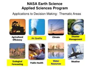
Theme Areas • Resource Management Management of renewable and nonrenewable natural resources including: Agriculture, Forestry, Rangeland, Fisheries, Fossil Fuel, Extraction, Renewable Energy. • Disaster Management Natural hazards applied research and applications development, manmade disasters: Earthquakes, Volcanic Eruptions, Landslides, Wildfires, Floods, Severe Storms, Tsunamis, Coastal Change, and Land subsidence. • Community Growth and Infrastructure Transportation, Infrastructure and Utilities, Urban Planning, and Conservation/Preservation, and Human Impacts on land use. • Environmental Assessment Assessment of Air, Water, and Land environments, and Ecosystems, and the effect of natural and human-made changes on these environments.
Program Prioritization Criteria Priority Criteria Socioeconomic Value Application Feasibility Mandated Program Appropriate for NASA Partnership Opportunity* Science & Technology Readiness Program Balance Cost / Budget Context * Includes potential for handoff to operational systems Implementation Priority Criteria
Socioeconomic Value Weather & Energy • The annual cost of electricity could decrease by at least $1B if the accuracy of 30 hour weather forecasts improved 1 degree Fahrenheit. Earth Science & Aviation • The projected annual savings of operating aircraft using advanced Synthetic Vision Systems at just 10 airports in the U.S. in one year is over $2B.
Vision for 2025 and Beyond • Enabling Ubiquitous Use of the View From Space • Information delivery from space to decision-makers’ desktops in a timely and affordable manner Local Governments Federal Agencies Universities NASA Centers State Governments Scientists International Partners
Agreements • USDA Ag 20/20Precision Agriculture • FEMA Flood Map Modernization Program • USGS National Map Program • NOAACoastalLand Use & Land Cover Mapping • NIMA Homeland Security • DOT Intelligent Transportation Systems • FGDC National Spatial Data Infrastructure • USAID Vulnerability Assessments • CCAD Biological Corridor Analysis • NIH Early Warning forVector borne diseases
Spatial Information Cycle Prediction Models NASA ESE Private Public EOS, ESSP NMP EOSDIS, ESIP 24 Measurement Sets Decision Support Systems Tasking Distribution • Evaluation • Verification • Validation • Demonstration Data Distribution/ Management Data Sources/ Measurements Standards- based Products Exploitation Processing
Program Outputs Verification and Validation Reports • Benchmark approach and results of analysis Application Prototypes and Guidelines • Documented prototypes and guidelines (procedures) that can serve as benchmarks for potential operational implementation Assessment for Commercial Implementation • Analyses of limitations of solutions based on currently available technologies Guidance for Next Generation R&D • Recommendations for next generation investments in earth science and technology research and development
Improving Efficiency of Agriculture An applications research project with the University of Kansas has led to it’s spinning off a new business in crop yield forecasting A partnership with USDA and four growers associations representing 100,000 US farmers is demonstrating new techniques for precision agriculture
Managing Wildfires The US Forest Service has established two direct broadcast receiving installations to acquire Terra satellite data, and enable daily, near real-time distribution and decision making on allocation of fire fighting assets.
Informing Aviation • Digital Atmospheric Data • Digital Terrain Data
RTCA Aviation Terrain Database Specs AREA 1 The World AREA 2 Terminal AREA 3 Aerodrome LE90 Horizontal Accuracy 50 m 2.5 m 5 m Data Integrity Routine (10-3) Essential (10-5) Essential (10-5) Vertical Accuracy 30 m 1.0 m 3 m Vertical Resolution 1.0 m 0.1 m 0.1 m Confidence level 90% 90% 90% Publication Timeliness As required As required As required 0.3 arc sec (10m) 1.0 arc sec (30m) 3.0 arc sec (100m) Post Spacing Source SRTM IFSAR Lidar
ESE Results for Aviation Roadmap NASA NOAA Research Operations 2002 2003 2005-2006 2008-2010 PAVE GAP SCIENCE GIFTS DEMO Meteorology NAST-I (ER-2) AIRES (AQUA) CrIS (NPP) TECHNOLOGY GIFTS GOES-R (5) Applications Research Validation & Verification Applications Demonstration Aviation Weather Information FAA Integrated Product Development Team APPLICATIONS Prod. Dev. Phase - 2 Prod. Dev Phase - 3 Prod. Dev. Phase - 1
Application Scenarios • Weather and Aviation • Weather, Climate and Agriculture/Forestry • Weather, Climate, Natural Hazards and Community Disaster Preparedness • Weather, Climate and Human Health • Weather, Climate and Energy • Weather, Hazards and Homeland Security
Partnerships • Public Sector • Academic Sector • Research Sector • Private Sector • Centers of Excellence
NASA Centers + Goddard Space Flight Center + NASA Langley Research Center +
Regional Earth Science Applications Centers Larry/programs/resacs/resacs_map_w_text.ppt
Summary • ESE focuses on extending the use of Earth science and remote sensing technologies through applications for nationally important areas of decision support. • ESE provides systems engineering and verification and validation within a framework of the elements of data sources, data products, data distribution, and decision support systems associated with geospatial information. • ESE works in partnerships with information community. • Our challenge and opportunity is to identify, and realize the potential for, earth science and remote sensing technology solutions to contribute spatial information products to serve decision support system objectives that are in the national interest.
Applications Advanced Products & Technology Development Community Growth and Infrastructure Transportation, Infrastructure and Utilities, Urban Planning, and Conservation / Preservation, and Human Impacts on land use. Resource Management Management of renewable and nonrenewable natural resources including: Agriculture, Forestry, Rangeland, Fisheries, Fossil Fuel, Extraction, Renewable Energy Disaster Management Natural hazards applied research and applications development, manmade disasters: Earthquakes, Volcanic Eruptions, Landslides, Wildfires, Floods, Severe Storms, Tsunamis, Coastal Change, and Land subsidence. Environmental Assessment Assessment of Air, Water, and Land environments, and Ecosystems, and the effect of natural and human-made changes on these environments. Exploratory Multi-Theme Land use/Land cover; Weather & Climate