Download
1 / 16
160 likes | 275 Vues
This study aims to explore the feasibility of approximating tidal datums with a precise gravimetric geoid combined with data from tide gauges or GPS buoys. Conducted aboard the Bertram in May 2002, the research involved a comprehensive survey measuring sea surface height and ship attitude across multiple tide gauges. Using advanced GPS technology and inertial navigation systems, the investigation seeks to connect tidal datums and global geoids, addressing challenges related to ellipsoid references. Our findings indicate potential for using ships as continuous tide gauges to improve accuracy in measuring sea levels.

E N D
Tide corrections from KGPS and a precise geoid John Brozena, Randy Herr, Vicki Childers
Goals of Program • Determine the extent to which we can approximate a tidal datum from a precise gravimetric geoid and an offset determined from one or more tide gauges or GPS buoys • i.e. Can we extrapolate a tidal datum from a tidal gauge out into the open water using a geoid and KGPS measurements?
NRL/NAVO Bertram Test • Three day survey in May 2002 • Conducted aboard the Bertram from Gulfport tide gauge • Sea surface height plus ship attitude information measured while repeatedly traveling between four tide gauges: Gulfport, Ship Island, Waveland, and Point Cadet. • The first three of these have been referenced to the ellipsoid by static GPS surveys.
Bertram Instrumentation • Ashtech Z12 dual-frequency GPS receiver • GPS antenna mounted on mast above bridge • Inertial navigation system and tilt meter for attitude information • The Gulfport tide gauge was set up as the GPS base station
Initial Reference Frame Concerns • GPS is referenced to an ellipsoid whereas tide gauges are referenced to a tidal datum • At each GPS-surveyed tide gauge, the antenna was referenced to the gauge’s tidal staff and to its electric gauge • On the boat, the antenna must be referenced to the sea surface
Roll Ship-Antenna Geometry: Changes in Attitude • GPS solution locates the antenna atop the boat • Need to relate antenna position to sea surface (or need instantaneous keel depth) • Vertical distance changes with static draft, dynamic draft, and boat-antenna lever-arm geometry Squat
Ship as Tide Gauge • “Reducing” the GPS position to the water level yields an instantaneous measurement of water surface with respect to the ellipsoid • If the local offset between the ellipsoid and the tidal datum can be determined, the ship can become a continuous free-floating tide gauge
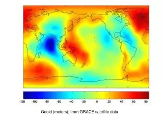
Connecting the Tidal Datum to the Ellipsoid • Tidal datum is defined locally as a long-term average of low tides as measured by a tide gauge. • Global geoid is the gravitational equipotential surface that approximates MSL on a global basis. • MSL deviates from the geoid due to oceanographic and atmospheric effects • Effects can be approximated by a geoid with a constant or slowly varying offset.
Chesapeake Bay Airborne Survey • P-3 airborne sea-surface height measurement over 8 tide gauges in the bay • SSH calculated using GPS heights and a radar altimeter • Geoid 99 is a relatively good geoid for the region but high frequency information is lacking • 3 cm rms accuracy for survey
Bertram Gulfport Survey • Each day began at the Gulfport tide gauge with half hour GPS collection at port • Bertram traveled to each of the other three tide gauges repeatedly, returning to the Gulfport gauge in between • Half hour occupations at the other tide gauges were also performed several times daily to help constrain biases associated with antenna-boat geometry, the geoid, and the links into each gauge.
Summary • Work is in progress • Encouraged by our first view of the data • Expect to demonstrate how the sea surface as measured with GPS can be related to the tidal datum using a combination of geoid, hydrodynamic models, and tide gauges. • Thanks for the great job from the NAVO crew