Download
1 / 9
90 likes | 176 Vues
Spatial Data Infrastructure (SDI) facilitates access to spatial data for various sectors. Learn about its components and significance for data sharing and utilization. Discover how SDI promotes data discovery and integration, aiding users and providers at all levels.

E N D
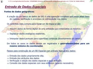
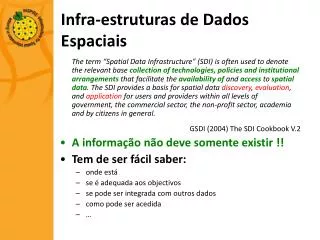
Infra-estruturas de Dados Espaciais The term “Spatial Data Infrastructure” (SDI) is often used to denote the relevant base collection of technologies, policies and institutional arrangementsthat facilitate the availability of and access to spatial data. The SDI provides a basis for spatial data discovery, evaluation, and application for users and providers within all levels of government, the commercial sector, the non-profit sector, academia and by citizens in general. GSDI (2004) The SDI Cookbook V.2 • A informação não deve somente existir !! • Tem de ser fácil saber: • onde está • se é adequada aos objectivos • se pode ser integrada com outros dados • como pode ser acedida • …
Infra-estruturas de Dados Espaciais • Designações habituais: • G(lobal)-SDI • N(acional)-SDI • R(egional)-SDI • L(ocal)-SDI • T(emática)-SDI • Não dizem apenas respeito àtecnologia e aos dados • Perspectiva abrangente: • Institucional / Política / Legal / Tecnológica / Informação
Contexto • SNIG: • Pensado desde 1986 • Criado em 1990 • Na Internet desde 1995 • Directiva INSPIRE • Democratização do acesso aos dados • Dados vs Serviços
Estrutura – geoPORTAL • ISO • OGC • INSPIRE IR • Catálogo • Visualização • Aplicações • Comunidade
Estrutura – geoPORTAL Informação e Catálogos Utilizadores WMS / WFS / WCS ...
Enquadramento • Antecedentes • Directiva INSPIRE • Em vigor desde 15 de Maio de 2007 • Período de transposição até 15 de Maio de 2009 • Decreto-Lei nº 53/90, de 13 de Fevereiro • Cria o Sistema Nacional de Informação Geográfica • Parcialmente revogado com a criação do IGP • Registo Nacional de Cartografia • Proposta já discutida no âmbito do CCC • Registo e divulgação da produção cartográfica
Objectivos • Apresentar/Debater/Consolidar ideias • Garantir o envolvimento dos parceiros • Sensibilizar para os requisitos específicos • Criar uma base sustentável para o SNIG
Processo • Sessão apresentação/discussão – 6 Fev. • Sessão do CCC – 19 Fevereiro • Site: http://snig.igeo.pt/inspire/index.asp • Blog: http://inspire-pt.blogspot.com/ • Email: inspire@igeo.pt