GIS-Based Agricultural Geo-Traceability Model for Enhancing Farm Management and Compliance
This paper presents a GIS-based geo-traceability model aimed at improving agricultural practices by providing real-time data visualization and compliance with legal standards. The model utilizes GPS and various data streams to map field activities, ensuring the traceability of agricultural products from production to distribution. Objectives include creating an intuitive information system for mapping traceability data, analyzing the relationship between production activities and their environment, and establishing a web-based infrastructure for managing traceability information in accordance with ISO standards.


GIS-Based Agricultural Geo-Traceability Model for Enhancing Farm Management and Compliance
E N D
Presentation Transcript
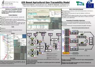
GIS Based Agricultural Geo-Traceability Model w w w. g r a i n l a b. o r g Hafize Gunsu Gemesi1(hggulden@iastate.edu), Charles R. Hurburgh2 (tatry@iastate.edu) 1 Department of Agricultural and Biosystems Engineering, Iowa State University, Ames, IA, 1,2 IOWA STATE UNIVERSITY Definition of Traceability: ISO 8402 GIS for Field Activity Mapping “The ability to trace the history, application location of an entity by means of recorded Identifications” • GIS connects to simultaneous serial real-time data streams in the field (i.e. GPS, SCUFA, 10-AU) • GIS combines incoming data and maps the readings in real-time as subsequent dots. • The subsequent GPS readings (combine, cart) are overlaid on a rectified aerial photograph so that the actual position of each activity in relation to the study area (Farm) can be determined. Project Objectives • Provide information for specific production practices (IP, organic, etc.) • Visualize traceability data in a clear and intuitive way on maps and make use of GIS to study the relationships between environment and the production parcels • Creation of information system that is compliant with legal requirements (FDA Bioterrorism Act, ISO 22000: 2005, etc.) • Visual demonstration of product movement Geographical Traceability in Agriculture • Acquisition and processing of geographic referenced farm level data • Geographical traceability indicators will relate production lots and their environment. • web based infrastructure manage geographical traceability information Tools • ArcGIS 9.2 • ArcSDE Enterprise Database Management Software • 2005 SQL Server database • Figure 2 above shows partial GIS based Farm Traceability Model Results • Figure 4 above shows the real-time data acquisition for a single lot Next Steps • Figure 3 above shows the lot dynamics and transformation of lots at the farm • Creation of web based infrastructure that will help to manage geographical traceability information Creation of Geo-identifier A geo-identifier locates a map object or a production parcel while an agricultural product is processed. • Figure 1 above shows the how farm management data can be related to specific geographic location (LOT) by using GIS based database management tool • Analysis of new ISO 22000 Food Safety and TraceCore Standards and integrated of GIS traceability concept