Download
1 / 41
470 likes | 1.08k Vues
LITHOSTRATIGRAPHY AND THE CRETACEOUS OF THE NORTH SEA. A Brief Outline of Concepts It is not Easy!. Stephen Crittenden Independent Geological Consultant. TALK STRUCTURE. Define Stratigraphy Onshore and Offshore Define lithostratigraphy Cretaceous Subsurface lithostratigraphy schemes

E N D
LITHOSTRATIGRAPHY AND THE CRETACEOUS OF THE NORTH SEA A Brief Outline of Concepts It is not Easy! Stephen Crittenden Independent Geological Consultant
TALK STRUCTURE • Define Stratigraphy • Onshore and Offshore • Define lithostratigraphy • Cretaceous Subsurface lithostratigraphy schemes • Criteria and Method • Forward and Onwards
FIRST, WHAT IS STRATIGRAPHY? • Stratum = Latin • Graphia = Greek • As trained geologists we are all familiar with stratigraphy. • Defined as ”the description of all rock bodies forming the earth’s crust and their organisation into distinctive, useful, mappable units based on their inherent properties or attributes in order to establish their distribution and relationship in space and their succession in time, and to interpret geological history”.
StratigraphyConventional Purist Stratigraphy Concept Stratigraphy comprises: • Lithostratigraphy • Biostratigraphy • Chronostratigraphy • Sequence Stratigraphy • Seismic Sequence Stratigraphy • Magnetostratigraphy • Other stratigraphies based on other properties of rock bodies. For example ’Flow Units’, Chemical Composition, Heavy Minerals
STRATIGRAPHICAL UNITS Table of units
Stratigraphy Models • As working petroleum geologists we deal extensively with sub-surface data rather than outcrop data. • For the North Sea explorer we deal exclusively with offshore material • We must still retain a classical academic approach to stratigraphy – first principles, to underpin our Pragmatic, Working Stratigraphy. • We have to work with a pragmatic philosophy. • Often the ’stratigraphies’ erected by the industrial petroleum geologist are neither strictly defined nor procedurely correct. They are an immediate adequate means to an end but inevitably will cause problems in the future. • Stratigraphy is an important part of the geologists tool-box used by explorationists to find hydrocarbons. Do it Right. • But, not all geologists are stratigraphers!
OFFSHORE STRATIGRAPHY The key to the offshore is the onshore
OFFSHORE STRATIGRAPHY • Stratigraphical schemes for the offshore are constructed / erected with reference to the vast database of onshore information. • This can be illustrated by reference to the lithostratigraphy of the Lower Cretaceous Albian Stage.
Lowermost part of the Rodby Formation & Upper part of Sola Formation equivalent onshore UK
The Red Chalk Formation and Rødby Formation onshore equivalent = the Hunstanton Formation
WHAT IS LITHOSTRATIGRAPHY?The part of stratigraphy that describes and names rocks based on lithology and stratigraphical relationships and the use of that data to organise rock bodies into lithostratigraphical units. • Lithostratigraphy is only part of the overall picture seen by the petroleum geologist. • Lithostratigraphy is an important building block for model generation in the search for oil and gas. • The aim of the petroleum geologist is the generation of an overall, all-encompassing stratigraphy model which aids in the search for oil and gas. Lithostratigraphy is a part of that model.
Cause and Affect Philosophy Common Causes in the environment of deposition affect Faunas & Floras Lithology Which if all other factors are equal , in turn control Fossil Assemblage data Drilling data incl. ROP, Torque, Gas LWD response data And are interpreted to derive Lithostratigraphy Biostratigraphy Which all together produce INTEGRATED ’EVENT STRATIGRAPHY’
Lithostratigraphy:a part of Stratigraphy- a tool in the geologist’s tool-box
THE PRESENT IS THE KEY TO THE PASTAn Ideal Solution An instant later the time travelling stratigrapher, with his thermometer, is obliterated leaving the warm blooded / cold blooded dinosaur debate unresolved
Formal Lithostratigraphy ClassificationAn establishedConventional Unit heierarchy. Units are recognised by observable physical features. Group – comprises two or more contiguous or associated formations. Associated groups may be part of a Supergroup. Formation – the primary unit of lithostratigraphy recognised solely on lithology. It has to be mappable. Member – a named lithological subdivision of a formation that may extend into other formations. Bed – a named distinctive layer in a member or formation. A key bed or a marker bed. Unit Boundaries do not define time lines. Fossil content may be a diagnostic lithological component.
ESTABLISHING LITHOSTRATIGRAPHICAL UNITSProcedure • Type localities / Stratotypes – clear and precise. With auxillary reference sections. • Boundaries – positions of lithological change. In the subsurface define the boundary at the top occurrence of the particular rock type.
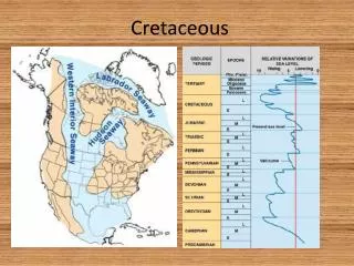
Cretaceous Subsurface Lithostratigraphy Schemes • A Progression from the simple to the complex. • Use both onshore surface and subsurface data with offshore subsurface data. • As a basin is explored the ’schemes’ erected become more and more detailed. • Schemes developed initially are parochial as each Oil Company and each country involved in the basin erect their own ’secretive models’. • Later Co-operation results in better understanding, data sharing and in better models.
Lower Cretaceous Lithostratigraphy Models Compared– North Sea
Upper Cretaceous Lithostratigraphy Models Compared – North Sea
Subsurface lithostratigraphy units and schemes In practise identified and / or defined by the petroleum geologist using both: • Lithology and • LWD / Wireline log shapes
Pragmatic Lithostratigraphy The Petroleum Geologist utilises all data at the wellsite for identification of lithostratigraphic units; formal and informal.
Example Conventional Lithostratigraphy Paleocene section on flanks of structure is more complete and usually includes Vaale and Ekofisk formations. 1. Palaeocene section over the crest of the structure is incomplete from the base upward. 2. Formations pinch out around and onto the flanks and are absent on the crest. This accounts for the lack of the Vaale and Ekofisk formations over the crest of the structure. Hordaland Group 3. This also accounts for the patchy distribution of the Cenodiscus Claystone Member over the structure. Formations Rogaland Group Pinch-out (onlap / offlap) of the structure by the lower part of the Palaeocene section has a major impact on casing pick. The amount of section to be drilled through the Lista Formation is going to be variable. Informal Member status, usually at wellsite can only be reliably identified by palaeo Ekofisk Formation is part of the Shetland Group
LWD Log ’Lithostratigraphy’ – Idealised EventsCrestal location GR response trend is rather flat. Clyst: lt gy – gy, lt blu grn gy, frm, blky – sub fiss, silty, sli calc, tr mica, glc. GR response background trend change; trend slowly increases in value downhole. Stringers of Dol, reddish brn, brn gy, off wh, hd, xln. Clyst more varicoloured – bluish, prplsh with depth. Reworked tuffs. ’False Balder Formation’ peaks = reworked horizon (s). Stringers of Chalky Lst, wh – lt brn, frm – hd, brit, sucrosic. Associated with increase in gas values. Upper Red Claystone Marker. Top Balder Formation 2613mMD, -2367m Gas peak from Balder = higher resistivity. Fork peak. Tuff – tuffaceous clyst: lt – med gy, speckled wh – gy, blky, sft – friable, sli calc, qtz incl. Clst: varicoloured grn, lt grn. Top Sele Formation 2625mMD, -2378m GR values higher than Balder. Clst: dk - lt brn – earthy brn, lt-dk grn interbeds, sft, slty, pyr. Top Lista Formation 2634mMD, -2386m GR ’Bow’: peak, cutback, peak. Clst: varicoloured, lt grn, dk bluish grn, dk grn, gy, lt gy, sft- frm, blky, smooth, waxy appearance, pyr, glc/chl, siderite. Lst intbeds, gy- wh. Clst, red brn, chocolate brn, = Lower Red Marker. GR peak characteristic of some crestal wells. Top Tor Formation 2653mMD, -2403m
Subsurface LithostratigraphyModels • Good cuttings quality for Lithology description. • Accurate lag time. • Caught on depth. • Hole in gauge and well cleaned. • No caving. • Close interval: 3m intervals. • Spot cuttings samples when necessary. • Good Core Data is an ideal. • Good Drilling Data – ROP, WOB, Torque. • GR & Resistivity response from LWD. • Good data quality.
Lithological Description from cuttings Undiff E. Eocene interval Upper Red Claystone Balder Formation Tuffs Sele Formation Lista Formation Lower Red Claystone Chalk
Pragmatic approach for correct identification of the lithological unit. Use all available data. It is best to be prepared!
Cretaceous Lithostratigraphy Monotonous Stratigraphy ? ”after all, it’s all white and Chalk is Chalk isn’t it?” ”anyway the Lower Cretaceous is all claystone”
Points of View – It is useful to step back and gain a broader perspective It’s the Plenus Marl G0 Bed It’s the Herring Formation Actually, it’s the Chalk Group (and it’s a mammoth not a herring!)
Chalk LithostratigraphyVariety of schemes for various regions of the North Sea • Chalk interfingers with the Shetland claystones. The previously illustrated slide (22) shows the complexity and detail of the lithostratigraphy. • Each lithostratigraphical unit has to be illustrated by a type well section. • For Norlex: we have to use the existing defined and published type well sections. • Norlex can illustrate and designate reference wells. • Chalk is not monotonous: there are subtle and mappable differences.
Chalk – Lagerdorf Saturn Quarry, GermanyThe white stuff we drill through.Some layers and fractures / faults visible.
Faulted white stuff – Lagerdorf Saturn QuarrySlightly more interesting – well defined lithological layers and clear faulting.
Reservoir Stratigraphy • Geological Model for a Chalk reservoir is complex; it is not a simple layered cream-cake. • Faults and Fractures, both small scale and large scale are present but not all are possible to model from seismic.
Field Reservoir StratigraphyPerhaps there is more to Chalk than meets the eye! Detailed Stratigraphy – flow units, ’lithostratigraphy’ and biostratigraphy
Lithostratigraphical studies of the CretaceousIs it a success story? • Effective people • Effective data and QC of data • Effective acquistion and interpretation of data • Effective modelling • Effective software • Effective communication • Effective documentation Objective: A holistic understanding of all the subsurface data and how it all slots together to achieve a lithostratigraphic model.
Forward VisionClear vision, rationale and plan for the process of building an effective Lithostratigraphic Model. • Review Model sessions. • Feedback, consolidate and discuss. • Re-define vision, strategy (ies) and methods. • Identify any changes necessary • Identify any impediment to change • Identify any other resources needed: skills, tools, people. • Time frame required for change