Download
1 / 15
150 likes | 172 Vues
Discover the significance of soils data and its pivotal role in various essential resources such as geodetic control, elevation, and transportation. Explore tangible and virtual resources offered by USDA-NRCS for accessing crucial soil information efficiently.

E N D
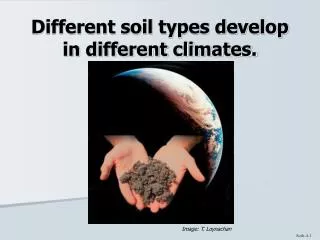
SOILS: The Forgotten Framework Layer Bruce Nielsen GIS Specialist USDA-Natural Resources Conservation Service
Why Was Soils Data Forgotten? • Geodetic Control • Orthoimagery • Elevation • Transportation • Hydrography • Government Units • Cadastral How many of these would exist without Soils?
Tangible Resources Printed Soil Survey Soil Survey on CD For people without access to GIS software Virtual Resources On-Line Soil Surveys All the information, none of the mass Soil Data Mart Tabular Reports Data Downloads Geospatial Data Gateway Data Downloads More than just soils What Info Does NRCS Offer?
On-Line Soil Surveyshttp://www.in.nrcs.usda.gov/mlra11/manuscript_publications/Manuscripts.html • Manuscript • Map Sheets • All in Adobe PDF format
Soil Data Marthttp://soildatamart.nrcs.usda.gov • Generate Reports • Download Data • Tabular and/or Spatial • Subscribe • Be informed by emailif changes occur • National Status Maps
Soil Data MartDownload Data • Spatial • Tabular • Both
Soil Data MartSpatial Data • Soil Map Units • Special Features • Too small to be represented by a polygon • Line or Point • Table containing definitions is included
Soil Data MartTabular Data • Properties • Attributes • Interpretations
Soil Data MartSubscribe • Receive Notification if a county’s Survey is Updated • Download Multiple Datasets Without Re-Entering Email Address bruce.nielsen@in.usda.gov *******************
Geospatial Data Gatewayhttp://datagateway.nrcs.usda.gov • Select Area • Select Data • Select Projection & Format • Select Delivery Method • Wait for the Email
Current Availability (Indiana) • Recently Certified: • Clay